raeann
Well-Known Member
- Joined
- Jul 7, 2008
- Messages
- 5,250
- Reaction score
- 441
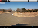
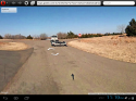
Well I never am too successful at doing maps but will try this one. At the very southern tip of the lake, if you zoom in, you can see how there is a road that goes along the edge of a parking area and straight onto the boat ramp. Anyone driving at night, who was unfamiliar with the exact situation, may have driven straight off the ramp and into the water. They could have done so at a significant rate of speed if they believed they were on an actual road.
https://maps.google.com/maps?q=foss+lake+oklahoma&ie=UTF-8&ei=Rds5UvzdF4W52wXWnYCoAQ&ved=0CAoQ_AUoAg
https://maps.google.com/maps?q=foss+lake+oklahoma&ie=UTF-8&ei=Rds5UvzdF4W52wXWnYCoAQ&ved=0CAoQ_AUoAg