TravelingBug,
I had a question for you since you are familiar with the area, if you don't mind answering.")
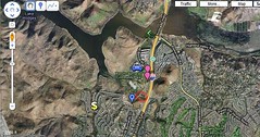
After seeing the pictures you posted of the park and surrounding areas, it seems almost crazy to me to think the security guard at Casa actually saw Chelsea park and get out of her car to start running. I could be wrong (and that's why I am asking you) but in the picture you showed where it shows the Rec Center, where her car was parked, and Casa at the very top of the picture, it seems like a pretty far distance for him to have been able to notice her, let alone be certain it was Chelsea. Am I way off on this? I know pictures can be deceiving sometimes, especially when it comes to distance.
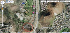
Also, I'm not sure how accessible those houses are from the trails but is it possible that someone who was also "jogging" on the trail started making small talk with Chelsea and lured her to a nearby house for some reason? Just a thought.
I had a question for you since you are familiar with the area, if you don't mind answering.
After seeing the pictures you posted of the park and surrounding areas, it seems almost crazy to me to think the security guard at Casa actually saw Chelsea park and get out of her car to start running. I could be wrong (and that's why I am asking you) but in the picture you showed where it shows the Rec Center, where her car was parked, and Casa at the very top of the picture, it seems like a pretty far distance for him to have been able to notice her, let alone be certain it was Chelsea. Am I way off on this? I know pictures can be deceiving sometimes, especially when it comes to distance.
Also, I'm not sure how accessible those houses are from the trails but is it possible that someone who was also "jogging" on the trail started making small talk with Chelsea and lured her to a nearby house for some reason? Just a thought.