Malaysia airlines plane may have crashed 239 people on board #22

Status
Not open for further replies.
A couple days old, but nonetheless:

"Investigators reveal MH370 co-pilot tried to make a call from his mobile phone after the aircraft 'vanished' but 'was abruptly cut off'"

article-2603075-1D0DC20D00000578-204_634x507.jpg


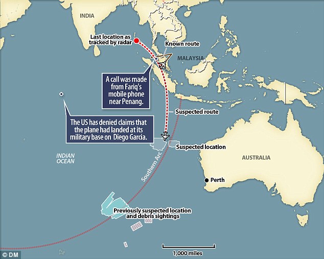
It appears that is when MH370 was flying erractically, perhaps it was his last ditch to make communication to someone, anyone?

Read more: http://www.dailymail.co.uk/news/art...ormal-communication-ground.html#ixzz2yuVjyNpU
Last weeks map (below), the plane 'flew around Indonesian airspace after it dropped off Malaysian military radar.' Link
However, Elle Elle's map (above) from a couple of days ago, shows the plane flying directly over Indonesia... did the flight path change? In other words, instead of the plane skirting around Indonesia, it flew over Indonesia?

plane040614.jpg

Not sure of anything at this point, but I think they are totally basing the flight path 'around Indonesia' on Indonesia's claim that it didn't show up on their radar?
 
A Japanese pilot was asked to try and make contact with MH370 and did but was unable to understand because of the static. So how could Malaysia say there were unaware of the fact that the flight was missing? The Vietnamese were very much aware that MH370 never made contact with them because other pilots in the area were made aware of it 10 minutes after Flight MH370 signed off with Malaysia.


http://www.theblaze.com/stories/201...-made-contact-with-missing-malaysian-flight/#


Very Interesting indeed.
 
Wonder if any of the passengers or crew were involved with this discovery?

Perhaps some of the info gleaned from that research may help in this case.

Could there be any possibility at all, that the plane is under ice?


http://www.thestar.com/news/world/2...nder_antarctic_ice_for_millions_of_years.html
By: Vladimir Isachenkov Associated Press, Published on Wed Feb 08 2012


"In the future, Russian researchers plan to explore the lake using an underwater robot equipped with video cameras that would collect water samples and sediments from the bottom of the lake, a project still awaiting the approval of the Antarctic Treaty organization.

The prospect of lakes hidden under Antarctic ice was first put forward by Russian scientist and anarchist revolutionary, Prince Pyotr Kropotkin at the end of the 19th century. Russian geographer Andrei Kapitsa pointed at the likely location of the lake and named it following Soviet Antarctic missions in the 1950s and 1960s, but it wasn't until 1994 that its existence was proven by Russian and British scientists.

The drilling in the area began in 1989 and dragged on slowly due to fundingfunding shortages, equipment breakdowns, environmental concerns and severe cold".
 
Instead of programming it to stay 30 meters above, they should just make it 130 meters or 200 meters above and they have much less chance of hitting the maximum depth.

A guy on CNN said they do like to get it as close to bottom as possible because the sonar pictures are much more detailed that way. But IMO just to locate that plane they could keep the thing about 200 meters above and still spot the plane. Sometimes I think the operators lose sight of the big picture here. FIND THE DARN PLANE FIRST PEOPLE. Then worry about getting good detailed pictures so you can plan a retrival of the box.

You dont need good detailed pictures to spot the outline of the plane.

More detailed mapping makes it much easier to distinguish between targets on the ocean floor. Considering that they’re not dealing with a photographic image like you would get from your camera, the difference between 30 metres and 130 metres may mean mistaking a piece of the wreckage for a boulder, or vice versa - and that could lead to even longer delays in the long run.

Better (and far more compassionate) to do the job well the first time, IMO.
 
But we do not know at what level the plane was flying before going into the ocean, do we?
The radar is supposed to be capable of monitoring shipping traffic out there, so the altitude of the plane shouldn't matter much.
 
Wonder if any of the passengers or crew were involved with this discovery?

Perhaps some of the info gleaned from that research may help in this case.

Could there be any possibility at all, that the plane is under ice?


http://www.thestar.com/news/world/2...nder_antarctic_ice_for_millions_of_years.html
By: Vladimir Isachenkov Associated Press, Published on Wed Feb 08 2012


"In the future, Russian researchers plan to explore the lake using an underwater robot equipped with video cameras that would collect water samples and sediments from the bottom of the lake, a project still awaiting the approval of the Antarctic Treaty organization.

The prospect of lakes hidden under Antarctic ice was first put forward by Russian scientist and anarchist revolutionary, Prince Pyotr Kropotkin at the end of the 19th century. Russian geographer Andrei Kapitsa pointed at the likely location of the lake and named it following Soviet Antarctic missions in the 1950s and 1960s, but it wasn't until 1994 that its existence was proven by Russian and British scientists.

The drilling in the area began in 1989 and dragged on slowly due to fundingfunding shortages, equipment breakdowns, environmental concerns and severe cold".

This just confuses me a wee bit... If plane was to be under ice, would that not put it way out of the search area? Or is it on the assumption that the ocean floor is so cold, there's ice there?

Forgive me for possibly seeming daft but i'm just wondering?
 
This whole thing just blows my mind and here we are - however many days later - and no clue. It's really very scary. I feel so bad for these people.
 
(CNN) -- The underwater probe being used to look for missing Malaysia Airlines Flight 370 was back in the water after its first attempt ended prematurely, said the company that owns the vehicle, Phoenix International.
The Bluefin-21 autonomous underwater vehicle was about four hours into its second dive mission at 2 p.m. ET on Tuesday (2 a.m. Wednesday in Perth, Australia), a source close to the operation told CNN's Brian Todd.
On Monday, crews sent the probe toward the ocean floor on what was expected to be a 20-hour deployment, only to have it return in less than eight hours after encountering waters beyond its 4,500-meter (14,764-foot) maximum depth.
The probe found no debris during its shortened scanning session.


http://www.cnn.com/2014/04/15/world/asia/malaysia-airlines-plane/index.html?hpt=hp_t2
 
A Japanese pilot was asked to try and make contact with MH370 and did but was unable to understand because of the static. So how could Malaysia say there were unaware of the fact that the flight was missing? The Vietnamese were very much aware that MH370 never made contact with them because other pilots in the area were made aware of it 10 minutes after Flight MH370 signed off with Malaysia.


http://www.theblaze.com/stories/201...-made-contact-with-missing-malaysian-flight/#

The answer is in your post LambChop

Malaysia ATC had handed off MH370 to Vietnam ATC so they were no longer tracking MH370
I am questioning WHY Vietnam did not alert their military since they were the ones who knew First that MH370 was missing.

1:21AM Vietnam ATC realized MH370 did not check in, tried to contact them but got nothing..they are not showing up on radar

1:30AM Vietnam ATC then asks a pilot flying another 777 in the area to try and contact MH370

1:40AM Vietnam ATC informs Malaysia ATC that they flight is missing
 
Last weeks map (below), the plane 'flew around Indonesian airspace after it dropped off Malaysian military radar.' Link
However, Elle Elle's map (above) from a couple of days ago, shows the plane flying directly over Indonesia... did the flight path change? In other words, instead of the plane skirting around Indonesia, it flew over Indonesia?

plane040614.jpg

ELLE Elle's maps shows the guide map of the Southern arc route investigators put together from the Satellite pings from Inmarsat..

At first they did not know which route the plane took..the northern arc or southern arc

Your map of the plane going around Indonesia is based on Military Radar, iirc.
 
My daughter works in aviation and is extremely knowledgeable about this whole subject, esp. the model of aircraft in question. However, she is not following the story very closely. When I asked her why she said, "So far the 'story' is nothing but questions. Once the story has even one 'answer' then I'll follow it."
 
ELLE Elle's maps shows the guide map of the Southern arc route investigators put together from the Satellite pings from Inmarsat..

At first they did not know which route the plane took..the northern arc or southern arc

Your map of the plane going around Indonesia is based on Military Radar, iirc.


Whose radar? Do you possibly have a link?
 
Whose radar? Do you possibly have a link?

I don't think WHO's or Which countries radar(s) have ever been released publicly..most likely classified information.

But we do know Malaysia did ask foreign countries ( neighbouring countries and other foreign countries) for help and asked them to re-examine their military radar and satellite data ..that as far as we, the public know.


http://www.bbc.com/news/world-asia-26603830 MARCH 16, 2014
Malaysia has now asked other countries around the region and beyond to review their radar playbacks, both primary (mainly military) and secondary (chiefly civilian).

http://www.nytimes.com/2014/03/17/world/asia/malaysia-airlines-flight.html?_r=0 MARCH 16, 2014

Malaysian officials on Sunday briefed representatives from 22 countries that could help search along the two corridors where satellite data indicate the plane may have wound up, having flown up to six hours after its disappearance beyond the range of military radar in western Malaysia. Mr. Hishammuddin said Malaysia would also ask China, France, the United States and other countries to provide satellite data.

http://www.ctvnews.ca/world/thailan...ave-tracked-missing-malaysian-plane-1.1734438 MARCH 18, 2014

Ten days after a Malaysian jetliner disappeared, Thailand's military said Tuesday it saw radar blips that might have been from the missing plane but didn't report it "because we did not pay attention to it."

Thailand's failure to quickly share possible information about the plane may not substantially change what Malaysian officials now know, but it raises questions about the degree to which some countries are sharing their defence data. At a minimum, safety experts said, the radar data could have saved time and effort that was initially spent searching the South China Sea, many miles from the Indian Ocean.
 
I just got back after a month away! I have been watching the continuous "Breaking News" on CNN. Reminds me of NGrace's "Bombshell Tonight". I'm sure this has been discussed but to get me up to speed...what is everyone's take on the co-pilot's phone pinging off a Malaysian cell tower?

BBM.
I don't think it really means a whole lot.
To me, all it means is that his phone made contact with a cell tower when the plane was at a lower altitude. It doesn't necessarily mean a call was made (like the media seems to think), just that a signal was sent to the tower. His phone could have either been off and then switched back on, or it was on the whole time, and a ping was made at the lower altitude. Or it was switched from airplane mode to regular mode.
 
Status
Not open for further replies.

Staff online

Members online

Online statistics

Members online
213
Guests online
1,922
Total visitors
2,135

Forum statistics

Threads
592,219
Messages
17,965,331
Members
228,723
Latest member
brentr
Back
Top