Geographic Profiling

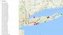
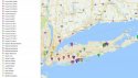
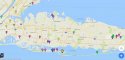
Thanks dotr. Is there a marked map with the original location or last known location of the victim (if known) and where they were located? I've been looking at geographic maps of long island and learning about the area. I notice that Atlantic City is south of there. I think the murderer lives south of Long Island, probably in New Jersey. I don't know much about this area at all, please forgive me!

I've been thinking about New Jersey a lot. I haven't seen it posted anywhere yet about Asbury Park, but earlier Hatfield made a post about Anthony Bourdain and his love for NJ bLA bla it got me thinking about Asbury Park, one of the craziest places I've been in my life btw, when it was abandoned, and Reagan let those mental patients out, they still lived there lol, we stayed at a haunted hotel there, it was lIke a ghost town, i think we finally found a burger at a stripjoint, the only business open a few mIles away...We were at Bruce Springsteen joint, a live music club. Yeah The Stone Pony. I think MJ owned AP for a while, supposedly it was swiiiingin back in the day...I heard it's been built back up?

Has this ever been mentioned, pondered, AP? Earlier I found a couple different msms, skulls...not sure where I posted it.
 
wonder why no one has ever really mentioned that skull mural that used to be in gilgo(i think it's gone now)--i think the number of skulls in it matches
 
Here is a theory, look at when the first victim was found off the island , then the time frame when they found the first victim on the island , they mentioned queens.
I say its a cop or law enforcement that transfered to another job to queens, perhaps a correctional officer, Correctional officers have the means of information from inmates.

Berlap bags, only one place sold them , look who had 4 trees planted around the killing times, probably a friend of the officer that killed himself.
Just a thought.

:welcome:​

'Just'an overwhelming 'thought', Michael1973. Makes so much sense to me. Thank you for sharing it, for joining and just keep thoughts such as these coming, please.
 
Josh and Rachel~~great show~~~great work. Kuddos to you both. Hopefully both of you will be up for a reward, just like MaM.
:goldcrown:

Please forgive me as I'm not familiar with the type of work most of these ladies were in...

A few questions/random thoughts...

Is is common to use a name other than your own in this type of business? The reason I ask, is 3 of the identified victims seem to begin with the letter "M" and I'm wondering if Amber could have possibly have gone by a name that begins with "M". Also, along those lines, if that appears to be the case, I'm wondering if someone in LISK's family (maybe mother???) name would also begin with an "M".

I also noticed a recurring theme of the number 5. As in the 500 feet distance (which I realize has been disproven.) But, it seems there were 5 in a row. 4 insiders and 1 outside (the Asian male). I'm wondering if that signifies something more. Perhaps, LISK was born out of wedlock when mother was in the same type of work and mother remarried into a family with 3 other children (females) and LISK always felt like the outsider?

Can we trace the number of victims to perhaps a phone number or address? IIRC, the victims were found in multiples of 2, 4, 2, 2 or 2, 5, 1, 2. On the A&E map~~it appears the first 2 victims were spaced apart, as if he planned to fill it in with other victims~~then 4 together, then 2 apart, and then 2 together.

IIRC, hurricane Sandy hit LI~~was there any attempt by LE to go back to the site to see if any other evidence was uncovered?

Lastly, I'm a numbers person...LOL~~so I was looking at the spacing posted by Shadowraiths. Hi Shadowraiths :seeya:!!!

Costello & Barthelemy: 0.16 mi = 257.495 m
Barthelemy & Barnes: 0.05 mi = 80.4672 m
Barnes & Waterman: 0.07 mi = 112.654 m
Waterman & John Doe: 0.28 mi = 450.616 m
John Doe & JT: 0.62 mi = 997.793 m
JT & Jane Doe 6: 1.43 mi = 2301.361 m
Jane Doe 6 & Baby Doe: 0.04 mi = 64.3737 m

So, here goes...(just approximating)

The distance between Barthelemy & Barnes was 80 meters. The distance between Jane Doe 6 and Baby Doe is 64. 80-64 = 16 meters.

The distance between Barthelemy & Barnes was 80. The distance between Barnes and Waterman is 112. 112-80 = 32.

16 x 2 = 32 coincidence? Perhaps?

32 x 2 = 64
64+12 = 80

There seems to be a pattern revolving around the number 16.

64/16=4
80/16=5
112/16=7
257/16=16.0625
450/16=28.16
except these two don't have a multiple of 16, unless there is some other multiple.....
997/16 = 62.3125
2301.361 /16 = 143.83

The first 3 are disconcerting..was there anything found at 96? Like possibly another victim? Victim #6, perhaps?? Are there 2 others at 16 and 32 meters??

So good to see you posting here and sharing your thoughts, BCA:loveyou:
You have a brilliant mind!
 
I posted this in GB4 section, because it still pertains to it...and to AC4 site. I realize that I'm not profiling geographically according to the strict definition of the term & how it's done, but here goes nothin!

I was a little nervous suggesting what I still believe about LISK leaving clues to direction of his business, home, or killing site.
Then last night, the FBI Profiler from Florida commented on the AC4 & suggested their faces being pointed East might suggest "the direction to his home".

This is what I've believed, but I've only been involved with this for about a week.

I was mistaken however; I told Rachel & Josh that I disagreed with the Florida SK. He said the killer is a Mission Killer because of his "cravings from his foot fetish". The problem with that assessment (all due respect to him) is that ALL SK's CRAVE to kill. Mission Killers kill for a specific purpose, such as to do God's work by ridding the world of "depraved prostitutes" (definition by SK's...not my def'n of prostitutes).
Therefore, I think the FBI profiler is very possibly correct. This might be a Mission Killer, but they're the same one. See below some items not mentioned that I discovered.

1) When I checked the longitudinal & latitudinal coordinates of the GB4 site & the drainage ditch behind the Golden Key Motel in (8030 Black Horse Pike; Pleasantville, NJ) just outside of Atlantic City, I was startled to find that these 2 locations have almost the exact Latitude! Only the longitudes are N and S of each other.

2) Since GB4 were north of AC4 killings, and using my theory of the numbers (both 4 victims, btw) of 500 divided by 4 which = 125 (125 degrees ESE), I began to look across the Atlantic to find islands that either suggest connections with these coordinates or an INTERSECTION OF 125 Degrees ESE & STRAIGHT EAST FROM AC4 Site (Golden Key Motel).

3) After being frustrated for hours, I finally discovered 2 islands that show promise.
a) Island in Portugal is directly EAST of Golden Key Motel. Exactly the same Latitude of +39.9
or +40 Latitude. The problem is that this island doesn't satisfy the assumption that both burial sites
gave their own directions.

4) There's another much closer island to the U.S. And its coordinates are +32.36 N -64.7671 W. These are the coordinates of the LF Wade International Airport at 3 Cahow Way on Bermuda Island.
My curiosity with Bermuda is that both sites, each with 4 bodies, each with indications of possible directions to the SK's home, business, or killing site, might be pointing to Bermuda in some fashion.

I can't figure out yet how to draw a line 125 degrees ESE from Gilgo Beach to see if it crosses Bermuda yet, but I'm studying, and I'll let you know.

Waiver: I don't think that Bermuda is the key (yet). I'm just gathering information.
Thanks!
 
This site is interesting:

http://tinyurl.com/jybfdxx

Not sure if it's of any value, but it basically shows the midpoints of all points you enter. For all the points related to LISK (see map posted by BillWarnerPI on previous page of thread), it found that the midpoint was close to a Planet Fitness in Melville, NY.

Cool, thanks.

"Geographic Midpoint Calculator

Finds the exact point that lies halfway between two or more places. Find your personal center of gravity--the geographical average location for all of the places you have lived in. See the results on a Google Map."
 
I have been a long time fan of geographical profiling... which began with Dr. Rossmo's Jeopardy Surface, in conjunction with my forensic psych master's studies over a decade ago.

I did play around some with the LISK cases, which resulted in this basic map, and the basis of my free iOS SK Tracker app.

Notably, the latter has many more points than the Google Maps version, as my eventual goal was to include a means for dynamic geographic profiling. So, for example, profiling the GB4, Manorville, Cold Spring Harbor, Southern State Parkway, together, individually, or any combination thereof.

In any event, I did some manual calculations, based upon the Gilgo Beach & Manorville abduction/dump sites, with the assumption of a single killer, and the "hot spot" was Massapequa.

Way cool, thanks shadowraiths.

Here are some initial screenshots from your map to view inside the thread.

attachment.php


attachment.php


attachment.php


attachment.php


attachment.php
 

Attachments

  • Screenshot_2016-11-20-09-10-23.jpg
    Screenshot_2016-11-20-09-10-23.jpg
    79.1 KB · Views: 99
  • Screenshot_2016-11-20-09-11-01.jpg
    Screenshot_2016-11-20-09-11-01.jpg
    81.5 KB · Views: 100
  • Screenshot_2016-11-20-09-11-36.jpg
    Screenshot_2016-11-20-09-11-36.jpg
    63.3 KB · Views: 99
  • Screenshot_2016-11-20-09-12-16.jpg
    Screenshot_2016-11-20-09-12-16.jpg
    26.7 KB · Views: 98
  • Screenshot_2016-11-20-09-12-44.jpg
    Screenshot_2016-11-20-09-12-44.jpg
    26 KB · Views: 96
(Continued from above )

I have been a long time fan of geographical profiling... which began with Dr. Rossmo's Jeopardy Surface, in conjunction with my forensic psych master's studies over a decade ago.


I did play around some with the LISK cases, which resulted in this basic map, and the basis of my free iOS SK Tracker app.


Notably, the latter has many more points than the Google Maps version, as my eventual goal was to include a means for dynamic geographic profiling. So, for example, profiling the GB4, Manorville, Cold Spring Harbor, Southern State Parkway, together, individually, or any combination thereof.


In any event, I did some manual calculations, based upon the Gilgo Beach & Manorville abduction/dump sites, with the assumption of a single killer, and the "hot spot" was Massapequa.


attachment.php
 

Attachments

  • Screenshot_2016-11-20-09-13-34.jpg
    Screenshot_2016-11-20-09-13-34.jpg
    39.1 KB · Views: 96
Respectfully snipped for brevity.

Yes, I'm a numbers person, too! Hi BCA :seeya:!!!

Though, I looked at it from a different perspective... that is from a geographical profiling angle, using Rossmo's Jeopardy Surface formula. If you look at it from this angle, you'll see that there are built-in limitations that are a result of Rossmo's assumptions (i.e., transportation, comfort zone, etcetera).

From the Geographic Profiling link above:

"Geographic profiling is a criminal investigative methodology that analyzes the locations of a connected series of crimes to determine the most probable area of offender residence. By incorporating both qualitative and quantitative methods, it assists in understanding spatial behaviour of an offender and focusing the investigation to a smaller area of the community. Typically used in cases of serial murder or rape (but also arson, bombing, robbery, terrorism[1] and other crimes), the technique helps police detectives prioritize information in large-scale major crime investigations that often involve hundreds or thousands of suspects and tips.


In addition to determining the offender's most likely area of residence, an understanding of the spatial pattern of a crime series and the characteristics of the crime sites can tell investigators other useful information, such as whether the crime was opportunistic and the degree of offender familiarity with the crime location. This is based on the connection between an offender's behavior and his or her non-criminal life.[2]


Geographic profiling is growing in popularity and, combined with offender profiling, can be a helpful tool in the investigation of serial crime."
 
Margarita25,
Can you describe how to indicate on a map the exact line of a specific direction from Gilgo Beach 4 Site? I'm trying to intersect "Straight East" from AC4 site with 125 degress ESE from the GB4 victims' site.
I know how to find the coordinates, and also found intersections on Portugal Island & Bermuda (much closer), but I can't determine if a vector of 125 degrees ESE intersects with east of AC4 at any significant site. I can't find anything in the Atlantic yet that fits, but I just wondered if you could explain how to do this? Please?

Thx Margarita25
 
I have been a long time fan of geographical profiling... which began with Dr. Rossmo's Jeopardy Surface, in conjunction with my forensic psych master's studies over a decade ago.

I did play around some with the LISK cases, which resulted in this basic map, and the basis of my free iOS SK Tracker app.

Notably, the latter has many more points than the Google Maps version, as my eventual goal was to include a means for dynamic geographic profiling. So, for example, profiling the GB4, Manorville, Cold Spring Harbor, Southern State Parkway, together, individually, or any combination thereof.

In any event, I did some manual calculations, based upon the Gilgo Beach & Manorville abduction/dump sites, with the assumption of a single killer, and the "hot spot" was Massapequa.

Wow, shadowraiths, thanks for all this great stuff.

From the link above re: the free iOS SK Tracker App:

"Description


This application provides interactive crime scene maps for select solved and unsolved North American serial killer cases. In addition to the primary crime maps, victim specific maps may be available when multiple locations are known to exist. These locations can include everything from multiple potential crime scenes (i.e., domicile, place of employment, last seen, where the crime did or may have occurred, where the body was found, etcetera) to known relationships that may be applicable to solving the case. Web content links, where available, are also provided. A psychological profiling information page is included for aspiring profilers."
 
Margarita25,
Can you describe how to indicate on a map the exact line of a specific direction from Gilgo Beach 4 Site? I'm trying to intersect "Straight East" from AC4 site with 125 degress ESE from the GB4 victims' site.
I know how to find the coordinates, and also found intersections on Portugal Island & Bermuda (much closer), but I can't determine if a vector of 125 degrees ESE intersects with east of AC4 at any significant site. I can't find anything in the Atlantic yet that fits, but I just wondered if you could explain how to do this? Please?

Thx Margarita25

I am referring this question to two of our great mappers here, Forager and Skibaboo. Sending them a note, hopefully they can take a look. :wave:
 
if LI is its only case(not tied to A/C or FL),then i would imagine there is another "trophy collection", because GB4 killer likely snapped when his "garden" was discovered/disturbed

Jumping off this post, in cases of other serial killer who had multiple "gardens" (ugh), what were some of these distances between the dumping grounds I wonder.
 
Qmfr:
Anyone think this guy is married? I kind of do...I saw this show on ID, what's is called...oh "Evil Lives Here", I think. I've seen a few episodes where these guys are married and the wives are on the show, talking about their abuse, their mysterious absences late at night etc.

*this post has no scientific reference

*so what percentage of sks are married?

(Sorry about this, I obviously posted this question in the wrong thread last night when I had a million windows open.)
 
Regarding the geographic profiling mentioned earlier, this looks very interesting:

https://tigerweb.towson.edu/moleary/profiler.html

The tool will not run properly on my system; I'm not sure if it is an incompatibility with Windows 10 or if I just don't have enough ram, etc (screen flashes several times before freezing, forces a hard reboot). If anyone could get this to run, this could be cool.

Thanks for posting. This thread is becoming a great wealth of resources.

From the link above:

"The geographic profiling problem is the problem of constructing an estimate for the location of the anchor point of a serial offender from the locations of the offender's crime sites.

We have developed a new mathematical algorithm for the geographic profiling problem based on Bayesian methods that allows us to allow for geographic features that affect crime site selection and for geographic features that affect the choice of an offender's anchor point."
 

Members online

Online statistics

Members online
194
Guests online
1,389
Total visitors
1,583

Forum statistics

Threads
591,773
Messages
17,958,632
Members
228,604
Latest member
leannamj
Back
Top