Deceased/Not Found PA - Anna Maciejewska, 43, Chester County, 10 April 2017

Status
Not open for further replies.
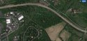
Back in May, the PSP were specifically interested in the area behind the AT+T building off of Valley Road (as per the community meeting that was held). That was where a group search was being organized and was soon after cancelled. This is quite close to her home and not too far from where the car was dropped. I keep wondering about whether there was a LE search there or what ever happened to the interest of the PSP regarding that area.


Sent from my iPhone using Tapatalk
 
The big white building on West Valley Hill road or the old house with the big tower on East Valley Hill near Bodine? I have thought about both of them..
 
The big white building on West Valley Hill road or the old house with the big tower on East Valley Hill near Bodine? I have thought about both of them..

I'm not 100% because it was planned and then cancelled right away. The way it was described was back behind the AT+T building. I don't drive down there often, also I can't picture exactly what they meant.


Sent from my iPhone using Tapatalk
 
The area I have been intrigued by in looking at the satellite maps is the narrow wooded area between Davis RD and the Turnpike. Pine Creek flows through part of that narrow wooded area and there should be a tunnel under the Turnpike because Pine Creek flows on Southwestward toward the business/industrial park. Depending on the size of the tunnel under the Turnpike that may be a place to look. The roads along the business area near the creek afford easy access as well and there may be tunnels there too - I am not familiar with the area and can only go by the satellite view. Large image included (sorry).

attachment.php
 

Attachments

  • PineCreek.jpg
    PineCreek.jpg
    88.9 KB · Views: 278
I'm not 100% because it was planned and then cancelled right away. The way it was described was back behind the AT+T building. I don't drive down there often, also I can't picture exactly what they meant.


Sent from my iPhone using Tapatalk

I think they must mean the one on West Valley Hill. That is the same area as the wooded County land that I mentioned.
 
I see what you all mean. The heavily wooded area between W Valley Hill Rd and Old Valley Road. The AT&T Building is the one with the big microwave tower. 1028 W Valley Hill Rd. I also see two clear cut right of ways. One to the East appears to be for power lines. The one to the west looks like it's for a pipeline. Now how far do you think someone is going to carry a 100+ lb body over their shoulder with a tight time schedule? Only other scenario is the actor made Anna walk into the woods at knife or gunpoint and then killed her.
 
I see what you all mean. The heavily wooded area between W Valley Hill Rd and Old Valley Road. The AT&T Building is the one with the big microwave tower. 1028 W Valley Hill Rd. I also see two clear cut right of ways. One to the East appears to be for power lines. The one to the west looks like it's for a pipeline. Now how far do you think someone is going to carry a 100+ lb body over their shoulder with a tight time schedule? Only other scenario is the actor made Anna walk into the woods at knife or gunpoint and then killed her.

Or she was dumped at the lower end of the hill, along Old Valley Road, which is narrow and little travelled and then her car left at Charlestown Woods.
 
Or she was dumped at the lower end of the hill, along Old Valley Road, which is narrow and little travelled and then her car left at Charlestown Woods.

This is all minutes from her home.


Sent from my iPhone using Tapatalk
 
I see what you all mean. The heavily wooded area between W Valley Hill Rd and Old Valley Road. The AT&T Building is the one with the big microwave tower. 1028 W Valley Hill Rd. I also see two clear cut right of ways. One to the East appears to be for power lines. The one to the west looks like it's for a pipeline. Now how far do you think someone is going to carry a 100+ lb body over their shoulder with a tight time schedule? Only other scenario is the actor made Anna walk into the woods at knife or gunpoint and then killed her.

or..(wince) the person disposed of her in bags. ��
 
Where are you Anna????

I'm still praying you are found!!!


Sent from my iPhone using Tapatalk
 
So I made an attempt to search the Old Valley Road area. Coming in from the Ship Road end, you only are able to navigate the road for a short distance before you come to a barricade. From that point on it becomes part of the Chester Valley Trail until it reaches a large estate located at the intersection of Church Farm Road and Old Valley Road. Church Farm Road is now a private road, probably to keep the curious from driving up to look at the estate...and I do mean estate, as in more money than I would make in a number of lifetimes. Coming in from North Bacton Hill Road, you can go as far as Malvern Hunt road (housing development) before it turns into something like a fire break trail. There were no signs saying not to go further, but seeing that Church Farm road is now private, I cannot see how this rutted dirt road would not be. The embankment on the north side from Bacton Hill to Malvern Hunt is plasterd with No Trespassing Signs, so unless LE is involved, I cannot set foot upon it. I need to do some research to see if I can walk the section from Malvern Hunt to Church Farm without getting shot at.
 
So I made an attempt to search the Old Valley Road area. Coming in from the Ship Road end, you only are able to navigate the road for a short distance before you come to a barricade. From that point on it becomes part of the Chester Valley Trail until it reaches a large estate located at the intersection of Church Farm Road and Old Valley Road. Church Farm Road is now a private road, probably to keep the curious from driving up to look at the estate...and I do mean estate, as in more money than I would make in a number of lifetimes. Coming in from North Bacton Hill Road, you can go as far as Malvern Hunt road (housing development) before it turns into something like a fire break trail. There were no signs saying not to go further, but seeing that Church Farm road is now private, I cannot see how this rutted dirt road would not be. The embankment on the north side from Bacton Hill to Malvern Hunt is plasterd with No Trespassing Signs, so unless LE is involved, I cannot set foot upon it. I need to do some research to see if I can walk the section from Malvern Hunt to Church Farm without getting shot at.


Thanks for looking. Both sides of the road, except for the "estate" and a house still owned by Church Farm School, are owned by the County or the Townships. I don't think the road is "private", but it also obviously isn't maintained for regular traffic by the general public. IMHO, you would not be at risk of getting shot. The ChescoViews map does not indicate that it is owned by the folks that own the estate.
 
Thanks for looking. Both sides of the road, except for the "estate" and a house still owned by Church Farm School, are owned by the County or the Townships. I don't think the road is "private", but it also obviously isn't maintained for regular traffic by the general public. IMHO, you would not be at risk of getting shot. The ChescoViews map does not indicate that it is owned by the folks that own the estate.

Here are a couple of pictures:

20170705_145021_resized.jpg
This is Church Farm Road at Swedesford Road. Note the private road sign.

20170705_144007_resized.jpg
This is Old Valley Road at Malvern Hunt Way where it turns from regular blacktop to paved cowpath. There are no signs, but it goes to the same place that Church Farm road does.
 
Here are a couple of pictures:

attachment.php

This is Church Farm Road at Swedesford Road. Note the private road sign.

attachment.php

This is Old Valley Road at Malvern Hunt Way where it turns from regular blacktop to paved cowpath. There are no signs, but it goes to the same place that Church Farm road does.
That is fantastic that you were able to get out there. Are you close to the area? Is there any chance of taking a look at the area I was looking at from the maps (posted earlier) between Davis RD and the Turnpike and where Pine Creek flows through a tunnel under the Turnpike?
 
That is fantastic that you were able to get out there. Are you close to the area? Is there any chance of taking a look at the area I was looking at from the maps (posted earlier) between Davis RD and the Turnpike and where Pine Creek flows through a tunnel under the Turnpike?

Yes I am close to the area. About 6-8 miles. I will have to check access to the spot where Pine Creek flows under the turnpike to ensure it is not private land on either side. I have a very powerful light in my cave/mine rescue kit that may illuminate it for some distance. Not sure what my work schedule looks like, but I will attempt to take a look as soon as possible.
 
Here are some additional pictures

Malvern Hunt Way.jpg
Facing away from where Old Valley Road turns into the paved cow path. This is Malvern Hunt Way leading into the housing development.

Trail Barricade.jpg
This is where Old Valley Road coming in from Ship road is blocked and now part of the trail system. At this point, there are three houses to the left that appear to be homes that are or were owned by Church Farm School. Since the road is remote and does not get traffic, any vehicle showing up late at night and parking might have been noticed by the residents.

Interesting Gate.jpg
This spot I found to be interesting and were it not posted, I would have ventured to take a look. Obviously closed off for a reason unknown to us.

I hope the photographs help some of you get a feel for the area. I will try and take more to post of landmarks we have been discussing and Pine Creek under the turnpike (I am really hoping there is not something decomposed in there.....).
 
It's very beautiful there. So lush and green. Does it grow like that year 'round?

The tall brush on the sides of the roads could easily hide a body. Have the accessible areas and areas that meet inaccessible areas all been searched?
 
It's very beautiful there. So lush and green. Does it grow like that year 'round?

The tall brush on the sides of the roads could easily hide a body. Have the accessible areas and areas that meet inaccessible areas all been searched?

It is somewhat more lush than usual this year. Everything dies back in October. When Anna first went missing, everything was still brown and dormant. By the time her car was found, everything was leafing out. The vegetation may have grown all around and over her by now. That is very frustrating to me. Had she been reported missing in March, there would have been a better chance of finding her. Kind of feels like somebody planned it that way.
 
I am pretty sure all possible areas have not been searched. Why, I can only speculate that PSP has something that tells them further searches are not necessary until they get someone to talk.
 
I checked out Pine Creek after work today. It just so happens that it also runs through the industrial park I work in. First I checked on the industrial park side and discovered it is virtually impossible to get past a wall of thick brush and poison ivy behind Phillips Drive. That end will have to wait until fall. The Davis road side is a bit easier with Pine Creek running right alongside the road. I will note that parking a car on Davis road at night and trying to drag a body down the embankment would be a rather difficult project. Again the entire area is coated in Poison Ivy. I was able to make out the tunnel. It is a concrete arch affair, much larger than I expected. A bit dark and foreboding. For some reason I cannot upload pictures here on my home computer. I'll try later or Monday to update.

Pine Creek 2.jpg
This is a Google earth view of the area between Phillips drive and the turnpike. It is a lot more overgrown that you see in this picture.

Pine Creek Tunnel.PNG
This is a Google earth view where Pine Creek passes under the Turnpike.
 
Status
Not open for further replies.

Members online

Online statistics

Members online
162
Guests online
2,301
Total visitors
2,463

Forum statistics

Threads
592,126
Messages
17,963,621
Members
228,689
Latest member
Melladanielle
Back
Top