
Gardener1850
Timeline Guru (Still Remembering Cupcake)
- Joined
- Jun 9, 2016
- Messages
- 42,107
- Reaction score
- 117,073
Hurricane season may get early start near southeast US

Kristina Pydynowski
,
AccuWeather•May 13, 2020
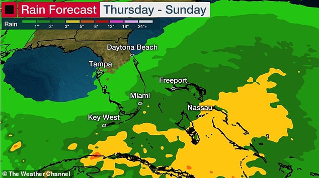
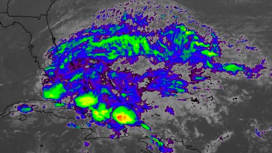
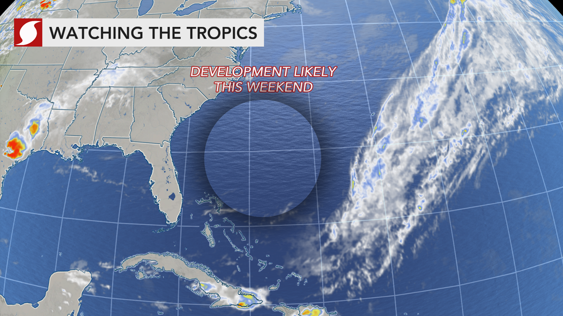
Even though the Atlantic hurricane season doesn't officially start until June 1, the first tropical or subtropical storm is expected to develop offshore of the southeastern United States this weekend.
"In every year since 2012, except for 2014, there has been at least one named tropical system during May," AccuWeather Senior Meteorologist Alex Sosnowski said - and this year is likely to be no different.
AccuWeather meteorologists anticipate a system to begin brewing near South Florida on Friday before strengthening into a subtropical or tropical system offshore of the Southeast coast this weekend. The ocean water is just warm enough for tropical development.
Hurricane season may get early start near southeast US
----------------------------
Here is the list of 2020 hurricane names:
Arthur
Bertha
Cristobal
Dolly
Edouard
Fay
Gonzalo
Hanna
Isaias
Josephine
Kyle
Laura
Marco
Nana
Omar
Paulette
Rene
Sally
Teddy
Vicky
Wilfred
Hurricane season names 2020 list: How Atlantic storms get their names
-------------------------
Colorado State University has released its early forecast for the 2020 Atlantic hurricane season. They have been issuing these early forecasts for almost 25 years. The CSU Atlantic hurricane season forecast calls for above average tropical weather activity.
Two of the main weather conditions CSU cites as reasons to expect more tropical systems and hurricanes this season also would influence Michigan and Ohio’s weather.
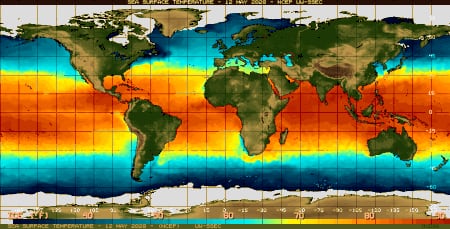
Sea surface water temperatures are warmer than normal around the southeast U.S. on May 13, 2020
CSU mentions a possible change from slight El Niño conditions to a possible La Niña developing this summer or fall. An El Niño produces a more west-to-east upper-level wind over the tropical Atlantic. The west-to-east wind can be a hinderance to hurricanes. The forecast of conditions turning to La Niña is an important one for hurricanes and Great Lakes weather. La Niña brings a more east-to-west upper air flow in the tropical Atlantic region. This condition helps hurricanes thrive, survive and move westward toward the U.S.
CSU also says surface water temperatures in the tropical Atlantic are warmer than normal for now. Of course we know the warmer ocean water could more easily brew a powerful hurricane.
Michigan, Ohio could see impact of new hurricane season forecast
-----------------------
Hurricane Season Is Expected to Be Particularly Active This Year, and Coronavirus Could Make It Worse
The start of the U.S. Atlantic hurricane season is just over two weeks away and forecasters are expecting particularly high activity this year. With warmer than usual conditions anticipated in the North Atlantic this summer, meteorologists have predicted that the season could produce eight or more hurricanes.
While forecasters cannot predict how many hurricanes—if any—will make landfall, the potential for dangerous storms to strike the southern and eastern coasts poses an additional problem for authorities already grappling with the COVID-19 pandemic.
Experts say that the pandemic is straining the capabilities of The Federal Emergency Management Agency (FEMA)—the government agency responsible for disaster coordination—and other organizations involved in responding to natural disasters
Hurricane season is expected to be particularly active this year, and coronavirus could make it worse
US weather: Hurricane season, wild winds and tornadoes expected | Daily Mail Online
Kristina Pydynowski
,
AccuWeather•May 13, 2020
Even though the Atlantic hurricane season doesn't officially start until June 1, the first tropical or subtropical storm is expected to develop offshore of the southeastern United States this weekend.
"In every year since 2012, except for 2014, there has been at least one named tropical system during May," AccuWeather Senior Meteorologist Alex Sosnowski said - and this year is likely to be no different.
AccuWeather meteorologists anticipate a system to begin brewing near South Florida on Friday before strengthening into a subtropical or tropical system offshore of the Southeast coast this weekend. The ocean water is just warm enough for tropical development.
Hurricane season may get early start near southeast US
----------------------------
Here is the list of 2020 hurricane names:
Arthur
Bertha
Cristobal
Dolly
Edouard
Fay
Gonzalo
Hanna
Isaias
Josephine
Kyle
Laura
Marco
Nana
Omar
Paulette
Rene
Sally
Teddy
Vicky
Wilfred
Hurricane season names 2020 list: How Atlantic storms get their names
-------------------------
Colorado State University has released its early forecast for the 2020 Atlantic hurricane season. They have been issuing these early forecasts for almost 25 years. The CSU Atlantic hurricane season forecast calls for above average tropical weather activity.
Two of the main weather conditions CSU cites as reasons to expect more tropical systems and hurricanes this season also would influence Michigan and Ohio’s weather.
Sea surface water temperatures are warmer than normal around the southeast U.S. on May 13, 2020
CSU mentions a possible change from slight El Niño conditions to a possible La Niña developing this summer or fall. An El Niño produces a more west-to-east upper-level wind over the tropical Atlantic. The west-to-east wind can be a hinderance to hurricanes. The forecast of conditions turning to La Niña is an important one for hurricanes and Great Lakes weather. La Niña brings a more east-to-west upper air flow in the tropical Atlantic region. This condition helps hurricanes thrive, survive and move westward toward the U.S.
CSU also says surface water temperatures in the tropical Atlantic are warmer than normal for now. Of course we know the warmer ocean water could more easily brew a powerful hurricane.
Michigan, Ohio could see impact of new hurricane season forecast
-----------------------
Hurricane Season Is Expected to Be Particularly Active This Year, and Coronavirus Could Make It Worse
The start of the U.S. Atlantic hurricane season is just over two weeks away and forecasters are expecting particularly high activity this year. With warmer than usual conditions anticipated in the North Atlantic this summer, meteorologists have predicted that the season could produce eight or more hurricanes.
While forecasters cannot predict how many hurricanes—if any—will make landfall, the potential for dangerous storms to strike the southern and eastern coasts poses an additional problem for authorities already grappling with the COVID-19 pandemic.
Experts say that the pandemic is straining the capabilities of The Federal Emergency Management Agency (FEMA)—the government agency responsible for disaster coordination—and other organizations involved in responding to natural disasters
Hurricane season is expected to be particularly active this year, and coronavirus could make it worse
US weather: Hurricane season, wild winds and tornadoes expected | Daily Mail Online
")