Madeleine McCann: German prisoner identified as suspect - #8

Status
Not open for further replies.
Could you possibly do the same with this one too, Photographer? Because with all the talk of a child in the other van, I think my brain is tricking me into thinking it can see one in this now o_O:confused: the back of a head, neck length hair, blue and white striped top??
I’m sure it’s not or wouldn’t have been released. It’s been a long day...:rolleyes:
It’s the rear window on these pics where I can see a girl standing, almost like that window has been photoshopped pre publication to hide her. I’m thinking I’m seeing things not there now though, but can someone humour me by taking a look please?!
 
Those van locations must be a gold key in MM's case.

Picture on the road is too difficult, but it must be on the way to the sea.

Sea picture is easier, and I guess it's Algarve, so I'm checking all Algarve coast in Google satellite. That cliff on the left and those rocks in front of van are clues.

Unfortunately there's no street view for that location.[/QUOTE
 
Yes. KM says that Cuddle Cat was up out of her daughter's reach where her daughter couldn't have put it and that is how she knew someone had taken her daughter. I had a few thoughts on this. Why would someone place cuddle cat there? This suggests to me that someone did this on purpose. Was it because the spot was easy for them to access? They'd have their hands full carrying the kid, and didn't want to bring something they might drop and leave behind? Was placing cuddle cat there a way to shush the child who may have woken: see dear? Cuddle Cat is just fine! Cuddle will watch from up here for a moment... and in that distracted moment, they grab her? It feels intentional. But why?
More likely to me that you’d put the toy out of the way to more easily pick up a sleeping child
 
I think the port is alvor the reflection of the statue in the window of the van looks like the fisherman sculpture in reverse on the seafront from a distance
 
The Algarve - Campervan Life

Barranco

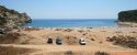
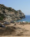
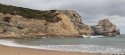
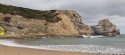
A beautiful, remote beach, down a very bad track. Barranco is a lovely bay, with a sandy beach, with rocky edges. Due to the poor access, many travellers stay here for a long time. The only locals you will ever see are the local surfers, and the goat farmer. It is possible to stay here during the summer months. The surf here is excellent. When the conditions are right you will see hoards of surfers, local and travelling, arrive in numbers. They will disappear as soon as the conditions change again. A right hand wave peels from one side of the bay to the other. Barranco is not signposted. To get there, from the N125 take the turning signposted for Praia da Ingrina and Praia do Zavial. The lane to Barranco is the first turning on the right. The lane is 3.5 miles (5.6 km) long, and not sealed. In some places massive pot holes fill with water. After heavy rains most vehicles will not be able to drive on the lane. 4WD vehicles should not have a problem.

Free camping at Praia do Barranco (Branco’s)
Barranco is a popular free camping area, throughout the year. However, access is along a long 3.5 mile (5.6 km) rutted track that can be a problem in wet weather. The bad lane means in summer you wont be moved on. There are bins at the beach, but nothing else. Take plenty of supplies with you. There is a little supermarket at theeceremonie turning on the N125.
it really looks like that is the place were the picture is taken of the van.
 

Attachments

  • praia-do-barranco-2.jpg
    praia-do-barranco-2.jpg
    92.1 KB · Views: 88
  • base-NINTCHDBPICT000587047327.jpg
    base-NINTCHDBPICT000587047327.jpg
    153.1 KB · Views: 84
I went a tour around Málaga on Google maps last night...

I think that first pic is roughly where CB was parked but I can’t seem to reach there via maps.
The second one is most of the structures you’ve pointed out, but taken from a different angle.

You too huh? Below is the closest I could get in recreating where CB's van would have been parked.
 

Attachments

  • Malaga.png
    Malaga.png
    676.9 KB · Views: 39
I think the port is alvor the reflection of the statue in the window of the van looks like the fisherman sculpture in reverse on the seafront from a distance
What photo is this referring to?
I've got very confused by the posts in the past few hours
 
Sorry if already covered but this is new (to me) in that they’re talking specifically about the mast. Anyone in the know - what’s the area-coverage of these things? Is it a dead cert that he was there or could he have been within a few miles?

“Mr Wolters said: "We know that the phone number which was used by our suspect on May 3, 2007, was connecting to the mast which belongs to the Ocean Club in Praia da Luz."

TV host Liz Hayes then presses the prosecutor on if they can place Christian B at the scene.

He replies: "Yes, we think so."”

Source: Phone call by Christian B 'made from outside resort where she was snatched'

Triangulation allows a fairly accurate location of a phone. (Phones rarely use just one tower if there are others within range. Basically, they gather the signal from three towers and see where they meet in the middle. Other variables are factored in as well.)

Also, strength of the phone's signal on the tower (mast) can give a fairly accurate distance of the phone from the tower.
 
Last edited:
You too huh? Below is the closest I could get in recreating where CB's van would have been parked.

Same! Very frustrating, I was so sure it would be easy to get to.

I wonder if anyone that’s handy with Google Earth can go back to 2007 and see how close they get?? The area may be more built up now than it was then - there were lots of structures and gated car parks around the port on the most recent Maps.
 
Last edited:

Attachments

  • van-sea-a.jpg
    van-sea-a.jpg
    133.2 KB · Views: 120
  • barranco-a.jpg
    barranco-a.jpg
    36.6 KB · Views: 121
  • van-sea-b.jpg
    van-sea-b.jpg
    133.5 KB · Views: 146
  • barranco-c.jpg
    barranco-c.jpg
    36.8 KB · Views: 113
Same! Very frustrating, I was so sure it would be easy to get to.

I wonder if anyone that’s handy with Google Earth can go back to 2007 and see how close they get?? The area may be more built up now than it was then - there were lots of structures and gated car parks around the port on the most recent Maps.


ETA Just noticing the Google 2012 stamp on those pics.
 
I cant enhance it any more can you see now
Triangulation allows a fairly accurate location of a phone. (Phones rarely use just one tower if there are others within range. Basically, they gather the signal from three towers and see where they meet in the middle. Other variables are factored in as well.)

Also, strength of the phone's signal on the tower (mast) can give a fairly accurate distance of the phone from the tower.
It could be the resorts internet, too.
If he ever used it then his phone would remember that.
Maybe this is what happened. Maybe when they questioned him in 2013 he said he wasn't there but then they got the logs from OC and they got his phone logged there.
This is just one of the possibilities.
 
It could be the resorts internet, too.
If he ever used it then his phone would remember that.
Maybe this is what happened. Maybe when they questioned him in 2013 he said he wasn't there but then they got the logs from OC and they got his phone logged there.
This is just one of the possibilities.

Yes, it is another possibility. Though I know that I read or heard on a MSM video that his phone was within 100 metres (or feet?) from the Ocean Club.
If I can ever remember where I saw or heard that, I will post the link.
 
Status
Not open for further replies.

Members online

Online statistics

Members online
197
Guests online
3,898
Total visitors
4,095

Forum statistics

Threads
591,831
Messages
17,959,757
Members
228,621
Latest member
Greer∆
Back
Top