Found Deceased Spain - Esther Dingley, from UK, missing in the Pyrenees, November 2020

Status
Not open for further replies.
So Esther was walking up past the refuge, as in the pictures attached, or did she come from the other side of the summit where she saw the skier? This is the part I’m struggling to visualise in my head, sorry I know I’m being a pain.
If she came up the opposite face, then in order to reach the refuge she had to clamber down snowy scree towards the lake and would then have to walk around to get to the refuge.
Pyrenees Post 9
 

Attachments

  • FBFE8EDC-AB32-4566-B648-15F302295227.jpeg
    FBFE8EDC-AB32-4566-B648-15F302295227.jpeg
    286.4 KB · Views: 59
  • 986D6C68-E7C1-4A52-AF24-4E72C69BFFAD.jpeg
    986D6C68-E7C1-4A52-AF24-4E72C69BFFAD.jpeg
    161.6 KB · Views: 46
Last edited:
Hmm, yes that is a bit more than I'd speculated ;)

I wasn't thinking that much into it, just wanting to make the point that I don't agree with everyone concluding no one else coulda been up there, just cos of what the skier guy said.
It's possible someone else was out hiking, but IMO not probable. Not just because of the skier, but also because of the time of year, the time of day, the lockdowns, etc. But I agree nothing can be ruled out at this point.
 
<modsnip: Quoted post was removed by member>

It’s been a long long time since I’ve hiked and I have not ever hiked the Pyrenees but I have climbed scree many a time where the path isn’t clear and even well placed feet can slip (particularly with a weight in your back), although on the same score I feel sure they would have at least checked that specific lake. Thanks for clarifying which way she was coming though.
 
Last edited by a moderator:
The photos posted show the spectacular beauty of the mountains, but they are also terrifying. Alone, late on a November afternoon, even a minor mishap might have left her in pain and disoriented as night fell. She might have fallen, been knocked out for a bit, come to in pain...and been unable in the dark to find her way to the refuge. She might have staggered anywhere.

And even if the initial accident was minor...it was almost three days before she was reported missing.

All the aspects of hiking that area...alone...during the Pandemic...the solitude, the rugged terrain that afforded a sense of achievement, the freedom and independence ...all those aspects that she found most appealing...are also the same ones that left her most vulnerable...even if the initial “problem” was relatively minor.
 
Here is an account of the route up Pic de Sauvegarde:

Pyrenees

"The descent from the summit is the same as the way up, including the traverse using the cable, whic is not that scary on the way back. " (go to page 2, post 21)

Combined with the maps showing Sauvegarde as an offshoot of the loop, it seems clear that there is one path up and down, rather than being able to go up and over. Esther did not have to climb Sauvegarde to get where she was going, it was an optional activity on the route.

It also makes sense that the Olympian knew that there was nobody else up there as he would be able to see any other hikers descending behind him, and he had not passed anyone else going up as he was walking down.
 
Last edited:
Here is an account of the route up Pic de Sauvegarde:

http://www.walkingforum.co.uk/index.php?PHPSESSID=1nomoddq3ten8ce58pf00n6qt4&topic=40054.15

"The descent from the summit is the same as the way up, including the traverse using the cable, whic is not that scary on the way back. "

Combined with the maps showing Sauvegarde as an offshoot of the loop, it seems clear that there is one path up and down, rather than being able to go up and over. Esther did not have to climb Sauvegarde to get where she was going, it was an optional activity on the route.

It also makes sense that the Olympian knew that there was nobody else up there as he would be able to see any other hikers descending behind him, and he had not passed anyone else going up as he was walking down.
I'm just getting an error message on your link.
 
The man who gave her a lift, saw her on the day before.

RSBM

I haven't been following that angle of the driver, I didn't realize this, thanks. Talk about red herrings!

November 19. After staying at a friendly hostel somewhere, and a few days trekking in solitude/snowy conditions, got a lift back to her van in Benasque by a fellow hiker
*Confusion #1: who was this person, did he mean her harm, where is he now?*

November 19-21. Hanging out in Benasque.
Uploaded the last bit about her trek to SM.
*Confusion #2: was this the trek she was on when she disappeared?*
Chia/yoga sightings.

Nov 21. Got a lift from a Spanish driver to the trailhead for Port Venasque.
*Confusion #3: She was supposed to be heading to Port de la Glere per the previous reporting!...Did she tell this man the secrets of her life?*

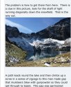
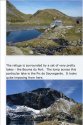
From there, hiked up the peak of Sauveguard and returned the way she came, back to the van in Benasque. Posted photos online.
*Confusion #4: were these the photos of the day she went missing? Why are they dated November 21, when she went missing on the 22nd?*

Talked to father, partner, and did various other things to prepare for a longer hike along that route.

Nov. 22. Set off on a 3 day trek with full backpacking gear, along a circle route that would pass into France (stay at the Refuge Venasque on her first night), continue through France to a different border crossing, and then back to her camper van in Benasque.

Took a side trip to hike again to the peak of Sauveguard. Was seen (1 hour before she reached the peak) by a hiker and his companion, probably near the pass at Port de Venasque, which is about 1 hour from the peak for a fit hiker. The witnesses continued downhill back to Benasque, as they were on a day hike. Esther intended to head downhill in the opposite direction, into France.

Sent a message to her partner when she reached the peak at 4 pm.
*Confusion #4 again: are the photos online really the photos of her at the peak at 4 pm on the 22nd, or are they photos from the previous day's hike, the 21st, that she had posted to SM and sent to her partner?

Then: No witnesses, no cellphone signals, no evidence as to what happened to her after that point.

IMO, regarding the 4 confusions:
#1: the previous hiker is IMO irrelevant, she'd met him several days earlier.
#2: the post on the 19th is IMO irrelevant, this was a completely different route from the one she was on when she disappeared.
#3: what route was she on and when did she start? IMO, the trek started Nov 22, she was to return on the 25. She was on a loop into France and back into Spain, via two different mountain passes.
#4: IMO, the photos were all taken on the 21st, a day hike to the peak where she took lots of photos. I'm not sure whether she took any photos on the 22nd. Possibly she just sent Colegate a text message, but he shared the photo from the previous day so people who might have seen her would know what she looked like.
 
Last edited by a moderator:
Excuse my crap photo of my laptop screen, and wonky writing (a technical whizz I am not!). I think this was her planned route.

A - Plan d’Estan where she was dropped off the previous day (and maybe returned to sleep - unconfirmed)

B - Port de Venasque which is the cut through, or “doorway” through the mountains. Fun fact: This was detonated with explosives to form a trading route between France and Spain.

C - Pic de Sauvegarde where Esther was last known to be. She’d have to climb up to the peak and back down the same way to the doorway at B to continue the trail.

D - Refuge de Venasque where Esther was planning to stay that first night.

E - Pic de la Glere, the last stop on her plan having followed an anti-clockwise loop.

F - Llanos del Hospital is a ski resort where I think she would have ended her trip, before getting a lift back to her van in Benasque.

4FA814A6-DDBD-4B98-88EF-2A85A9A541E4.jpeg
 
Last edited:
Yes, and the maps make this clear. So I'm really confused why people are saying there was more than one route and therefore someone could have approached her from the other side.

Are we just all really confused? :Do_O:confused:
My confusion is seeing the summit as a side trip, a side trail to the summit from the main trail. So she hiked up the main trail, then took the side trail up to the summit, then came back down the same side trail, then continued on the main trail. The main trail would have gone downhill to the refuge. So the main trail went up, the side trail continued upward to the summit, the main trail went downhill beyond the side trail.o_O:confused::eek:

So it is possible (although IMO not likely) someone could have been coming from the opposite direction on the main trail.
 
Status
Not open for further replies.

Staff online

Members online

Online statistics

Members online
209
Guests online
3,811
Total visitors
4,020

Forum statistics

Threads
591,818
Messages
17,959,559
Members
228,620
Latest member
ohbeehaave
Back
Top