
Install the app
How to install the app on iOS
Follow along with the video below to see how to install our site as a web app on your home screen.
Note: This feature may not be available in some browsers.
You are using an out of date browser. It may not display this or other websites correctly.
You should upgrade or use an alternative browser.
You should upgrade or use an alternative browser.
WV WV - Cassie Shelton Sheetz, 23, hiker, Spruce Knob, Monongahela National Forest, 11 Mar 2021
- Thread starter BadRx
- Start date
worm
Well-Known Member
- Joined
- Apr 30, 2020
- Messages
- 2,912
- Reaction score
- 21,797
Cassie's case has slid off msm. Disinterest or the calm before the storm?
Surely they have combed that area by now. Hopefully your 2nd guess is correct.
A bit of both, I think.....Cassie's case has slid off msm. Disinterest or the calm before the storm?
shotgun09
'Certified' Boomer
- Joined
- Dec 28, 2009
- Messages
- 3,734
- Reaction score
- 37,071
Cassie's case has slid off msm. Disinterest or the calm before the storm?
Ha! I agree with a little of both, along with the locals and their mud slinging slowing down abit. Where is Cassie?
I think this will go the way of Jessica Stacks: it's pretty obvious the men involved are lying, but without evidence or a body, LE has little to go on.Cassie's case has slid off msm. Disinterest or the calm before the storm?
mlhenn
Well-Known Member
- Joined
- Jul 11, 2019
- Messages
- 15,633
- Reaction score
- 70,811
The National Missing and Unidentified Persons System (NamUs)
Cassie Renee Sheetz

5’3”
120 lbs
24 yr old female
Circumstances of Disappearance
Cassie Renee Sheetz was last seen on Friday March 12, 2021, around midnight, at the top of Spruce Knob, which is located in the Monongahela National Forest, in Pendleton County, WV.
Cassie and two male companions were starting down Huckleberry Trail, after reaching the top of Spruce, when the group became separated, around midnight.
At different times, in the morning hours of Saturday March 13th, both males walked out of the woods, the authorities were eventually notified and the search for Cassie began.
Cassie has not been seen or heard from since Friday.
At the time of her disappearance, it believed that Cassie was wearing camouflage pants and a hoodie.
Cassie Renee Sheetz
5’3”
120 lbs
24 yr old female
Circumstances of Disappearance
Cassie Renee Sheetz was last seen on Friday March 12, 2021, around midnight, at the top of Spruce Knob, which is located in the Monongahela National Forest, in Pendleton County, WV.
Cassie and two male companions were starting down Huckleberry Trail, after reaching the top of Spruce, when the group became separated, around midnight.
At different times, in the morning hours of Saturday March 13th, both males walked out of the woods, the authorities were eventually notified and the search for Cassie began.
Cassie has not been seen or heard from since Friday.
At the time of her disappearance, it believed that Cassie was wearing camouflage pants and a hoodie.
I'm not sure if I was aware that Cassie was supposedly wearing camouflage at midnight while hiking in the woods. Just adds another layer of incredulous head shaking to this case.The National Missing and Unidentified Persons System (NamUs)
Cassie Renee Sheetz
View attachment 289934
5’3”
120 lbs
24 yr old female
Circumstances of Disappearance
Cassie Renee Sheetz was last seen on Friday March 12, 2021, around midnight, at the top of Spruce Knob, which is located in the Monongahela National Forest, in Pendleton County, WV.
Cassie and two male companions were starting down Huckleberry Trail, after reaching the top of Spruce, when the group became separated, around midnight.
At different times, in the morning hours of Saturday March 13th, both males walked out of the woods, the authorities were eventually notified and the search for Cassie began.
Cassie has not been seen or heard from since Friday.
At the time of her disappearance, it believed that Cassie was wearing camouflage pants and a hoodie.
mlhenn
Well-Known Member
- Joined
- Jul 11, 2019
- Messages
- 15,633
- Reaction score
- 70,811
The timeline is confusing IMO...so many different dates, times, etc...
https://wvmetronews.com/2021/03/17/woman-remains-missing-in-spruce-knob-area/
...went hiking with two male friends last Thursday evening
One of the males spoke with Teter and other law enforcement on Friday. The second man walked out as search teams were assembling to look for the individuals. Sheetz’s family claim they were told the group became separated Thursday night, but Cassie wasn’t reported missing until Friday.
...look for the missing woman on Saturday.
Family searching for missing hiker near Spruce Knob
...police notified the family that the group of hikers was split up around midnight on Thursday.
MISSING: WV State Police look for woman last seen at Spruce Knob | WOWK 13 News
Cassie Renee Sheetz who was last seen on Friday, March 12 around 10:00 p.m.
became separated from the group around midnight.
Both males found their way out of the woods early in the morning on Saturday, March 13
Once authorities were notified, a search began.
Woman missing after hiking in Spruce Knob | WBOY.com
went hiking on the Huckleberry Trail area of Spruce Knob in Pendleton County on Mar. 11.
was officially listed as missing on Mar. 12
The National Missing and Unidentified Persons System (NamUs)
Date Last Contact: March 12, 2021
last seen on Friday March 12, 2021, around midnight
At different times, in the morning hours of Saturday March 13th, both males walked out of the woods, the authorities were eventually notified and the search for Cassie began.
Cassie has not been seen or heard from since Friday.
Curious_in_NC
Well-Known Member
- Joined
- Aug 14, 2020
- Messages
- 1,319
- Reaction score
- 8,649
@mlhenn, Thanks very much for summarizing the, um, confusion about this from MSM.The timeline is confusing IMO...so many different dates, times, etc...
https://wvmetronews.com/2021/03/17/woman-remains-missing-in-spruce-knob-area/
Woman remains missing in Spruce Knob area - WV MetroNews
...went hiking with two male friends last Thursday evening
One of the males spoke with Teter and other law enforcement on Friday. The second man walked out as search teams were assembling to look for the individuals. Sheetz’s family claim they were told the group became separated Thursday night, but Cassie wasn’t reported missing until Friday.
...look for the missing woman on Saturday.
Family searching for missing hiker near Spruce Knob
...police notified the family that the group of hikers was split up around midnight on Thursday.
MISSING: WV State Police look for woman last seen at Spruce Knob | WOWK 13 News
Cassie Renee Sheetz who was last seen on Friday, March 12 around 10:00 p.m.
became separated from the group around midnight.
Both males found their way out of the woods early in the morning on Saturday, March 13
Once authorities were notified, a search began.
Woman missing after hiking in Spruce Knob | WBOY.com
went hiking on the Huckleberry Trail area of Spruce Knob in Pendleton County on Mar. 11.
was officially listed as missing on Mar. 12
The National Missing and Unidentified Persons System (NamUs)
Date Last Contact: March 12, 2021
last seen on Friday March 12, 2021, around midnight
At different times, in the morning hours of Saturday March 13th, both males walked out of the woods, the authorities were eventually notified and the search for Cassie began.
Cassie has not been seen or heard from since Friday.
worm
Well-Known Member
- Joined
- Apr 30, 2020
- Messages
- 2,912
- Reaction score
- 21,797
To the locals who hike the area, it the terrain there like most of the entire range, dangerous with drop offs and such? I’m only familiar with the Carolinas mountains where hiking at night is often deadly and visibility isn’t great even in daylight. If these kids aren’t experienced, it’s possible that they got in trouble fast but things aren’t adding up.
mlhenn
Well-Known Member
- Joined
- Jul 11, 2019
- Messages
- 15,633
- Reaction score
- 70,811
They were all split up in the woods just before dark on Thursday (18.00hrs approx).
A passing vehicle finally went past where their car was parked at 11.00hrs Friday and the 2 men flagged it down for help.
But before that, they had both waited at their car for 3 hours together for Cassie. (So, since 08.00hrs)
But one of the men, who came out of the woods first (and smashed the back window in to get inside the car) had been at the car for 2 hours before the other man (so 06.00hrs).
So, from that timeline they had all split up and been wandering around the woods, lost and or looking for Cassie for 12 hours!! (18.00hrs Thursday to 06.00hrs Friday). Then waiting at the car for some more hours! (5 hours for one man, 3 hours for the other.)
Wow, 12 hours in the woods in the dark?! Were they searching for her that whole time? They'd been hiking all day too. What about sleep? Tiredness? Enough battery power in the flashlights? Did they shout or call out to Cassie? Did Cassie shout out to them?
Then finally stopped a passing car at 11.00hrs Friday. and when you add in that they started this hike in the daytime on Thursday....it's getting on for a whole 24 hour job!! That's a long time to be up there.
Those 2 men need to be hauled in by LE and interrogated!
Plus, local search teams have had sniffer dogs there who couldn't find Cassies's scent, which makes me question if she was even up there at all.
MOO.
Is there a link to support this? I went back and reread prior posts & articles, but I may have missed it.

I just feel like what info that has been shared is really confusing at this point; I’m just trying to make sense of what’s fact vs speculation.
mlhenn
Well-Known Member
- Joined
- Jul 11, 2019
- Messages
- 15,633
- Reaction score
- 70,811
WV ManTrailing Bloodhounds | WV ManTrailing Bloodhounds Search Group
Shared a couple posts with photos from their search for Cassie at Spruce Knob.
Shared a couple posts with photos from their search for Cassie at Spruce Knob.
mlhenn
Well-Known Member
- Joined
- Jul 11, 2019
- Messages
- 15,633
- Reaction score
- 70,811
The Pendleton Times
The Pendleton Times Newpaper’s Facebook page has a few posts on Cassie’s disappearance.
A long “trail” of comments...
The Pendleton Times Newpaper’s Facebook page has a few posts on Cassie’s disappearance.
A long “trail” of comments...
Last edited:
worm
Well-Known Member
- Joined
- Apr 30, 2020
- Messages
- 2,912
- Reaction score
- 21,797
The Pendleton Times
The Pendleton Times Newpaper’s Facebook page has a few posts on Cassie’s disappears.
A long “trail” of comments...
I don’t have FB but I can imagine.
FutureMrsD
Member
- Joined
- May 19, 2020
- Messages
- 5
- Reaction score
- 69
Mr. D and I found ourselves rerouted by GPS last summer and ended up driving straight through the forest to get back home. We are Verizon users - we had service upon entering, intermittently at higher points but mostly without service. I felt so disconnected, even GPS struggled. The area is beautiful but very shrouded and overall just gave me a creepy and uncomfortable feeling.
I also desperately had to pee and we stopped right beside the large MONONGAHELA NATIONAL FOREST sign. I scoped out the area a bit to make sure I wasn’t doing my thing for an audience. The terrain seemed uneven and visibility wasn’t terrific.
I’m concerned if Cassie was really there, it may be difficult to find her and I’m not sure cell data from anyone will be a huge help.
mlhenn
Well-Known Member
- Joined
- Jul 11, 2019
- Messages
- 15,633
- Reaction score
- 70,811
The AWARE Foundation, Inc.
March 25
The search for Cassie Sheetz continues. Cassie’s dad, family, and friends will be searching the Spruce Knob area on Saturday, March 27, 2021. If anyone would like to join the search, it will be appreciated. It will begin between 10 & 11 am.
March 25
The search for Cassie Sheetz continues. Cassie’s dad, family, and friends will be searching the Spruce Knob area on Saturday, March 27, 2021. If anyone would like to join the search, it will be appreciated. It will begin between 10 & 11 am.
Curious_in_NC
Well-Known Member
- Joined
- Aug 14, 2020
- Messages
- 1,319
- Reaction score
- 8,649
Hi @worm, I was curious about this too and, even though I'm not local, I looked into this. If someone local thinks my impressions here are wrong, please say so.To the locals who hike the area, it the terrain there like most of the entire range, dangerous with drop offs and such? I’m only familiar with the Carolinas mountains where hiking at night is often deadly and visibility isn’t great even in daylight. If these kids aren’t experienced, it’s possible that they got in trouble fast but things aren’t adding up.
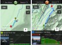
Spruce Pine Knob looks like a lot of state high points. Like Mt Mitchell in NC, Mt. Rogers in VA, and Mt. Mansfield in VT, you can drive to near the summit, park, and easily walk to the top. Or you can take the "hard" route and hike to the top by any number of trails. It looks like the summit trail from the Spruce Knob parking lot to the observation deck is a relatively flat gravel road about 0.2 miles long. Whether or not one were under the influence of anything, this would probably be do-able at night.
On the other hand, if the group thought that was too easy and wanted more challenge, they would have crossed the parking lot to the Huckleberry Trail, the "hard" route. The Hiking Project App has this review: "This trail begins at Spruce Knob and goes through dense forest. It is rocky most of the way, and you can expect muddy/marshy areas after heavy rains." It drops almost 900' over 4.8 miles. It looks like a pretty steep dropoff near the southeast side of the trail. So yes, it sounds as difficult and as dangerous at night as many western NC trails.
A map of the trails with the Spruce Knob section magnified on the left and the Huckleberry Trail on the right:
Attachments
worm
Well-Known Member
- Joined
- Apr 30, 2020
- Messages
- 2,912
- Reaction score
- 21,797
@Curious_in_NC , thank you for the information and your reply. <modsnip> Those trails look ok but as @FutureMrsD mentions, a quick bathroom break just yards from a trail in dim light could be a serious mistake.
Last edited by a moderator:
Limecat
Lime + Cat = Limecat
- Joined
- Nov 5, 2011
- Messages
- 1,715
- Reaction score
- 12,737
Thank you! Great informationHi @worm, I was curious about this too and, even though I'm not local, I looked into this. If someone local thinks my impressions here are wrong, please say so.
Spruce Pine Knob looks like a lot of state high points. Like Mt Mitchell in NC, Mt. Rogers in VA, and Mt. Mansfield in VT, you can drive to near the summit, park, and easily walk to the top. Or you can take the "hard" route and hike to the top by any number of trails. It looks like the summit trail from the Spruce Knob parking lot to the observation deck is a relatively flat gravel road about 0.2 miles long. Whether or not one were under the influence of anything, this would probably be do-able at night.
On the other hand, if the group thought that was too easy and wanted more challenge, they would have crossed the parking lot to the Huckleberry Trail, the "hard" route. The Hiking Project App has this review: "This trail begins at Spruce Knob and goes through dense forest. It is rocky most of the way, and you can expect muddy/marshy areas after heavy rains." It drops almost 900' over 4.8 miles. It looks like a pretty steep dropoff near the southeast side of the trail. So yes, it sounds as difficult and as dangerous at night as many western NC trails.
A map of the trails with the Spruce Knob section magnified on the left and the Huckleberry Trail on the right:
Curiousobserver
Well-Known Member
- Joined
- Sep 14, 2018
- Messages
- 2,374
- Reaction score
- 26,561
Sounds like they did try and descend via the more difficult trailHi @worm, I was curious about this too and, even though I'm not local, I looked into this. If someone local thinks my impressions here are wrong, please say so.
Spruce Pine Knob looks like a lot of state high points. Like Mt Mitchell in NC, Mt. Rogers in VA, and Mt. Mansfield in VT, you can drive to near the summit, park, and easily walk to the top. Or you can take the "hard" route and hike to the top by any number of trails. It looks like the summit trail from the Spruce Knob parking lot to the observation deck is a relatively flat gravel road about 0.2 miles long. Whether or not one were under the influence of anything, this would probably be do-able at night.
On the other hand, if the group thought that was too easy and wanted more challenge, they would have crossed the parking lot to the Huckleberry Trail, the "hard" route. The Hiking Project App has this review: "This trail begins at Spruce Knob and goes through dense forest. It is rocky most of the way, and you can expect muddy/marshy areas after heavy rains." It drops almost 900' over 4.8 miles. It looks like a pretty steep dropoff near the southeast side of the trail. So yes, it sounds as difficult and as dangerous at night as many western NC trails.
A map of the trails with the Spruce Knob section magnified on the left and the Huckleberry Trail on the right:
MISSING: WV State Police look for woman last seen at Spruce Knob | WOWK 13 News
DNASolves
Online statistics
- Members online
- 121
- Guests online
- 4,165
- Total visitors
- 4,286
Totals may include hidden visitors.