Did the sheriff specify what tool Jon used to map the waypoints? (Google?)
He just said it was "an app." Could be AllTrails or something like it.

Did the sheriff specify what tool Jon used to map the waypoints? (Google?)
S
So maybe that’s what Jon and Ellen intended to do?
I think the “more” that people want to know is actually the WHY, and we will never know.
Why they decided to hike on a day with a brutal heat forecast, why they didn’t take proper supplies and wear appropriate clothing, why they didn’t turn around and return to the car.
The “why” will never, can never, be known.

Snipped for focusNow, however, I’m confused about the backpack(s). I was led to believe there was a single super-duper child carrier/85 oz hydration pack combo. Don’t think so. No such beast exists, does it? Must be, IMO, a separate carrier (a luxe model as depicted on the private IG, the last known contact on original timeline) and 85 oz (standard large, from 2.5 L) hydration pack. The Sheriff said ‘Camelbak’ but he may have been using an eponym. At any rate, Camelbak does not make carriers afaik.
Average 2 mph. On the easy bits, quite a bit faster, but those switchbacks are a brutal haul, and you'd be tired.Say you were fit, the temperature was a steady 74°F, hydrated and had everything required for the hike, how long do you think it may take to hike that loop?
I’m not sure there’s a real complicated reason they kept going and didn’t turn around. They could have been having a really interesting conversation, warm but not too hot, going down is easy and sometimes if you’re talking or whatever you can just easily keep going down without thinking about it. Who knows maybe they were arguing or trying to keep the baby distracted. Maybe they were just the kind of people who ALWAYS finish what they start. I’ve made myself finish books that I absolutely hated just because I hate to leave a book halfway read, you know? I guess I can understand that there was a “plan” and it needed to be finished. Nobody really thinks the worst is going to happen. They probably just thought they might be really hot, but at least they would complete the hike as intended. Then going up the reality slapped them in the face, but up was the only way home.BBM
What you stated (in bold) here is the REAL WHY for me. They took the hike in the first place believing it would be interesting and *exhilarating* (an adventure). So the real question for me is WHY didn't they abort the hike and turn around when things got *uncomfortable*. To me that should have taken place at Marble point before the leg down to the river. MOO
Yes, Jon and Ellen could have intended just to look around or walk about when they drove to the trailhead. That’s possible.S
So maybe that’s what Jon and Ellen intended to do?
Great job with this!Well, I had a whole multi-quote response post planned but alas, as our thread switched pages, I lost my draft quotes, so I'll let that intent go.
Instead, I'll share some lessons learned from this poor family, as I try to let go of the "WHY" question. My thinking here is akin to training programs (e.g. emergency responses) in which you run scenarios to prepare your mind to make good decisions when under high stress - trained to think through options when in crisis.
Purposely, I am not addressing lessons learned about preparing for a hike. But rather, this is intended to prepare for and manage a crisis of a hike when it unfolds.
1. Be constantly vigilant with regards to the welfare, needs and best recourse to protect animal or human dependent(s), as they are the most vulnerable.
2. Speak up and don't be shy to say 'help!' when you or any member of your hiking or traveling party starts to feel at all 'off' (e.g. lightheaded, fatigued, winded.)
3. Stop and evaluate the situation at the first signs of a crisis, while you still have all your faculties, so you can clearly consider options and make decisions.
4. Always be prepared to turn around or change course to seek shelter, rescue, water, etc. at a moment's notice, which will likely mean giving up on your 'goals'.
5. Even if one of your party is uncomfortable with respect to secondary needs (e.g. food), you must always prioritize the most critical needs (e.g. shelter from elements).
6. It is important to be able to let go of social norms if necessary to survive, even if that means sitting in a river overnight until you are rescued during extreme heat.
7. If possible, send the most able of your party on / back alone in order to seek help and rescue, especially when others in the party are more compromised.
8. If one or more of your hiking party becomes gravely incapacitated and others face the same risk, leave the gravely ill behind in order to save the remaining lives.
9. If a member of your hiking party dies while hiking, and others face the same risk, try not to let the profound grief or guilt get in the way of saving your self or others.
10. Assign the most experienced and fit member of the hiking party to be the captain of an outing so there is a single arbiter to make decisions when in a crisis.
Of course all this is easier said than done. Some of these lessons even appear unconscionable to me sitting comfortably at my desk. But I'd like to think in an unfolding crisis like JG/EC faced that Sunday, their experiences and failings have helped prepare me and hopefully others to avoid the same mistakes in order to save lives.
Some comments made by the Mariposa County Sheriff’s FB page:
imgur.com
“What we know about Oski is that he was 8 years old, had very thick fur and went on a very strenuous hike in very hot weather. We don't know what kind of access to water he had, we don't know if he ever drank from the river and we don't know if the family shared any of their water supply with him.
But not where on the trail.
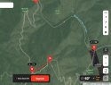
Held back a chuckle yesterday when the Sheriff referenced Hites Coves trails, stumbled, then said, ‘The whole area is Hites Cove.’Thanks to @Pumphouse363 now we know Jon used onXmaps.com. I joined and used on my laptop. It's a great mapping site that I'm sure works much better as an app.
The loop is very clear. In fact, it's the clearest map of the trail I've seen of the area. (not great for topography or for capturing elevations. The image seems very flat to me.) The trail distances indicated once I added waypoints. There is another tool that will give line distances. Elevations are readily available. The maps can also be saved and used offline. So we now know Jon had absolutely no confusion about the trails. In fact, I believe the map used in the LE presentation was from onXmaps.
The naming is confusing but the mapping is not. The area maps itself. A river flows from east-west at the bottom of a canyon flanked by two steep ridges on the north and south. There can be no confusion about up/down stream or up/down hill and the trails do not require route-finding.
I’m not sure there’s a real complicated reason they kept going and didn’t turn around. They could have been having a really interesting conversation, warm but not too hot, going down is easy and sometimes if you’re talking or whatever you can just easily keep going down without thinking about it. Who knows maybe they were arguing or trying to keep the baby distracted. Maybe they were just the kind of people who ALWAYS finish what they start. I’ve made myself finish books that I absolutely hated just because I hate to leave a book halfway read, you know? I guess I can understand that there was a “plan” and it needed to be finished. Nobody really thinks the worst is going to happen. They probably just thought they might be really hot, but at least they would complete the hike as intended. Then going up the reality slapped them in the face, but up was the only way home.
Very good, nice work putting that together. One of the problems that is difficult to surmount is the perception of relative risk. I wouldn't think twice about using the river water for cooling, or even drinking in an emergency like this. (I ran out of water and drank creek water once in desperation, before a hot, steep climb to my car. A "lite" version of this incident.) But if you read the signs about toxic algae you could think it would be a death sentence. However, as the sheriff said, no human has died (or so few it's uncertain) in the USA from toxic algae. People were swimming (dare I say frolicking?) in the river along Hwy 140 that day. We can't know why, but they didn't use the river water, which would have saved their lives. You have to rationally assess relative risk. Easier said than done.Well, I had a whole multi-quote response post planned but alas, as our thread switched pages, I lost my draft quotes, so I'll let that intent go.
Instead, I'll share some lessons learned from this poor family, as I try to let go of the "WHY" question. My thinking here is akin to training programs (e.g. emergency responses) in which you run scenarios to prepare your mind to make good decisions when under high stress - trained to think through options when in crisis.
Purposely, I am not addressing lessons learned about preparing for a hike. But rather, this is intended to prepare for and manage a crisis of a hike when it unfolds.
1. Be constantly vigilant with regards to the welfare, needs and best recourse to protect animal or human dependent(s), as they are the most vulnerable.
2. Speak up and don't be shy to say 'help!' when you or any member of your hiking or traveling party starts to feel at all 'off' (e.g. lightheaded, fatigued, winded.)
3. Stop and evaluate the situation at the first signs of a crisis, while you still have all your faculties, so you can clearly consider options and make decisions.
4. Always be prepared to turn around or change course to seek shelter, rescue, water, etc. at a moment's notice, which will likely mean giving up on your 'goals'.
5. Even if one of your party is uncomfortable with respect to secondary needs (e.g. food), you must always prioritize the most critical needs (e.g. shelter from elements).
6. It is important to be able to let go of social norms if necessary to survive, even if that means sitting in a river overnight until you are rescued during extreme heat.
7. If possible, send the most able of your party on / back alone in order to seek help and rescue, especially when others in the party are more compromised.
8. If one or more of your hiking party becomes gravely incapacitated and others face the same risk, leave the gravely ill behind in order to get help to save all.
9. If a member of your hiking party dies while hiking, and others face the same risk, try not to let the profound grief or guilt get in the way of saving your self or others.
10. Assign the most experienced and fit member of the hiking party to be the captain of an outing so there is a single arbiter to make decisions when in a crisis.
Of course all this is easier said than done. Some of these lessons even appear unconscionable to me sitting comfortably at my desk. But I'd like to think in an unfolding crisis like JG/EC faced that Sunday, their experiences and failings have helped prepare me and hopefully others to avoid the same mistakes in order to save lives.
The blog by a woman who started down the Hite's Cove trail a couple of years ago with a friend and friend's dog really brought home the point about being willing to turn around and forfeit your goal, if the situation starts looking dicey. Her friend said, on their way down, that she was worried there wasn't enough water for the dog. She wanted to turn around. The blogger said, she'd never quit a hike. She wanted to keep going, but in the end, respected her friend's concern for the dog.BBM
It's a matter of THRESHOLD. What circumstances would have to occur for them to abort and turn around? If there was a fire near a portion of the trail, would THAT be enough to convince them to turn back? Certainly there would be some conditions or events that would convince them to do so. Apparently, there was nothing in the first 2 miles going down the trail that was sufficient to trigger a threshold of impending danger. Now, as far as the "reality of going back up being a slap in the face".....certainly this would be no surprise to JG. It's fundamental to the nature of this hike. What goes down must come back up. SIMPLE. It's hard to imagine that by the time they made it to the river, that they didn't have some issues with heat and stress with baby and dog. Yet, they decided to hike another 5 miles rather than back up HC Road for 2 miles. Certainly JG understood that ultimately there is no *FREE LUNCH* going back up. Hiking an ADDITIONAL 3MILES is time consuming. Exposure to HEAT is increasing over time and the clock is ticking.
I find it remarkable that the urge to finish the plan would trump the difficulties that certainly confronted them when they made it down to the river on HC Road. We'll never know what was in their mind at that juncture, but I doubt they were having a pleasant time. MOO
I’d be interested to know the details of the investigation, but I think that’s up to the families if they care to share them.
Sheriff Briese gave a long and extensive list of experts that worked on this case for two months.
JG mapped the route, SAR tracked the family on it: the loop is not in dispute. They chose not to share all the details of their investigation, but mentioned the families were fully informed.