Hurricane Ian, Sept 2022


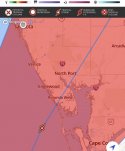
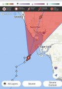
The storm, which is just short of the 157-mph threshold for Category 5 strength, is expected to make landfall late Wednesday morning or early in the afternoon in an area running from just south of Fort Myers to just north of Sarasota, according to a 8 a.m. update from the National Hurricane Center.

The new estimates call for a storm surge of 12-18 feet from Englewood and Charlotte Harbor to south of Fort Myers. A broader area, running from north of Englewood to north of Sarasota, could experience a storm surge of eight to 12 feet.

1664373912808.jpeg
 
Checking in from Sarasota.

My youngest has lost power where she is sheltering out west of I-75 off Bee Ridge Rd. That is in the west central Sarasota area. They're in a concrete house but no window shutters or plywood. The bathroom tile walls and tub is their only serious shelter option. Her boyfriends mother didn't think the storm would be this bad. She's a school teacher, how the heck did she miss this coming? <insert eye roll>

My oldest is in North Port, about 30 minutes south of Sarasota and the eye appears as if it will cross right over her about 3:00pm. They are in a concrete house with hurricane shutters. Their 2 vehicles in the garage. My truck is in their driveway and one of the FWC's big SUVs is in the driveway. They can go to the FWC office because it has a generator and locker rooms to shower.

The biggest factor will be road debris. This morning I went over to my friends Dads place to pick up an impact drill. Not that I will be able to get the bolts in and shutters up at this point. Along the way I dodged small debris like pine needles, pine cones, small branches, and palm fronds. I always try to drive around these items. Palm frond thorns will puncture a tire. I forgot to pick up a few cans of Fix A Flat.

I still have power and internet but that will not likely last. I have every portable charger plugged in. My neighbor has brand new hurricane windows and invited me to shelter with them. My windows are double-paned so that does offer more hurricane protection.

I have small tree debris like dead limbs and leaves from the two big oak trees out back. The wind whistles are more frequent and the trees are really swaying now. The rain is blowing sideways and changes directions at times.
Thank you for your up-to-the-minute reports. I hope that you and your daughters and other family members will be safe. Some of our neighbors and former neighbors have condos in the general area of the storm (Naples, Venice, Sarasota). I'm sure they are concerned about damage to their various properties. Please stay safe.
 
Prayers for anyone in the path of this awful storm.

We have been vacationing in Sanibel for over 30 years. It is poised to take a direct hit, storm is almost a cat5. IMO parts of Captiva will cease to exist.

Best broadcast storm coverage (better than TWC).

Sanibel has lost power. Webcam at Naples pier is still working.

Take care all
 

Water along the Hillsborough River in downtown Tampa started receding Wednesday morning as Hurricane Ian approached the southwest coast of Florida.

Around the same time, officers with the Tampa Police Department posted several photos of water receding from the bay along Bayshore Boulevard.

“The water has receded, a clear sign that Hurricane Ian is drawing near,” the department said.

Water was also being pushed out on the other side of the bay. WFLA Photojournalist Todd Davis captured water receding at John’s Pass just before 7:30 a.m. Wednesday. Hours later, the St. Petersburg Police Department posted a photo of receded water in Lassing Park.
 
So, what’s a meteorologist from Detroit doing tracking a hurricane in Florida?

Well, that discussion began several days ago when I started getting emails, calls and social media messages from dozens of Local 4 viewers who were concerned about family, friends and even their own second homes in Florida as Hurricane Ian approached.

When I came back to WDIV, I made a promise to 4Warn the Detroit community of weather events that may impact their lives, good or bad. So, here I am, on the 5th floor of a hotel in Tampa Bay.

My photographer Norm and I flew into Orlando early Tuesday morning and drove to the barrier island community of St. Pete. We arrived shortly after noon with the hurricane still around 250-300 miles away. But it was desolate and, quite honestly, creepy...

This is the local (WDIV, Detroit) meteorologist that I mentioned yesterday. Kim Adams is in the Tampa area and reporting live during several daily newscasts.
 
Last edited:
Prayers for anyone in the path of this awful storm.

We have been vacationing in Sanibel for over 30 years. It is poised to take a direct hit, storm is almost a cat5. IMO parts of Captiva will cease to exist.

Best broadcast storm coverage (better than TWC).

Sanibel has lost power. Webcam at Naples pier is still working.

Take care all
Oh no not the Naples pier! It took away the beach! I can’t believe how high the water is! Here is it live on YouTube:


The eyewall of Hurricane Ian with dangerous winds near Category 5 status has begun to make landfall over Sanibel and Captiva islands in southwest Florida, according to the National Weather Service, as the system is expected to barrel its way up toward Orlando tonight.

At noon., the NHC said the center of Ian was located about 45 miles south-southwest of Punta Gorda, 50 miles west-northwest of Naples and 160 miles south-southwest of Orlando moving north-northeast at 9 mph.

A weather station near Sanibel Island recently reported sustained winds of 71 mph and a gust of 98 mph.

The National Weather Service in Tampa posted an “Extreme Wind Warning” for parts of Charlotte, Lee and Sarasota counties including Cape Coral, Estero, Bonita Springs and Sanibel.
 
I was wondering why everyone mentioned Sanibel Island. Last I checked the radar, the eye was at North Port. But dang, check out that jog in the path!!
 

Attachments

  • EB56101B-8AC0-4A84-9FA9-34F41A5022AE.jpeg
    EB56101B-8AC0-4A84-9FA9-34F41A5022AE.jpeg
    75.2 KB · Views: 22
  • 1A49184A-8F2C-4866-9A26-97CD79FC6D36.jpeg
    1A49184A-8F2C-4866-9A26-97CD79FC6D36.jpeg
    107.9 KB · Views: 22
  • 7CE1079A-A1F6-4754-8C87-66C70A24870E.jpeg
    7CE1079A-A1F6-4754-8C87-66C70A24870E.jpeg
    67.2 KB · Views: 21
Continued prayers for all Floridians and their families. The first responders, all officials, the Coast Guard, Every.Single.Person.

Homes can be rebuilt, people cannot.
I always say one for all the animals who get caught in the storm, too. The meteorologist on RH's feed said birds were seeking shelter in the eye of Ian.
 
Oh no not the Naples pier! It took away the beach! I can’t believe how high the water is! Here is it live on YouTube:

I think Naples pier cam has gone offline. Last picture I saw, the water was consistently at the pier deck and splashing over the boardwalk.

On Sanibel, Periwinkle is under water. There are whitecaps going down the street. I assume most of the island is flooded. I have a friend at one of the Sanibel Resorts, so I hope to have updates tomorrow. Even Sanibel EMT's and fire dept personnel have evacuated.


Be safe all.
 

Members online

Online statistics

Members online
169
Guests online
4,067
Total visitors
4,236

Forum statistics

Threads
593,403
Messages
17,986,513
Members
229,126
Latest member
Gingi
Back
Top