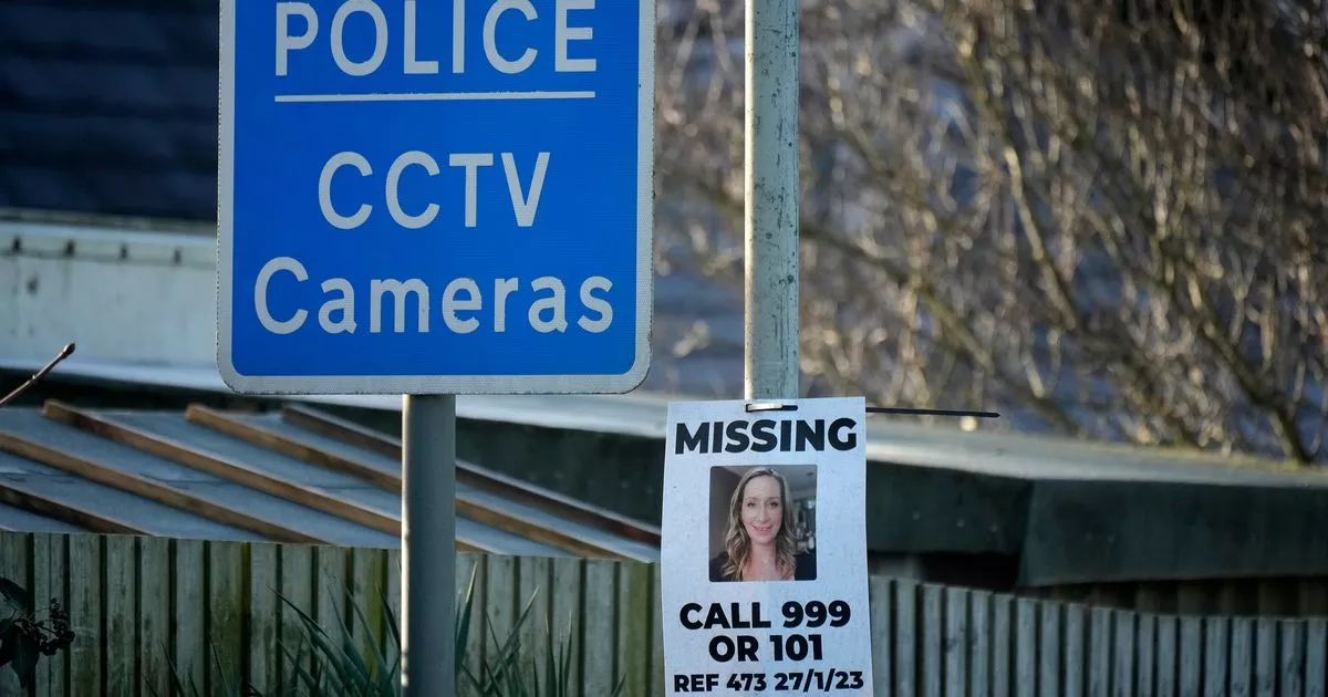
Found Deceased UK - Nicola Bulley Last Seen Walking Dog Near River - St Michaels on Wyre (Lancashire) #10

Status
Not open for further replies.
If somebody disappears next to a body of water, her belongings are found close by and her dog is in a distressed state near the water, it is not a ‘wild hypothesis’ that she went into the water. It is a reasonable assumption based on the known facts. And it still makes far more sense than any other theory out there, many of which are so implausible they border on lunacy.

Your comment that the police have ‘wasted days and days’ on the assumption that Nicola went into the water implies they haven’t considered any other explanation, which is a massive assumption on your part. Obviously they will be actively looking at other lines of enquiry too, but that doesn’t change the fact that the most likely explanation is still that Nicola went into the water

IMO without evidence she went in the water the likelihood is just 50/50. People go missing in mysterious circumstances not next to water and accidental drowning cannot be ruled in becuase there isn't water. If there was water, those serious murder/abduction enquiries would probably never happen. Certainly not initially. This would make abduction/murder next to water in isolated places the perfect crime.

Look at the case of Lindsay Birbeck, if she'd gone for a walk along a riverbank it would have been handled completely differently.
 
For some of the people who are criticising the police, please consider this:

When a person goes missing, the senior investigating officer (SIO) can't just sit on their hands and say that they're not going to devote any resources to here or there because there is not enough evidence to do so.

What they do is to evaluate the known facts of the case thus far and then make a judgement call to where to start the search, in the absence of any other evidence.

So, if a peson goes missing near a forest - the forest will be searched. If a person goes missing beside a lake, the lake will be searched. If a person goes missing on a building site, the site will be torn apart, and so on.

So, please, think about those facts before alleging that the police are engaging in wild speculation or unfounded hypothesis - they are devoting their resources to where they think they are best used. They have no other choice, and it's standard and proven procedure.

However, at the same time, they are also keeping an open mind to any other evidence that may be found. They have have a team of approaching fifty full time detectivges working behind the scenes to explore all known and potential lines of enquiry.
 
Last edited:
How an item behaves on water depends on density not weight.
A mannequin would float, just like a log would float. A human body would float too if it were alive, it’s the inhalation of water that makes it sink.
 
On a different note, I did a bit of sleuthing the other night, and I noticed something odd on Google Maps.

There is a property about a mile north of the riverside walk where NB went missing which has some odd features:

1. It has an elaborate suspended footbridge over the river, closed off to the public.
2. A large plot of land with very tall gates and "private property" keep out signs
3. It shares a very well built and neat retaining wall with parts of the Rowanwater development
4. The plot of land has access to a track that runs besides the river. This track pretty much runs all the way down to the point where NB was last seen.

Things I find odd about this:

a) It's a very elaborate bridge for it to be a private bridge. If it's there for a simple purpose, why is it so elaborate? It suggests it wasn't always private and possible once upon a time part of a public path. It's now gated off (see pictures) to prevent people accessing what is private land. It's not a bridge for vehicles, so it would never have been for farming or anything like that. There's a footpath on the other side of the river - so my hunch is that originally this bridge was put in place to serve as a crossing point for people walking beside the river - at some point the land has been bought and the footpath closed off.

b) It's a large plot of land, and the shared retaining wall with Rowanwater suggests there is some kind of link between the owners of the house/land and the owners of Rowanwater. Are they the same people? Was the land that Rowanwater is built on previously owned by the people who own the house?

c) The track/pathway appears to be private solely because there don't appear to be any public access points to it - but it would surprise me if you couldn't access this path from the 'upper field' near where NB was last seen. The path/track appears to be well trodden from satellite imagery both both foot and vehicles. The only vehicular access to the track is from the property mentioned above. At a certain point, the track appears to turn in to a slipway in to the river (highlighted in blue). Look at the track/path - they are clearly regularly used by vehicles.

View attachment 401839

View attachment 401840
View attachment 401844
Do you have a google link, so we can see the date these images were taken please?
 
On a different note, I did a bit of sleuthing the other night, and I noticed something odd on Google Maps.

There is a property about a mile north of the riverside walk where NB went missing which has some odd features:

1. It has an elaborate suspended footbridge over the river, closed off to the public.
2. A large plot of land with very tall gates and "private property" keep out signs
3. It shares a very well built and neat retaining wall with parts of the Rowanwater development
4. The plot of land has access to a track that runs besides the river. This track pretty much runs all the way down to the point where NB was last seen.

Things I find odd about this:

a) It's a very elaborate bridge for it to be a private bridge. If it's there for a simple purpose, why is it so elaborate? It suggests it wasn't always private and possible once upon a time part of a public path. It's now gated off (see pictures) to prevent people accessing what is private land. It's not a bridge for vehicles, so it would never have been for farming or anything like that. There's a footpath on the other side of the river - so my hunch is that originally this bridge was put in place to serve as a crossing point for people walking beside the river - at some point the land has been bought and the footpath closed off.

b) It's a large plot of land, and the shared retaining wall with Rowanwater suggests there is some kind of link between the owners of the house/land and the owners of Rowanwater. Are they the same people? Was the land that Rowanwater is built on previously owned by the people who own the house?

c) The track/pathway appears to be private solely because there don't appear to be any public access points to it - but it would surprise me if you couldn't access this path from the 'upper field' near where NB was last seen. The path/track appears to be well trodden from satellite imagery both both foot and vehicles. The only vehicular access to the track is from the property mentioned above. At a certain point, the track appears to turn in to a slipway in to the river (highlighted in blue). Look at the track/path - they are clearly regularly used by vehicles.

View attachment 401839

View attachment 401840
View attachment 401844
Possibly a bridge for "authorized personnel" to gain access to the other side in all weathers and flood conditions to access the flood alleviation equipment which can be seen as a concrete construction a little way downstream on the opposite bank.
So yes a public funded bridge but only for private acesss
 
I think something like this would be useful. Maybe not a mannequin, but a tracking package dropped in the river on day 1. Its movement can then be analysed after a few hours, 1 day etc to see how far and fast it moves in the current conditions, just to give an idea of how far something could travel in those first few hours and days. Maybe they can do already do this.
It would need to be a weighted mannequin, otherwise any other object would react differently. I disagree with infinit on many fronts, although he goes on to say more then one reconstruction could garnish results. With the search efforts in the river over the last 13 days has found nothing, we've learnt nothing.
 
A Tripadvisor image from summer 2019 shows the location of a camera at the Wyreside Farm camping location. It appears to look towards the land inside the farm, but not outside on the path or behind the farmhouse.

I have also uploaded an older image of the farm (brown paintwork) to show the exact location of the camera in relation to the surroundings. The green paintwork is more recent but you can tell from the white markings on the bricks of both images it is the exact same place.

Do we know if this is one of the cameras being discussed in the case and is it still up?

EDIT: Is that a second camera I spot on the left side of the green paintwork image pointing behind the farmhouse? Difficult to say...

Not sure if it’s included in this Daily Mail article and one would assume Lancashire police have been thorough as to collecting footage from those working.

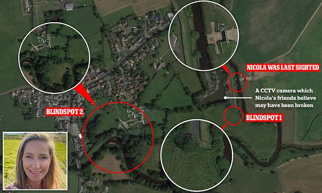
Meanwhile, three blind-spots have been identified in the area surrounding where Ms Bulley went missing - after police admitted she could have left the area via a path not covered by cameras.

The path in question leads to Garstang Road, which runs through the village, and is therefore a blind-spot.

Officers have been attempting to trace dashcam footage from 700 drivers who passed along the route at the time of her disappearance.

Aside from the river itself, there are only two other exits from the area, one of which is covered by CCTV.

 
How an item behaves on water depends on density not weight.
A mannequin would float, just like a log would float. A human body would float too if it were alive, it’s the inhalation of water that makes it sink.
Do you think that the police would have access to some sort of simulation software as well which would could map out the area of water and predict where an object could move or float depending on what parameters they input. IMO
 
Possibly a bridge for "authorized personnel" to gain access to the other side in all weathers and flood conditions to access the flood alleviation equipment which can be seen as a concrete construction a little way downstream on the opposite bank.
So yes a public funded bridge but only for private acesss
Certainly the only other explanation I can think of, but it doesn't quite stack up. It's a bit elaborate for it to be just for personnel to reach the flood-weir.

It's not a bridge for getting equipment across, or livestock, it's a footbridge. At some point it was public, I think.

Also, if you look closely at the street view image, you can see that there appears to be a faded sign with a walking-man with a cross through it - the kind of sign to see where land owners want to indicate no public right of way. It's just beneath the private property sign.
 
I think LE know what happened and are just waiting for more evidence. They put out things like the red van just to throw people off the scent and keep the story in the public eye. They must have hours of footage of the road from dash cams and cctv so could just find the van themselves quite easily.
 
I think LE know what happened and are just waiting for more evidence. They put out things like the red van just to throw people off the scent and keep the story in the public eye. They must have hours of footage of the road from dash cams and cctv so could just find the van themselves quite easily.
They didn't put that info. out there. The person who saw the van did.
 
Have a look at the link i have provided there is a picture if you scroll down to the lower part of the page which shows the CCTV in question. IMO

Nicola Bulley cops probe mystery 2-hour gap between disappearance and first call

Yes, that is the CCTV in the back field that isn't working.

My question is about the CCTV cameras on the Wyreside Cottage pictured in summer 2019. Do we know for sure *both* cameras are still up and these are definitely the cameras police have footage for?

Let's look at this hypothetically. I am not making any accusations but just trying to cover all areas. Say something happened outside my house, the police were involved and I didn't want them to see my footage for whatever reason, I could remove a camera with key details and they might not know I ever had it. To find me out we'd rely on previous Google footage/ photos or eyewitness accounts. In rural places it's less likely other locals are going to know exactly where cameras are and how many.
 
A Tripadvisor image from summer 2019 shows the location of a camera at the Wyreside Farm camping location. It appears to look towards the land inside the farm, but not outside on the path or behind the farmhouse.

I have also uploaded an older image of the farm (brown paintwork) to show the exact location of the camera in relation to the surroundings. The green paintwork is more recent but you can tell from the white markings on the bricks of both images it is the exact same place.

Do we know if this is one of the cameras being discussed in the case and is it still up?

EDIT: Is that a second camera I spot on the left side of the green paintwork image pointing behind the farmhouse? Difficult to say...

I don't know but I noticed this ref to Wyreside cameras in the Mail, if it's any use to you

'Another blind-spot is a riverside path leading from the Wyreside Farm Caravan Park through to the A586, or Garstang Road. A camera at a house close to the path is also understood to have not been working at the time, but did not cover the exit regardless.'

I am guessing that the 700 vehicles search ( for dash cam) might pick up any sightings leaving this area to the road, just because I'm guessing that's the 'way out' for a perpetrator. ( Obviously, if this is a criminal case but a local is involved, that's a different story, they might not need to get out onto the A586)

Any help from a local - much appreciated

Nicola Bulley's missing two hours: Detectives probe mystery gap
 
I wouldn't say it's an assumption.

The family clearly believe that is the case, so does the expert diver.

This person went missing further upstream than Nicola on exactly the same date 45 years before. They were found 2 months later near the estuary (I take no credit for finding the article, another member did.)


I'd love to get Peter Faulding's views.
 
Status
Not open for further replies.

Staff online

Members online

Online statistics

Members online
211
Guests online
3,568
Total visitors
3,779

Forum statistics

Threads
592,252
Messages
17,966,058
Members
228,733
Latest member
jbks
Back
Top