
You are using an out of date browser. It may not display this or other websites correctly.
You should upgrade or use an alternative browser.
You should upgrade or use an alternative browser.
TX TX - Brandon Lawson, 26, San Angelo, 8 Aug 2013 - #3
- Thread starter BlithePlum
- Start date
New Posts
-
Abby & Libby - The Delphi Murders - Richard Allen Arrested - #181
- Latest: steeltowngirl
-
 OJ Simpson dead at 76, after short battle with prostate cancer
- Latest: ChatteringBirds
- Status
- Not open for further replies.
Bigmomma29
New Member
- Joined
- Mar 7, 2014
- Messages
- 192
- Reaction score
- 1
So... not much to discuss that's within TOS. We can talk about our opinions as long as we make it clear it's just our opinion with IMO (in my opinion) or the beloved MOO cow(my opinion only).
MOO :moo:
I'm about 50/50 now for deceased vs on the run.
What's everyone thoughts?
I still stand firm on my thoughts. I still hope and pray for closure soon for Brandon's children and family.
I still believe that who ever last seen him on August 9, 2013 and tell the truth.
Here is a question, do y'all think raising the reward for information, will really help in this case?
Bigmomma29
New Member
- Joined
- Mar 7, 2014
- Messages
- 192
- Reaction score
- 1
Oh just my opinion^^^^^^^
Stella888
On a Mission
- Joined
- Jan 2, 2014
- Messages
- 299
- Reaction score
- 150
I still stand firm on my thoughts. I still hope and pray for closure soon for Brandon's children and family.
I still believe that who ever last seen him on August 9, 2013 and tell the truth.
Here is a question, do y'all think raising the reward for information, will really help in this case?
I'm not sure. The only people who know what happened that night wouldn't benefit from the "reward for information" without implicating themselves.
Just my opinion of course. :jail:
Psychic Sleuth
Well-Known Member
- Joined
- Dec 7, 2011
- Messages
- 5,698
- Reaction score
- 4,949
I still stand firm on my thoughts. I still hope and pray for closure soon for Brandon's children and family.
I still believe that who ever last seen him on August 9, 2013 and tell the truth.
Here is a question, do y'all think raising the reward for information, will really help in this case?
I think it could help if he's alive, but it all depends how the reward is worded. Sometimes they can be tricky.
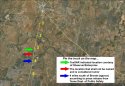
That map was from the TexSAR briefing report. It is correct.
That's interesting. So, according to that location Brandon's truck was across the road from a lighted gate area.
My concern is that supposedly official press releases and mainstream media reports have contained some rather far ranging locations for the truck. MSM just a few weeks ago said the truck was 4 miles north of Bronte and another referred to it as being "between Bronte and Abilene."
In the scope of things the exact, precise, down to the inch location isn't all that relevant in the search. It's just another of the "facts" of this case that seems to be a variable. So here's yet another map showing the reported locations south of Bronte. The yellow numbers are showing # of miles south of Bronte.
Attachments
Psychic Sleuth
Well-Known Member
- Joined
- Dec 7, 2011
- Messages
- 5,698
- Reaction score
- 4,949
That's interesting. So, according to that location Brandon's truck was across the road from a lighted gate area.
My concern is that supposedly official press releases and mainstream media reports have contained some rather far ranging locations for the truck. MSM just a few weeks ago said the truck was 4 miles north of Bronte and another referred to it as being "between Bronte and Abilene."
In the scope of things the exact, precise, down to the inch location isn't all that relevant in the search. It's just another of the "facts" of this case that seems to be a variable. So here's yet another map showing the reported locations south of Bronte. The yellow numbers are showing # of miles south of Bronte.
I'm going to assume TexSAR got their info from LE and that would seem the most accurate. It's so hard to get accurate info! :banghead:
Psychic Sleuth
Well-Known Member
- Joined
- Dec 7, 2011
- Messages
- 5,698
- Reaction score
- 4,949
Has the new ping info been in the MSM? I don't even know if we can discuss that now??
It was mentioned in the blog talk interview posted in the media thread.Has the new ping info been in the MSM? I don't even know if we can discuss that now??
There was also a press release March 3 which gave more details, but I don't see where the release was run by MSM.H: <snip> Let's go on with the timeline for a little bit. On that call at 1:19 where he was bleeding and he was out, the phone call was coming in and out and he was out in this field somewhere. Last night you said there was a ping that was about 4 miles away from where the vehicle was.
LL: Yeah, it was about 4 1/4 of a mile. It was pings at the Colorado River, but my private investigator, her name is BP, and she is awesome. She is just, God couldn't have gave me a better PI, a caring PI that's just been here for me and my family and my children, and she's cried with me during this, and it's hard to find people like that, but she cares about people. And she was able to do research and we absolutely got what the Rangers were working on, but we got a better ping of Brandon's area because the last ping was two to three miles off and B was able to pull some strings and do different things and was able to find out that we could get a closer ping. And we thought the records was not with us no more. The records, because so long, they don't keep up with the pings if it's been so long. But I'm looking forward to knowing that and maybe we will have a bit more indication of where Brandon is, because I don't think it'll be a lot of fee. I'm not sure.
H: All right. And was that area down there by the Colorado River where they had indication where he was, was that area searched at all?
LL: Yeah. Let's see, when this first happened, the Texas Rangers and WM, they did a helicopter search around all that area on that Tuesday. Also, they waited 21 days and did another search, and they didn't find anything around the truck. And then TEXSAR came in about, I'm trying to think when they came in. I want to say they came in in October. Yeah, October they came in sometime, TEXSAR did with some cadaver dogs and they searched that area and they searched around the truck. I'm not for sure, it's on the Help Find Brandon Lawson page, how far that they searched but they said that they did have them around the area that Brandon pinged. But that ping, they say it would have been off two or three miles at the most. But the other ping would be more accurate than this, because this one's not very accurate. Because I don't think Brandon could have made in the rough terrain out there 4 1/4 of a mile because when you're out there it's dark. It's pitch black. It's rough out there.
Ranch Wife
Verified insider - Brandon Lawson case
- Joined
- Mar 14, 2014
- Messages
- 44
- Reaction score
- 2
The press release was issued by DPS (Ranger) and was run in SanAngeloLive.com. That is an online newspaper serving San Angelo and the area surrounding it.
Psychic Sleuth
Well-Known Member
- Joined
- Dec 7, 2011
- Messages
- 5,698
- Reaction score
- 4,949
MM, do you know why the majority of the searches were focused to the south, east and west of the truck? And in techpuppy's map below the green outlines the search area and I know TexSAR extended their search to the NE close to the river. Would that be near the NE point in green on this map that is real close to the river?
http://www.websleuths.com/forums/attachment.php?attachmentid=41529&d=1393993812
http://www.websleuths.com/forums/attachment.php?attachmentid=41529&d=1393993812
Psychic Sleuth
Well-Known Member
- Joined
- Dec 7, 2011
- Messages
- 5,698
- Reaction score
- 4,949
Also, looking at the map above-the outer blue ring shows 3 miles out from the truck location which would indicate how far away the new ping location is. Is it really possible that he could have gotten that far by the ping time of 1:18 am? I just don't see how that is possible given the timeline. Even if he started walking immediately after calling K for the gas cans at 12:38 am, how would it be possible to walk that far in rough terrain in 40 minutes?
Stella888
On a Mission
- Joined
- Jan 2, 2014
- Messages
- 299
- Reaction score
- 150
Also, looking at the map above-the outer blue ring shows 3 miles out from the truck location which would indicate how far away the new ping location is. Is it really possible that he could have gotten that far by the ping time of 1:18 am? I just don't see how that is possible given the timeline. Even if he started walking immediately after calling K for the gas cans at 12:38 am, how would it be humanly possible to walk that far in rough terrain in 40 minutes?
In describing "rough terrain" do you mean like rocky terrain or in heavy brush like? I keep thinking that for the most part it's very open terrain with dry brush. Like tumbleweed terrain. I've been to Odessa/Midland before and if I recall, I remember it being almost desert like with small trees here and there and VERY hot, even at night. Even if you are running at night in the August heat it would take a toll on a body. Especially someone with a stocky build. I just don't see this being possible to get that far on foot.
IMO
Psychic Sleuth
Well-Known Member
- Joined
- Dec 7, 2011
- Messages
- 5,698
- Reaction score
- 4,949
In describing "rough terrain" do you mean like rocky terrain or in heavy brush like? I keep thinking that for the most part it's very open terrain with dry brush. Like tumbleweed terrain. I've been to Odessa/Midland before and if I recall, I remember it being almost desert like with small trees here and there and VERY hot, even at night. Even if you are running at night in the August heat it would take a toll on a body. Especially someone with a stocky build. I just don't see this being possible to get that far on foot.
IMO
I think MM explained the terrain. Maybe she'll come back and explain it again? She would know better than anyone. If you look at maps there are definitely trees and shrubbery. I've seen cactus mentioned but I'm not sure on that and all the properties I saw have barbed wire fencing and lots of wild hogs and rattlenakes makes for rough terrain also. Someone also mentioned old wells and such. It's not just flat open land with a few tumbleweeds here and there. There are some area's with more trees than others like to the south of the truck location.
Stella888
On a Mission
- Joined
- Jan 2, 2014
- Messages
- 299
- Reaction score
- 150
That's interesting. So, according to that location Brandon's truck was across the road from a lighted gate area.
My concern is that supposedly official press releases and mainstream media reports have contained some rather far ranging locations for the truck. MSM just a few weeks ago said the truck was 4 miles north of Bronte and another referred to it as being "between Bronte and Abilene."
In the scope of things the exact, precise, down to the inch location isn't all that relevant in the search. It's just another of the "facts" of this case that seems to be a variable. So here's yet another map showing the reported locations south of Bronte. The yellow numbers are showing # of miles south of Bronte.
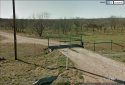
I have a question about the truck being found by a lighted gate. Can this lighted gate be seen on Google maps or has it been mentioned before? Just curious?
No, I'm not saying the truck was found by a lighted gate. Looking at google images there is a lighted gate across the highway from where the truck was found if we go by the location attributed to TexSAR. It would seem to me a lighted anything would be a natural spot for a reference if you wanted to be found.I have a question about the truck being found by a lighted gate. Can this lighted gate be seen on Google maps or has it been mentioned before? Just curious?
In the attached photo you can see the lights on top of the gate posts. There is an electrically operated gate mechanism there as well. Nearby is what may be a well house.
The image is from February 2013.
Attachments
Psychic Sleuth
Well-Known Member
- Joined
- Dec 7, 2011
- Messages
- 5,698
- Reaction score
- 4,949
No, I'm not saying the truck was found by a lighted gate. Looking at google images there is a lighted gate across the highway from where the truck was found if we go by the location attributed to TexSAR. It would seem to me a lighted anything would be a natural spot for a reference if you wanted to be found.
In the attached photo you can see the lights on top of the gate posts. There is an electrically operated gate mechanism there as well. Nearby is what may be a well house.
The image is from February 2013.
This photo also gives an idea of the terrain up near the truck location. It's a little more wooded south by the rest area and lots of barbed wire fencing and we have to remember that there was little to no moon that night so it would be pretty dark out there. I remember seeing the temps that day and night and it was quite warm also. Do rattlesnakes come out at night in the heat? LL mentioned lots of rattlesnake bites in that area.
Still I wonder how far he could have gotten in 40 mins or so, in pitch black darkness, given the terrain, snake/wild hog dangers and his condition? It just doesn't seem rational to me that he could get that far by the time of the 1:18 ping on foot. If we had an idea of which direction that ping was it would be nice so we could have a look at the terrain in that specific area.
We know that he supposedly told K and A he was 10 minutes up the road but I'm not sure at what point he said that. There was said to be intermittent communication (that kept losing signal) during the time K and A were driving out there and while they and the Deputy were at the truck. We know B was alive then (1:10) and at 12:53 when he called 911. I don't think there was ever a response to the 1:18 text sent from A to B saying the cops were at his truck.
My thinking has completely changed from the beginning when I learned about B and after listening to the 911 call. Then I was most certain some bad guys had gotten him. Now I'm leaning towards being bitten by a snake or attacked by a hog, an OD or he's on the run. If there truly are old wells out there that aren't covered he could have fell in a well or something too.
Looking at the picture of the gate, I would say that picture was taken in a different season than in summer. The trees you see are probably mesquite, which have very small thin leaves on them in August. They also have very rough bark and some really evil thorns. If you will look close there are little ones in between the big ones also. Very easy to trip over in the dark. These trees can get very thick, in other words lots of them in small area. I would have to agree, in my opinion it would be almost impossible if traveling through the pasture (field as he referred to it) at night to make it very far in that time frame.
- Status
- Not open for further replies.
DNASolves
Online statistics
- Members online
- 188
- Guests online
- 1,460
- Total visitors
- 1,648
Totals may include hidden visitors.