CA CA - Barbara Thomas, 69, from Bullhead City AZ, disappeared in Mojave desert, 12 July 2019 #7

Status
Not open for further replies.

fictionisbetter

Active Member
Joined
Dec 4, 2017
Messages
99
Reaction score
216
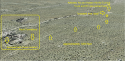
Barbara Thomas was hiking with her husband in the Mojave Desert and they became separated. She has not been seen since.

Search underway for lost hiker in Mojave Desert

"Thomas does not have supplies or a cell phone, and she was last seen wearing a black bikini, red baseball cap and tan hiking boots with black socks."

"She is a resident of Bullhead City, and she is 5 feet and 9 inches tall, weighing about 130 pounds, with blonde hair and green eyes."

Thread #1
Thread #2
Thread #3
Thread #4

Thread #5 - CA - CA - Barbara Thomas, 69, from Bullhead City AZ, disappeared in Mojave desert, 12 July 2019 #5
Thread #6 - CA - CA - Barbara Thomas, 69, from Bullhead City AZ, disappeared in Mojave desert, 12 July 2019 #6
 
Last edited by a moderator:
Size of Original SAR Search Area? Modified?
....darn difficult to find people outdoors. I vote for another search extended beyond the 1/4 mile radius....
@rosesfromangels :) thanks for your post, prompting me to wonder again.
dbdb11 or anyone.

How large was SAR's originally designated search area ---
- 1/4 mi x 1/2 mi or 1/3 mi +/- diameter circle ( yes, i know not geometric shapes)?
- 1/2 mi x 1 mi?
- 1 mi x 2 mi?
As days of no-evd-found passed, did SAR significantly enlarge the search area?
Then what size?


If this was released by SAR/LE, I missed it. Thx in adv.
 
Topographic Map?
We've been discussing the walking/hiking trail terrain: some say flat, some say hilly, a wide discrepancy. Lots of ppl here are smarter & more experienced than me about topo maps.

Surely someone can post a screenshot of or a link to a topo map and show/tell us the scale, contour lines interval, mark the trail on the map, if not already designated, etc. and what the elevation gain and drop is over this (supposed) two mile trail.
I think this would give us a different feel for the terrain than what we discern from overhead/birdseye views/maps. IOW help us interp what we are seeing on topo and how it relates to RT & BT's situation. Thx in in adv.


Wow. Were they found in the same area? They just missed the woman the first time they searched there?
People are very hard to find outside even when the terrain is flat and there is little to no cover. I don't understand, it but I have seen enough cases on this board of people being found 2000-3000 feet from where they were last spotted! ...sometimes days or weeks later after "exhaustive" searches. These people were a bit farther than that but they had hiked on a lava field! Flat, mostly featureless and almost no cover what-so-ever.

She absolutely could be lost there, she absolutely could be right where the searchers already looked.

Missing hiker's remains found after 'thousands of hours searching'
 
Nah.
She ain't there.
If she were, they would have found some sign of her somewhere.
A bootprint. Her hat. Something.
They're going to need to look elsewhere for her.
Possibly a different location in that desert.

JMO.

There was a young man who went missing in Turkey, in a simular area and weather conditions.
They searched for him for weeks, found no trace, no item, nothing.
Everybody felt his travel mates had harmed him.
Then 7 weeks later, another search group found him around 300m from the place where he was last seen, he had been there the entire time.

From this story (many links if you want) you can conclude that it is absolutely untrue that "they must have found something" and IMO unjust to conclude "she ain't there".

Let me know if you want some links about the young man who went missing in Turkey (I have posted them a few times in the previous threads), I will then look them up for you.
All IMO
 
Last edited:
I am NOT tech savvy, so bear with me on my very un-techy language, lol:

I don’t know if this is also visible through Google Maps, but I was on Google Earth at these coordinates: (34.8036730, -115.6118710)
There is what appears to be a large dirt turnout on the west side of Kelbaker, but if I do the following I see an actual paved parking lot:

I touched the little stick-type of person of Google Earth, which I guess gives you a look on the street. Kelbaker turns blue, but there’s also little blue dots nearby where apparently people submitted their own photos. I touched a couple of those dots near the lot, and lo and behold I see an asphalt lot striped for cars to park.

Could this be the one visible on the 360 photo?
Good find. It doesn't show up on the Streetview images, but they are very old (2008) and quite poor quality. But neither does it show up on the satellite view, which I'd have expected it to. I wonder if the photographer has marked the right spot.
Here's the link to the photo, which is dated Oct 2018 so less than a year ago.
Google Maps
 
I'm surprised to see vehicle tracks so clearly in the Google images linked above. I know RT was upset that officials drove on top of any existing tracks, but I don't recall if he mentions noticing anything out of the ordinary. It seems one would be able to see any new tire tracks, footprints, sign of a struggle, etc.
JMO, MOO, etc
 
Topographic Map?
We've been discussing the walking/hiking trail terrain: some say flat, some say hilly, a wide discrepancy. Lots of ppl here are smarter & more experienced than me about topo maps.

Surely someone can post a screenshot of or a link to a topo map and show/tell us the scale, contour lines interval, mark the trail on the map, if not already designated, etc. and what the elevation gain and drop is over this (supposed) two mile trail.
I think this would give us a different feel for the terrain than what we discern from overhead/birdseye views/maps. IOW help us interp what we are seeing on topo and how it relates to RT & BT's situation. Thx in in adv.

heres the link to streetview Google Maps

From looking at the video at the search I would say that the road is higher than its immediate vacinity. Looking at this terrain, IMO, I dont think it would be easy to find someone. I will look and see if I cn find a topo map for you.
 
Topographic Map?
We've been discussing the walking/hiking trail terrain: some say flat, some say hilly, a wide discrepancy. Lots of ppl here are smarter & more experienced than me about topo maps.

Surely someone can post a screenshot of or a link to a topo map and show/tell us the scale, contour lines interval, mark the trail on the map, if not already designated, etc. and what the elevation gain and drop is over this (supposed) two mile trail.
I think this would give us a different feel for the terrain than what we discern from overhead/birdseye views/maps. IOW help us interp what we are seeing on topo and how it relates to RT & BT's situation. Thx in in adv.

From the media thread, post #1

https://www.nps.gov/moja/planyourvisit/upload/MOJAmap1.pdf

AZ - AZ - Barbara Thomas, 69, Timeline, Media, Maps, *NO DISCUSSION*
 
Micheline, can you please give us the link? Thanks.

Eta: having difficulty quoting
There was a young man who went missing in Turkey, in a simular area and weather conditions.
They searched for him for weeks, found no trace, no item, nothing.
Everybody felt his travel mates had harmed him.
Then 7 weeks later, another search group found him around 300m from the place where he was last seen, he had been there the entire time.

From this story (many links if you want) you can conclude that it is absolutely untrue that "they must have found something" and IMO unjust to conclude "she ain't there".

Let me know if you want some links about the young man who went missing in Turkey (I have posted them a few times in the previous threads), I will then look them up for you.
All IMO

Making sure this gets seen. Plus, I've never multi quoted. ;)
 
@PommyMommy - cannot locate your media thread, so unsure whether this article is included?
Cops dismiss husband's claim that his bikini-clad wife who went missing during their hike was abducted

In regards to the abduction theory - this article shows that the this came from the Powell case on the same day:

While Robert believes that Barbara had been abducted, the police have refuted that theory. "We don't think she was abducted. It's a very remote area. There's no evidence to suggest she was abducted," San Bernardino County Sheriff's Department spokeswoman Jodi Miller told Daily Mail. Miller also said that the kidnapping theories had risen from another case about 300 miles away, where a woman was rescued after several days. She had said that she ran after being chased by a man with a knife.

"When that information started coming out about [the other woman], that's what created the speculation [that Barbara had been abducted]. But our investigation does not indicate any signs that she was abducted," Miller said.
 
@Nikynoo

The media thread is here:
AZ - AZ - Barbara Thomas, 69, Timeline, Media, Maps, *NO DISCUSSION*

The original story by The Daily Mail is here:
AZ - AZ - Barbara Thomas, 69, Timeline, Media, Maps, *NO DISCUSSION*

California police say missing hiker who vanished 'in her bikini' was NOT abducted | Daily Mail Online
[...]

'We don't think she was abducted. It's a very remote area. There's no evidence to suggest she was abducted,' spokeswoman Jodi Miller told DailyMail.com.

The notion that Barbara may have been abducted became public after a different hiker, Shirley Powell, who was missing for days in a different national park 300 miles away, was rescued. After being found, she described being chased by a knife-wielding man.

But sheriffs say it is unlikely the same man she described has gone after Barbara.

'When that information started coming out about [the other woman], that's what created the speculation [that Barbara had been abducted] but our investigation does not indicate any signs that she was abducted,' Miller said.

[...]

(I have asked for the link to the media thread to be included on page 1, post 1 of the thread but I'll ask again. I don't think meow or whatever that is, is an approved MSM source. I don't consider it one, but RadarOnline is allowed here, so you never know.)
 
"When that information started coming out about [the other woman], that's what created the speculation [that Barbara had been abducted]."

Of course! That seems so obvious now. I feel quite stupid for not realising that.
I still think the mention of Las Vegas was probably prompted by a suggestion from the journalist who interviewed RT, and RT agreed in a "anything's possible" kind of response.
 
Good find. It doesn't show up on the Streetview images, but they are very old (2008) and quite poor quality. But neither does it show up on the satellite view, which I'd have expected it to. I wonder if the photographer has marked the right spot.
Here's the link to the photo, which is dated Oct 2018 so less than a year ago.
Google Maps

I believe the parking lot is the Providence Mountains State Recreation Area. If you look it up on Google, and look at the photos around there, or just zoom in,you'll see images of the square parking lot (sorry my tech skills are not good enough to post the photos I found, maybe someone else can). Now, where would you need to be, to get a photo that would have that parking lot in it? Not sure. Might validate the theory that the 360 degree photo was taken earlier in the day from another location? Could they have gotten high enough, in a 1 mile walk, to view that side of the mountain from where RT says they were parked? And if a car was parked at that parking lot, how long would it take to get from there to where the RV was? If the photo you are refering to was taken from near where the RV was parked, as it is linked there, maybe it would be possible to see...
 
Topographic Map?
We've been discussing the walking/hiking trail terrain: some say flat, some say hilly, a wide discrepancy. Lots of ppl here are smarter & more experienced than me about topo maps.

Surely someone can post a screenshot of or a link to a topo map and show/tell us the scale, contour lines interval, mark the trail on the map, if not already designated, etc. and what the elevation gain and drop is over this (supposed) two mile trail.
I think this would give us a different feel for the terrain than what we discern from overhead/birdseye views/maps. IOW help us interp what we are seeing on topo and how it relates to RT & BT's situation. Thx in in adv.

This is a great image created by @ChuckMaureen depicting a birds eye view of the rock formations and the trail leading to where the RV was reportedly parked.
 

Attachments

  • BT missing.png
    BT missing.png
    1.3 MB · Views: 109
Below find links
-to website dedicated to find topographical maps,
-to topo map of area of interest
-screenshot of same

Tapping the buttons gives different options, including the ability to download a free US Topo map. Tapping US Topo divides the section into quadrants; then I selected the one including Granite Peak, and got this very detailed topography map

Link to specific topography map including Granite Peak:

https://prd-tnm.s3.amazonaws.com/St...o/PDF/CA/CA_Bighorn_Basin_20150223_TM_geo.pdf

Link to find and identify the topography map you want

Granite Peak Topo Map in San Bernardino County, California

Screenshot of 2nd link provided above:

upload_2019-8-19_7-48-45.png

ETA @al66pine (since he requested the topography map) and me repeating his request for other more tech savvy members to add points of interest
 
Last edited:
Status
Not open for further replies.

Members online

Online statistics

Members online
128
Guests online
3,207
Total visitors
3,335

Forum statistics

Threads
592,294
Messages
17,966,770
Members
228,735
Latest member
dil2288
Back
Top