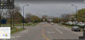
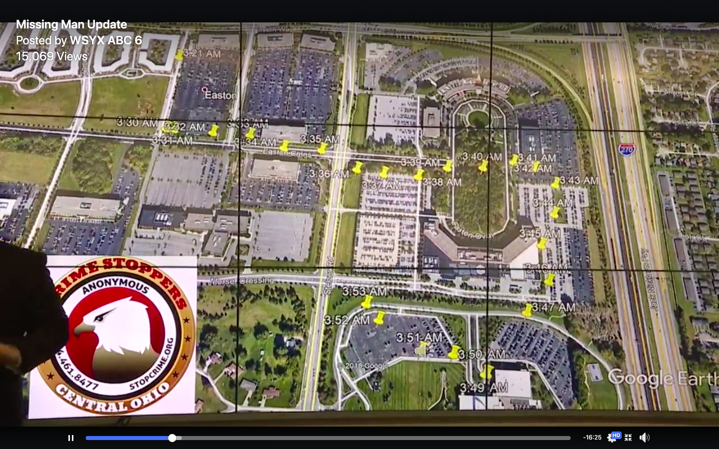
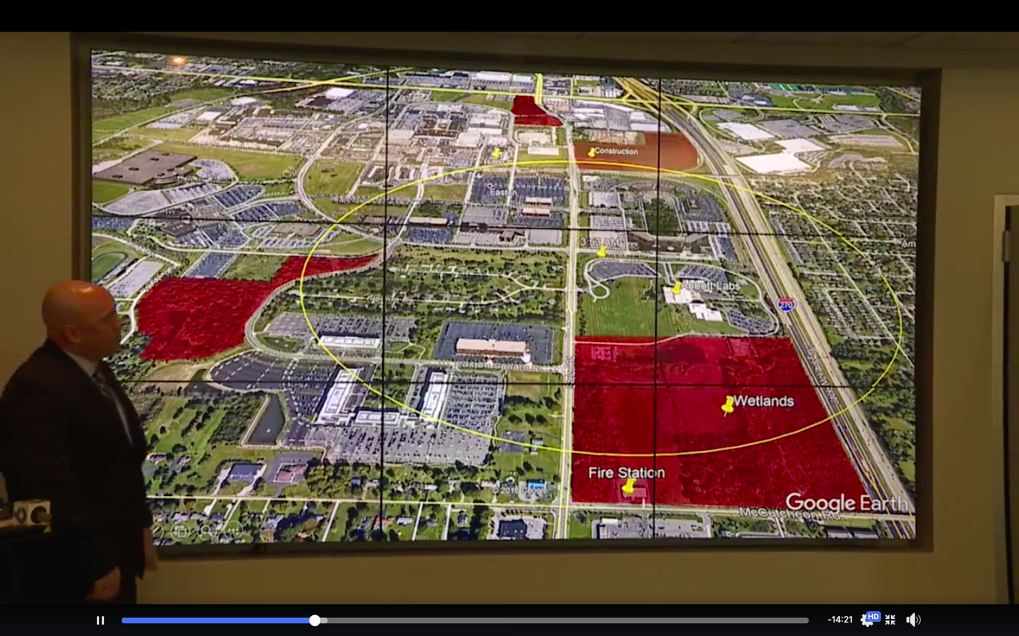
Here is the map from the press conference. The area I circled that is marked construction is the area I posted pics of a couple of posts ago. Right above that area is Costco. The smaller area up top is directly across from Morse Rd. Across the street from Morse higher up is a gas station and to the right is the Hampton Inn. I posted on another forum a while back that if Tyler came out of that wooded area from Stelzer onto Easton Loop E he could have mistaken Nordstom for the Hilton possibly because of the steeple they both have. In the dark he may have thought he was looking at the Hilton but was looking at Nordstrom. The other two pics are of the Hilton and Nordstrom. From where he could have been standing right out of that wooded area he would have had a view of both places at almost the same vantage point. To me they look kind of similar.

You are using an out of date browser. It may not display this or other websites correctly.
You should upgrade or use an alternative browser.
You should upgrade or use an alternative browser.
OH OH - Tyler Davis, 29, Columbus, 24 February 2019 #2
- Thread starter moonriverfarm
- Start date
New Posts
-
 IA IA - David Schultz, 53, Wall Lake, 21 November 2023 #3
- Latest: JerseyWasHome2
- Status
- Not open for further replies.


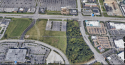
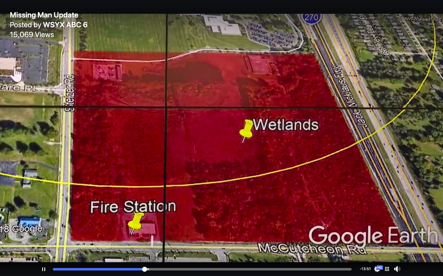
Here is a closer view of the smaller wooded area that was marked in red. Notice the walking path marked Easton loop N. If I am remembering correctly on the other side to the right on Stelzer the path is marked but I could be wrong. This could have made Tyler take a right through those woods.
Attachments
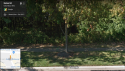
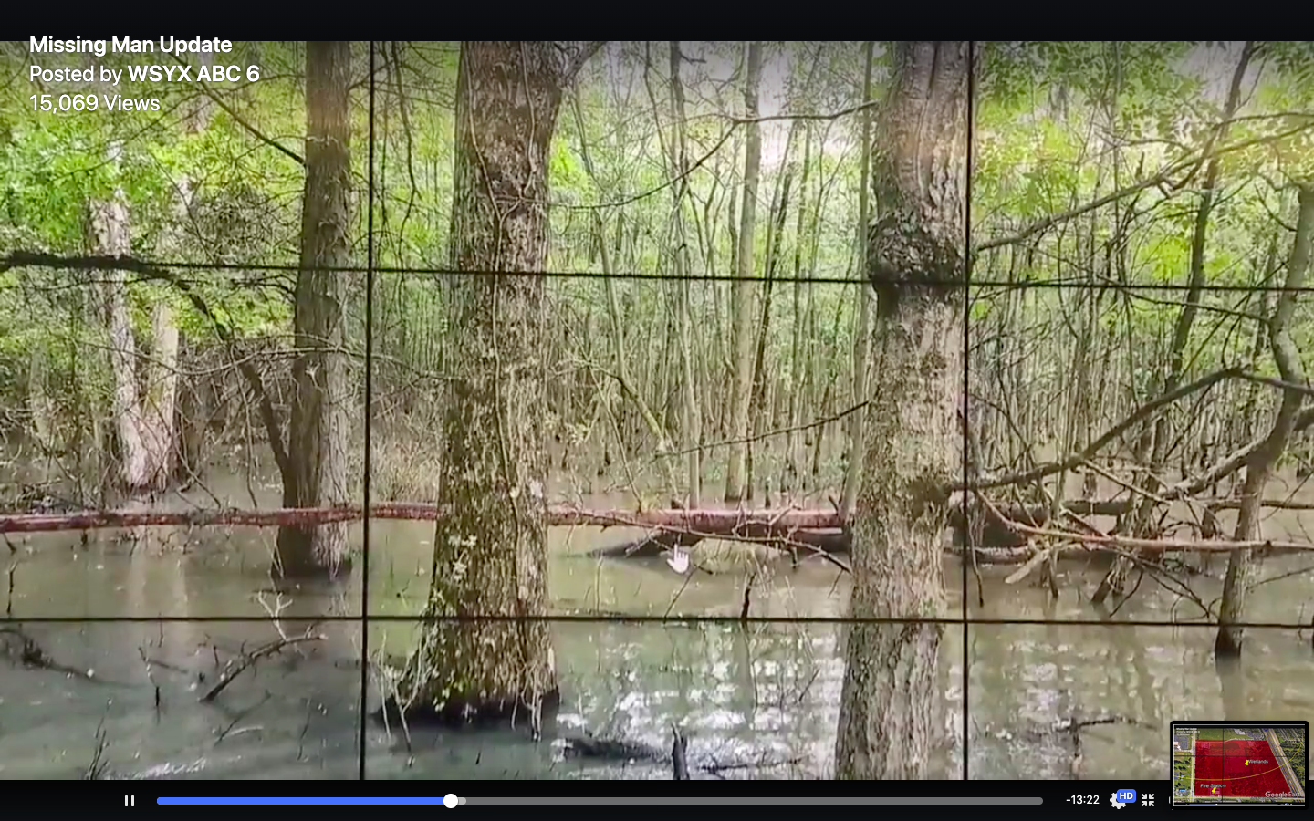
This is the view from Stelzer into the wooded are marked Easton Loop N. If you look at the bottom left of the tree you can see an arrow painted in green. That arrow is pointed exactly where they show the path that goes through the wooded area that says Eaton Loop N. That arrow could mean something else and I have no idea what that path might have looked like that night Tyler went missing.
Attachments
swedeheart
Well-Known Member
- Joined
- Jun 7, 2016
- Messages
- 3,114
- Reaction score
- 48,159
wow. i guess you don't hear about this happening too often, but it absolutely can happen. (this was in new york, found today).
posting since it's been mentioned as a possibility for what happened to tyler.
https://nypost.com/2019/10/15/decom...utm_campaign=SocialFlow&utm_medium=SocialFlow
posting since it's been mentioned as a possibility for what happened to tyler.
https://nypost.com/2019/10/15/decom...utm_campaign=SocialFlow&utm_medium=SocialFlow
DutchTreat
Well-Known Member
- Joined
- Jun 27, 2014
- Messages
- 1,534
- Reaction score
- 4,272
I don't think he was there, why would he go into pitch black 'woods' at that spot?This is the view from Stelzer into the wooded are marked Easton Loop N. If you look at the bottom left of the tree you can see an arrow painted in green. That arrow is pointed exactly where they show the path that goes through the wooded area that says Eaton Loop N. That arrow could mean something else and I have no idea what that path might have looked like that night Tyler went missing.
'The woods' at the Easton Oval where digital forensics puts him, have lanterns in it and a clear path.
Wouldn't he have said to Brittany ' I'm in the woods but I can't see where I'm going' or something like 'there is no path'?
DutchTreat
Well-Known Member
- Joined
- Jun 27, 2014
- Messages
- 1,534
- Reaction score
- 4,272
The building Tyler would have thought to have been the Hilton while walking through 'the woods' would probably have been the building between 'the woods' inside the Easton Oval and the Abbott parking lot.
I can imagine a disoriented intoxicated person thinking it was the Hilton seen through the trees.
I can imagine a disoriented intoxicated person thinking it was the Hilton seen through the trees.
I don't think he was there, why would he go into pitch black 'woods' at that spot?
'The woods' at the Easton Oval where digital forensics puts him, have lanterns in it and a clear path.
Wouldn't he have said to Brittany ' I'm in the woods but I can't see where I'm going' or something like 'there is no path'?
A walking map in Gmail is not digital forensics. Especially when you can alter your path to make it look like you have or have not been somewhere. I'm not trying to belittle your terminology. A phone ping I would say yes and GPS satellite I'd say yes, but if a walking map can be altered then it isn't proof. I'm not saying it's worthless info. In fact I personally think it's good because if it's legit then it shows where he was, if it's been altered then I would assume they know and are looking into why.
We where told during the presser that the areas in red have been searched or are being looked into as possible areas Tyler was either at or still could be. The walking path is in the direct area they marked off in red. So yes he could have walked into those woods. What confuses me (well not really) is how could Tyler be in the other areas if that walking map is legit. No one is going to dump his body by Costco or by the Hampton Inn. The best place to take him would be to Sunbury Rd. and coincidentally that is also an area marked in red. It would not be the first time someone dumped a body there.
DutchTreat
Well-Known Member
- Joined
- Jun 27, 2014
- Messages
- 1,534
- Reaction score
- 4,272
So how do you think the map they showed at the presser was made? They must have done something to be able to show us the route Tyler took according to them?A walking map in Gmail is not digital forensics. Especially when you can alter your path to make it look like you have or have not been somewhere. I'm not trying to belittle your terminology. A phone ping I would say yes and GPS satellite I'd say yes, but if a walking map can be altered then it isn't proof. I'm not saying it's worthless info. In fact I personally think it's good because if it's legit then it shows where he was, if it's been altered then I would assume they know and are looking into why.
We where told during the presser that the areas in red have been searched or are being looked into as possible areas Tyler was either at or still could be. The walking path is in the direct area they marked off in red. So yes he could have walked into those woods. What confuses me (well not really) is how could Tyler be in the other areas if that walking map is legit. No one is going to dump his body by Costco or by the Hampton Inn. The best place to take him would be to Sunbury Rd. and coincidentally that is also an area marked in red. It would not be the first time someone dumped a body there.
So how do you think the map they showed at the presser was made? They must have done something to be able to show us the route Tyler took according to them?
For anyone here who is not familiar with the info that Gmail stores from an Android cell phone, Gmail will save a lot of info. The walking map can be part of it and each time someone asks google for directions it will store the Long. Lat. coordinates for each time you ask. So basically once you speak the GPS is finding the exact spot you are standing in. This isn't me speculating or a theory, this is a fact. It can also record every place on the internet that you searched for. It will follow you by car and walking as we have seen with Tyler's phone. It will tell you if an app has been updated, it will tell you the last time the phone synced. So IMO based on all the places of interest and the places they searched I'm not 100% convinced that the walking map is solid.
The Night Watchman
Former Member
- Joined
- Oct 6, 2011
- Messages
- 1,193
- Reaction score
- 15,871
For anyone here who is not familiar with the info that Gmail stores from an Android cell phone, Gmail will save a lot of info. The walking map can be part of it and each time someone asks google for directions it will store the Long. Lat. coordinates for each time you ask. So basically once you speak the GPS is finding the exact spot you are standing in. This isn't me speculating or a theory, this is a fact. It can also record every place on the internet that you searched for. It will follow you by car and walking as we have seen with Tyler's phone. It will tell you if an app has been updated, it will tell you the last time the phone synced. So IMO based on all the places of interest and the places they searched I'm not 100% convinced that the walking map is solid.
In my opinion, they defined these search areas because there was little else to search. The Easton area is mostly open spaces, parking lots, buildings, houses etc, and a highway blocking the east side.
In my opinion, they defined these search areas because there was little else to search. The Easton area is mostly open spaces, parking lots, buildings, houses etc, and a highway blocking the east side.
I agree but only to a point. There a ton of wooded areas around that area so why go to the opposite end of that town when it seems that they know where he was at 3:53 am. Did somebody grab him at the far end of Abbott Labs parking lot at 3:53 am and drive him to the other end of town and dump him at Costco or over by Morse Rd? No, you grab him and drive on Stelzer drive the opposite way and take a right on McCutcheon Dr all the way to the Innus Park Alum Creek area which is right by Sunbury Rd. You don't drive into town with a body in your trunk. If he was grabbed at Abbott that's one scenario.
The building Tyler would have thought to have been the Hilton while walking through 'the woods' would probably have been the building between 'the woods' inside the Easton Oval and the Abbott parking lot.
I can imagine a disoriented intoxicated person thinking it was the Hilton seen through the trees.
I swear I am not picking on you. lol OK so Brittany had stated many time in interviews that Tyler last called her at around 4:01 am. This has never been disputed. He said he was in the woods. The walking map puts him at the edge of Abbott labs parking lot at 3:53 am. So if he was in the wooded area you claim at Easton Oval it would have had to been around say 3:47ish ? Assuming it takes him about that long to walk from Easton Oval and continue walking behind Huntington Bank and walk all the way up to the door of Abboot labs then turn around and walk to the edge of the parking lot. (3:53am)
So this puts Tyler at Easton Oval at approx. 3:47 am then at the Edge of Abbott Labs parking lot at 3:53 am and then 8 minutes later he calls and says he's in the woods. It doesn't fit. If he was assaulted at 3:53 am then he didn't call. If he did call at 4:01 am then where was he from 3:53 am till 4:01 am? Well IMO he wasn't at Abbott Labs. Now maybe everyone will understand why I don't put too much faith in this map.
EdinburghLass
Active Member
- Joined
- May 19, 2005
- Messages
- 819
- Reaction score
- 103
I have followed this case for awhile and came across this article today, with a great timeline -
Into thin air – where is Tyler Davis?
Into thin air – where is Tyler Davis?
I have followed this case for awhile and came across this article today, with a great timeline -
Into thin air – where is Tyler Davis?
TY.
This is excellent
Did we know this...
”Tyler’s family also believe that he was unaware that he was so lost – his google records show that he was watching videos and listening to music while trying to make his way back to the hotel.”
watching videos?
DutchTreat
Well-Known Member
- Joined
- Jun 27, 2014
- Messages
- 1,534
- Reaction score
- 4,272
wow first time I noticed the time stamps on the pressers map.We knew about his phone. Here is a link to the map from thread 1:
Tyler Davis - Google My Maps
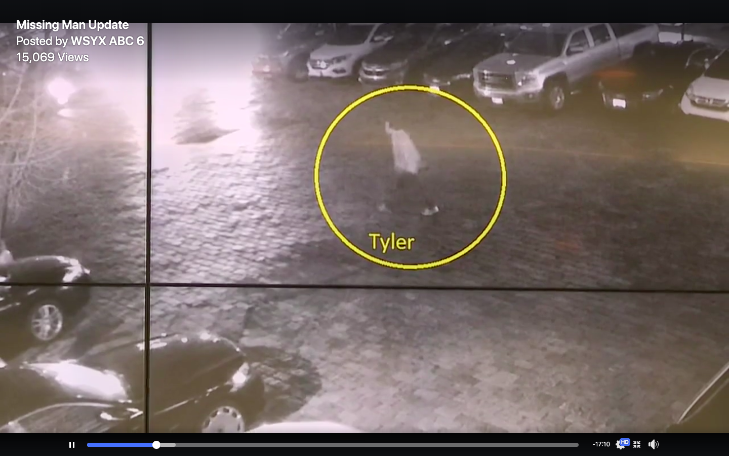
What we didn't have ofc is the still from the cctv and info on where LE searched. I have grabbed some images from the presser here for convenience:
Well there go all my theories.
So I don't understand. The digital trail of Tylers phone ended at the corner of the Abbott Labs parking lot at 3:53am. But yet, according to this link:
True Crime Society - Into thin air – where is Tyler Davis?
3:37am – Tyler calls Brittany. He apologizes and said that he is walking around the block smoking a cigarette and he will be right back. He explains that he was just pissed off and will see her in a few minutes.
After she gets off the phone with Tyler, Schon returns to the hotel. Brittany questions why Tyler isn’t with him. He says not to worry about it and that Tyler is just blowing off steam.
4:10am – Tyler is still not back at the hotel. He calls again. He says he is
walking through the woods and can see the hotel and that he will be there in 5 minutes.
4.11am final call, just an open line for about 4 seconds. When she cals back it goes straight to voicemail.
So 17 minutes after the last ping from the Abbott Labs parking lot is the final spoken call where Tyler tells Brittany he's walking through the woods. And 1 minute later a final silent call from Tylers phone.
Wow, now I understand LE focussed on the swamp and other wooded areas. Tyler had another 18 minutes actiradius from that parking lot. At least walking. Or if he got picked up, he could even have been further away.
DutchTreat
Well-Known Member
- Joined
- Jun 27, 2014
- Messages
- 1,534
- Reaction score
- 4,272
So after this shocking discovery that I had the whole timeline wrong, I have two major questions.
Why does the 'pinging' of Tylers phone end at the corner of the 'Abbott Labs' parking lot? If he called B at 04:11am there should have been a digital trail right?
And the million dollar question:
what directions do you get when you're at the very spot in the Abbott Parking lot where Tyler said: "Take me to Easton suits".
DutchTreat
Well-Known Member
- Joined
- Jun 27, 2014
- Messages
- 1,534
- Reaction score
- 4,272
I agree but only to a point. There a ton of wooded areas around that area so why go to the opposite end of that town when it seems that they know where he was at 3:53 am. Did somebody grab him at the far end of Abbott Labs parking lot at 3:53 am and drive him to the other end of town and dump him at Costco or over by Morse Rd? No, you grab him and drive on Stelzer drive the opposite way and take a right on McCutcheon Dr all the way to the Innus Park Alum Creek area which is right by Sunbury Rd. You don't drive into town with a body in your trunk. If he was grabbed at Abbott that's one scenario.
But how does he make a call at 04:11 in which he says to Brittany: 'I'm walking through the woods and I can see the hotel" if he was snatched at the parking lot? If he actually did walk over to the 'Costco woods/pond' and got snatched or had an accident there, he could very well be there.
And if he got snatched after the 04:10 call, he could be anywhere including the place you mentioned above.
The Night Watchman
Former Member
- Joined
- Oct 6, 2011
- Messages
- 1,193
- Reaction score
- 15,871
Good info all. Hmmm, what is the approximate time that Tyler's friend went to get Tyler, and said he saw him, and assured Brittany that Tyler would right back?
ETA- I think this was after 4AM, which puts him with Tyler around the time that Tyler went AWOL.
ETA- I think this was after 4AM, which puts him with Tyler around the time that Tyler went AWOL.
Last edited:
The Night Watchman
Former Member
- Joined
- Oct 6, 2011
- Messages
- 1,193
- Reaction score
- 15,871
Good info all. Hmmm, what is the approximate time that Tyler's friend went to get Tyler, and said he saw him, and assured Brittany that Tyler would right back?
ETA- I think this was after 4AM, which puts him with Tyler around the time that Tyler went AWOL.
Quoting myself for my error. DutchTreat's timeline above (836) says Schon returned around 3:40AM. Nevermind...
- Status
- Not open for further replies.
DNASolves
Online statistics
- Members online
- 184
- Guests online
- 1,143
- Total visitors
- 1,327
Totals may include hidden visitors.