Found Deceased CO - Suzanne Morphew, 49, did not return from bike ride, Chaffee County, 10 May 2020 #37

Status
Not open for further replies.
I did omit the space blanket and phone charger as being part of a large group, chances are the missing searcher would be found in short order. These are day searches from what I understand, not 24/7 until the subject is located like many SAR teams do. For large searches you have an Incident Command structure that is set up with communications, medical care, food, latrine facilities, signing each team out and back in, maps showing search grids and what team did them, etc.... It's quite the operation.

I am such a doofus! Trying to scan through a few cases too quickly, my eyes landed on the term missing searcher and I swear, my heart stopped. Lol Just goes to show you how important it is to read things thoroughly.
Do you guys think there’s very many people who might want to search alone, forego the entire operations and go check points of interest to themselves? I hope not. That’s what scares me the most because that person would be at greater risk if something went wrong leading to injury or getting lost...
Also, on a personal note: I’ve always thought that you @Trackergd is who I would most want to be on my case if I ever went missing out hiking, camping, etc. You have this all down to a science! Just sayin...
JMO
 
My speculation on the anomaly is what I’ve circled in yellow in this pic. It appears to be the ground sunken in that area.
yes, I saw that and agree. Does not look natural.
If you read about decomposition, some weeks after a body is planted, tissues liquify and body mass is lost at the rate of 5 lbs per day.
Indentations in ground is one of the giveaways to finding
buried bodies in SAR instructions.
 
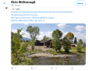
Thank you for finding that. Chris posted three pics that I’ll link below.

Twitter

Twitter

Twitter

My speculation on the anomaly is what I’ve circled in yellow in this pic. It appears to be the ground sunken in that area.

I’m also no rock wall expert but if you look at Chris’ first pic to see the build of the entire wall and then compare it to the right hand side where the sand has sunken, the right hand side does not appear to be similar to the rest of the build.

I wonder if that right hand side was even supposed to be part of the wall? It looks more like 6-8 rocks placed on top versus how the rest of the wall is more layered.
 
At least one thing MG and JP have in common is that they both worked at the Salida jobsite. Interesting that they were both selected by BM to beat feet to the Broomfield site. Was it because BM was afraid they might notice anomalies at the Salida jobsite?

MOO
 
Trial strategy is left to counsel's discretion. One of the most important decisions that the defense will make is what their overall strategy will be to create reasonable doubt. This decision is molded by the facts and circumstances of the alleged crime. Those will dictate what evidence in any particular case will create reasonable doubt and which theories may just plainly be viewed as unreasonable.

Here, the defense can, if it wishes to do so, try to present witnesses who testify about the traffic on CR 225 and may even introduce police reports showing prior accidents near Puma Path, if any exist. The defense may even hire an accident reconstruction expert to testify that it's possible that the bike's location was a product of some sort of collision. The problem is that the state will likely have its own accident reconstruction expert who will testify that it is highly unlikely that the bike would end up where it did as a result of a crash.

I brought up AM's mountain lion statement (mentioned by @TxGidget) because it would be much more difficult for the State to rebut this account. First -- assuming the witness can be located and subpoenaed -- it will be a sworn officer who would be testifying as to
having seen the mountain lion. Second, if the officer attempts to deny the mountain lion statement, then AM himself could be called to rebut the officer's denial (or -- if stipulated -- the video of the interview could be played for this purpose). Finally -- from a strategic viewpoint -- a jury would essentially be given an out: allowing jurors to "hang their hats" on a non-human cause of harm means that they do not have to assign blame to another human being, something which some people are very uncomfortable with doing.

Now, all this is not to say that the mountain lion theory -- even if buttressed by the testimony of an officer on the scene -- is infallible. I don't no much about mountain lions (here in indiana, there have been only two confirmed sightings within the last 10 years, and DNR believes it may be the same animal), but I would assume they would leave tracks or droppings; it is possible that the state could rebut the theory by having a witness testify that neither tracks nor droppings were found near the Morphew home.

All this is speculative, of course, but the revelation of the fact that an officer saw a mountain lion near the morphe home did appear to me to be a game changer in terms of a possible defense.
The ultimate problem with a mountain lion defense is that mountain lions can't and won't drag bodies very far, and that process (and the feeding process) is messy, leaving blood, drag marks, innards, and a carcass left within a mile of the attack. An expert will be happy to show the jury the photos of the last 7 or 8 fatal attacks in the States and Canada.
 
The area may not have sunk yet when the FBI was searching.
Way back when the news of MG 'raking' the beach area, we had photos of the beach area
w/ rake tine marks AND a few large rocks, BUT
there was an open area that had no big rocks at all and the wall was not totally across the beach area.
Anyone else recall this. ?? The beach area was totally different back then. So additional 'rock'
work has been done there. MOO.
 
Regarding the no trespassing signs along the river, signs like that are very common all along the Arkansas River. Without them, those type of spots look like a welcome rest/lunch spot for river rafters and kayakers. Regarding the depression in the soil along the wall (perhaps something else is being pointed at that I'm not seeing), it appears to me that it could have been caused by an eddy in river currents which fluctuate throughout the season. The downstream side of a boulder or rock can experience a lot of turbulence which can erode a lot of soil. In fact, the river flow upstream about 10 miles was about 5 times higher in cubic feet per second (around 1000 cfs at Nathrop) on July 1 2020 compared to how it is today around 200 cfs. See for yourself here: USGS Current Conditions for USGS 07091200 ARKANSAS RIVER NEAR NATHROP, CO. That being said, it couldn't hurt to have a search dog sniff around down there to rule out nefarious possibilities.
I agree, as a rafter, the vast majority of properties along that river do have no trespassing signs, absolutely zero to do with not wanting people to see something, but to keep us from taking lunch on their property (understandable). It would be unusual if they did not. Rafting season was somewhat better this year than the last two, with a higher flow for longer. I don't see anything being buried there, but MOO.
 
Who put up the no trespass signs and when?!?
Where should MG have raked or smoothed the ground with a machine? I'm seeing no space for using a machine? = double post, WS didn't want to send
-.-.-
What, if MG noticed some unusual things at the work site, asked one innocent question too many and therefore BM cut off the work and sent her home?
 
At least one thing MG and JP have in common is that they both worked at the Salida jobsite. Interesting that they were both selected by BM to beat feet to the Broomfield site. Was it because BM was afraid they might notice anomalies at the Salida jobsite?

MOO


could be. i always believed he wanted them away from the site, and salida, in general, for a few days, in case they noticed anything unusual, and that's why they were left hanging until tuesday.
 
Brother of Suzanne Morphew begins 6-day search in Colorado | 9news.com

SABBM:
Her brother, Andy Moorman and volunteers from Indiana are beginning a six-day search effort Thursday morning in Chafee County to search the mountainous area where she was last seen.

Volunteers are meeting at the Poncha Springs Visitor Center, located at 7010 US 285 in Poncha Springs to begin the search.

The mother of two is originally from Indiana, but moved to Colorado with her family a couple years ago, according to WTHR, our sister station in Indiana.

The Chaffee County Sheriff’s Office and the Colorado Bureau of Investigation are serving in a support role in Moorman's search effort and not in a lead capacity.

A candlelight vigil for Morphew is scheduled for 7 p.m. on Sept. 25 at Riverside Park in Salida.

Back in May, search teams combed through a construction site outside of Salida. At the time, investigators would not say if they found any evidence.
_______________________

6 days of grueling physical searching vs. a 27-second, incoherent video.

Such a stark contrast.

JMO.
 
Last edited:
Where should MG have raked or smoothed the ground with a machine? I'm seeing no space for using a machine?

Here is a screenshot from the Channel 9 News broadcast of May 22, 2020 which clearly shows the beach area., and a current screenshot from PE's Chris's Twitter feed. For accuracy, merely compare the three trees against the skyline. Today, there is clearly a sandy beach, but back on the eleventh day of SM's disappearance that entire sandy area was under high water. I thought I understood MG to say that she finished that underwater area off the day before SM' disappeared. When MG said BM told her to rake it out so the muck wouldn't show, just what could she possibly have meant?
It's bizarre, I think. IMO

Investigators search Salida property for missing Colorado mom | 9news.com
 

Attachments

  • Screenshot_2020-09-24 Search residential property in Salida.png
    Screenshot_2020-09-24 Search residential property in Salida.png
    811 KB · Views: 343
  • Screenshot_2020-09-24 Chris McDonough ( 187Cjm) Twitter.png
    Screenshot_2020-09-24 Chris McDonough ( 187Cjm) Twitter.png
    557 KB · Views: 277
I agree, as a rafter, the vast majority of properties along that river do have no trespassing signs, absolutely zero to do with not wanting people to see something, but to keep us from taking lunch on their property (understandable). It would be unusual if they did not. Rafting season was somewhat better this year than the last two, with a higher flow for longer. I don't see anything being buried there, but MOO.

I’m curious to get your opinion on this as a rafter:

If you look at the first twitter Pic that Chris posted that shows the entirety of the beach/wall, you’ll notice a build up of river rocks to the right of the beach.

Is a build up of rocks like that natural or would you think it is more likely to be part of the project work?

The reason I ask is that, it’s pretty common for that to be natural here in N.C. where I live based on the water flow. But in Chris’ pic, the build up of smaller river rocks (especially around the sandy area in question) does not look naturally occurring based on where the rocks are located.

Or said another way, are the rocks most likely naturally occurring in their location but something has disturbed the natural formation around that sandy area?
 
Status
Not open for further replies.

Members online

Online statistics

Members online
189
Guests online
4,157
Total visitors
4,346

Forum statistics

Threads
592,135
Messages
17,963,825
Members
228,694
Latest member
rebecca.ingram1214@gmail.
Back
Top