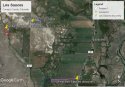
Here is a revised Google Earth Aerial View of Los Sauces, with both the first site, where one set of remains was reported to be discovered; and the second site, where two more sets of remains were reported found. The two locations are 2.0 miles apart by road.
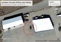
The first site is 18201 County Road 28 (GPS coordinates 37°15'24.36"N, 105°45'5.36"W)
The second site is 19086 CO RD 27 (GPS coordinates 37°16'13.70"N, 105°45'54.13"W)
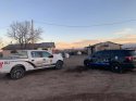
The sites do not seem to have anything in common, other than they are both currently vacant.
The map was produced entirely in Google Earth Pro with no external editing. Geo location was done by matching news photos provided to media by CBI to county assessor photos on the Conejos County Parcel Viewer (Assessor maps).
ArcGIS Web Application

 Ugh Horrible.