Nah, I usually can't remember any sources. That one I just ran across during my wild tangent searching.Thank you for finding this. You’re exactly what this case needs from time to time - A Thread Historian!


Nah, I usually can't remember any sources. That one I just ran across during my wild tangent searching.Thank you for finding this. You’re exactly what this case needs from time to time - A Thread Historian!
I didn’t know there was such a thing.BG obsevation: to me he is wearing motorcycle shoes.
A half mile from what point of thse bridge?
I didn’t realize barns had bedrooms and bathroom(s).2014
Police Calls | Carroll County Comet
April 26, 9:49 p.m. – Burglary, 5858W. 300N., Delphi. Ron Logan reported finding a person in his barn who was not authorized to be there. The unidentified person fled the barn prior to police arrival. The suspect was not located. Liggett investigated.
This is why I keep pushing an unpopular issue. If the girls were located around the bottom of that watershed ravine, it could vastly change how I look at the whole story. I'm not saying this is where they were at for sure, but it fits LE's descriptions better than anywhere else (if you believe LE). Imo. And, it sheds light on LE searching RL's property so much. In the end I'll likely be wrong, but that doesn't really matter.That puts them not just directly between RLs House and the creek, but also it literally places them in the wooded backyard of a residence on W300 N that is on the curve just past the intersection of 575.
That theory complicates things. As it is, it's pretty simple if he nabbed them at the end of the bridge, they ran across the creek and he got them.This is why I keep pushing an unpopular issue. If the girls were located around the bottom of that watershed ravine, it could vastly change how I look at the whole story. I'm not saying this is where they were at for sure, but it fits LE's descriptions better than anywhere else (if you believe LE). Imo. And, it sheds light on LE searching RL's property so much. In the end I'll likely be wrong, but that doesn't really matter.
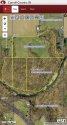
That location of the depression beyond the trees is likely one of the two areas the arrows are pointing at in this attached view.
You're certainly right. It does. I won't deny that, but I also can't bring myself to dismiss the things LE has said.That theory complicates things. As it is, it's pretty simple if he nabbed them at the end of the bridge, they ran across the creek and he got them.
I would mostly support this, despite what I've shown on the map. I agree the taped-off area looks maybe 1/3 acre and the interviews with LE making off-the-cuff distance calculations would definitely be estimates. Crime scene tape, flowers, RL interview, all point to that being the location. I could stop there.I wouldn't argue with anyone that said that the crime scene tape area was about 1/3 acre.
How far is it from the SE end of the high bridge to the SE end of the freedom bridge? I had no idea really. I looked at google maps and estimated it to be about a mile. I then measured it on google earth, and found it to be about 9/11th of a mile. About 1000feet less than a mile.
My point being, when LE gave these interviews, they didn't know what questions would be asked or have the luxury to use the internet or google maps or google earth to help them with their answers. They just happened to answer off the top of their heads. I don't think the exact distance was really important to them because they know where the crime scene is. It's just "a little ways" upstream from the bridge. Some people are better at estimating distances.
Also with the "hills" description, I see it kind of along the same lines. When he answered the question I doubt the detective was looking at satelite images nor topographic maps. I think he was just trying to describe what he saw from the crime scene. The crime scene tape area is in a fairly large low flat spot. I bet standing there it almost seems like you are surrounded by hills.
I think in general LE isn't very concerned about sharing super-detailed info with the media either. I see it as something like this: Reporter: "How far is it from SE end of bridge to crime scene?"
LE: (I really don't know, the exact number is really not important, I don't feel like trying to find out the answer, and I'm not sure I'd want to tell you if I did know the answer.) "About a half mile."
MOO
elphi Murders documentary (done recently, not the podcast), it's 23 mins in when one of the hosts, Barbara Macdonald, says she's walking down to and then standing at the crime scene.I wouldn't argue with anyone that said that the crime scene tape area was about 1/3 acre.
How far is it from the SE end of the high bridge to the SE end of the freedom bridge? I had no idea really. I looked at google maps and estimated it to be about a mile. I then measured it on google earth, and found it to be about 9/11th of a mile. About 1000feet less than a mile.
My point being, when LE gave these interviews, they didn't know what questions would be asked or have the luxury to use the internet or google maps or google earth to help them with their answers. They just happened to answer off the top of their heads. I don't think the exact distance was really important to them because they know where the crime scene is. It's just "a little ways" upstream from the bridge. Some people are better at estimating distances.
Also with the "hills" description, I see it kind of along the same lines. When he answered the question I doubt the detective was looking at satelite images nor topographic maps. I think he was just trying to describe what he saw from the crime scene. The crime scene tape area is in a fairly large low flat spot. I bet standing there it almost seems like you are surrounded by hills.
I think in general LE isn't very concerned about sharing super-detailed info with the media either. I see it as something like this: Reporter: "How far is it from SE end of bridge to crime scene?"
LE: (I really don't know, the exact number is really not important, I don't feel like trying to find out the answer, and I'm not sure I'd want to tell you if I did know the answer.) "About a half mile."
MOO
Apologies for that smiley face, unintentional.For anyone who's interested, On HLN's Part 1 Down The Hill
Parking was probably too limited. He likely has the pasture fenced off for his goats and horses; have we ever seen a pic of the front of his property? A lot of staging was done at the Mears place.One thing is that all the investigation vehicles were at the cemetery.
Had the CS been right behind RL's wouldn't those vehicles and activies, river search have been there?
Yes. A news helicopter flew continuously over the area on Feb 14.Parking was probably too limited. He likely has the pasture fenced off for his goats and horses; have we ever seen a pic of the front of his property? A lot of staging was done at the Mears place.
I can respect what you and others are saying about precise distance maybe not being important to LE. I can't see them calling less than a quarter mile a half mile when describing a relatively small distance, but that's only been my perspective as of lately. Like I said, the idea is problematic in other ways, and I acknowledge that. For me, though, in this matter, I'm going to look at each piece of information we have with both the south cemetery and points farther east in mind. I figure it can't hurt, since what I think about the case is really insignificant in the end, anyway. JMOI know LE is completely capable of measuring the distances. I just don't see how it is a critical piece of info. If they wanted to be precise, I think they would have said it was about 2600ft from the bridge as opposed to the nearest half mile. Or were they being precise? Maybe they were using sixty-fourths of a mile, but the distance just happened to be 32/64ths so they reduced it down to 1/2. If the crime scene was 80ft farther from the bridge would the official statement have been that it is 33/64ths of a mile from the bridge? I doubt it.
The hill statement: 2 hills on each side and another hill across the creek. That doesn't even make sense, or is at least somewhat ambiguous. 2 hills on each side of what? Each side of the crime scene? Ok. How many "sides" does the crime scene have? Well, what shape are we talking about? A circle? A square? An octogon? Say a square is the most likely option......4 sides......2 hills on each side......so there are 8 hills? Plus another one across the creek?
Also, I think 1/2 mile from either end of the bridge is off of RL's property. That "draw" or "ravine" on the east side of RL's property is about 3/8ths of a mile from the bridge, or about 600 feet less than a half mile. So why wouldn't LE say it was 3/8ths mile from the bridge? Are they rounding to the nearest quarter mile, and just happened to round it up (some 600 feet) to a half mile?
To me, it just doesn't make sense either way. If a half mile is a precise statement, then it is off of RL's property. If they are "rounding" the distance 600feet or more, then it is not a precise statement. Anyway, JMO. Keep fighting the good fight. May justice be served. The sooner the better.