AMBER ALERT TN - Summer Moon-Utah Wells, 5, Rogersville, 15 Jun 2021

Status
Not open for further replies.
I'm not questioning your information, but I would like to know how you know the field they were are searching. Thanks.
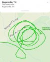
The flight number was posted earlier in the thread. When I entered the flight number into the Flight Aware app the flight path is showing with that green line, in the area described by the reporter's tweet. I took a screenshot from the app and posted it for those of you without the app to see.
 
I just looked up birds of prey of the kind we were thinking about. I am happy to report that they are known to hunt primarily in the mornings up until 10 am.
Unless someone observed them in the morning, or daytime, and didn't call it in till tonight.

<modsnip>

Indeed. It may have taken time to register with them and then they would doubt themselves and of course, likely want to minimize it. It could happen that way in many scenarios where they saw it in the am and didn't call until later. Maybe needed the spouse or friend to urge them on.
 
Oh geez. And no doubt that area has been searched previously. Tonight an intense search? <modsnip>
I don't like where this might be going.

In a word..YES. As they have expanded the ground search outward from 11 acres to close to 1000 acres in a perimeter. If I understand it was a 2 prong effort, the search and the official LE investigation. I am no pro, for sure. But I would think the investigating team would lead with their investigations into the acreas beyond what she could have traveled in that time period and kept the ground search a bit closer in. But I guess it is very easy for me to play Monday morning quarterback. I am just a curious person
 
The location that is being searched ...

At the 9 second mark of the video in this reporter's tweet you can see the steeple portion of the Mt Carmel Free Will Baptist Church come into view on the left of the video (you will also see the Church's sign - it is square):
https://twitter.com/overbay_ted/status/1406471518163513347

On Google Maps StreetView, this is the closest position to where that video was taken from (actually the reporter/videographer would be on Fields Rd right where it intersects Beech Creek RD and looking NNW.

https://www.google.com/maps/@36.4280897,-82.7261467,3a,75y,63.3h,96.71t/data=!3m7!1e1!3m5!1sdMrokl2_PC8T8pnZVkpjaA!2e0!6shttps://streetviewpixels-pa.googleapis.com/v1/thumbnail?panoid=dMrokl2_PC8T8pnZVkpjaA&cb_client=maps_sv.tactile.gps&w=203&h=100&yaw=150.13255&pitch=0&thumbfov=100!7i13312!8i6656?hl=en-US

The helicopter in the sky is further to the north of the Church above the field just past the Cemetery.

Google Maps
 
Status
Not open for further replies.

Members online

Online statistics

Members online
161
Guests online
4,116
Total visitors
4,277

Forum statistics

Threads
591,847
Messages
17,959,950
Members
228,622
Latest member
crimedeepdives23
Back
Top