Found Deceased Spain - Esther Dingley, from UK, missing in the Pyrenees, Nov 2020 #7

OK @RickshawFan. I finally understand your blogger, Montesymasdebucuesa: 42-14. PICO DE LA GLERA POR LA ARISTA SUDOESTE. 6-6-14..

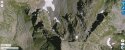
So I reconfigured my graphic yet again (#3, :)), with the north(west) ascent from Port dl Glere up Pic dl Glere, per your reference to the blogger's statement: “The Pico de la Glera has an easy ascent from the Puerto de la Glera through a stepped ramp on the north face that leaves you practically at the top”. He took the Southeast route.

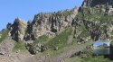
I doubt ED made it to the top, as does @Federico_A (per his X on insert image). And I think instead of summiting, ED stopped at that large boulder / ledge I have circled in red... from there she may have fallen to her death or fell post mortem to the next boulder / ledge I circled in yellow, concealed from the port and scree field below.

View attachment 309266
Exactly. All that you say. Great that those boulders have been picked out. Remains could definitely have become hung up there. They seem a very likely location. I doubt ED was going to get far up that crazy cliff edge to the Pic with those shoes on. And climbing may have been much more difficult if fog rolled in and made the cold rock frosty.
If ED went up this way from the Port, the ascent might have been a matter of opportunity. She said her destination was the Port De la G. She got there, saw the ascent “trail”, and simply got drawn up it. She may actually not have known about the vast scree slopes below. If she came up the Spain side, she might have assumed the Pic was a whole mountain, when, in fact, almost half of it has sheared off into the valley below.
So, she seems to have gone 400 meters up that trail? Or is the 400 meters walking up from where the skull was found, to the Port, and then the ascent on the flank of the Pic being whatever is leftover from the 400? We’re basically working with a triangle.
 
Ok, when I originally followed all the information through I came up with this image, and effectively in line with @RedHaus hypothesized that the cyan oval -or just above was the most likely endpoint (note I had to adjust the line as the upper yellow line is 20-30m down and the lower line with the ovals is 30-50m, possibly slightly low)
25m below Pic Glere.png
However when you look in conjunction with Dan's walking route map it is the area in the white oval that appeared just before he found her.
upload_2021-8-17_16-3-3.png
The scale is different but basically this is where my red oval is or just to the right....
My first thought on the Pic is that "I wouldn't even attempt to climb up there", then it seemed plausable that there was a small path leading to an outcrop lower than the Pic, but this doesn't square with DC's last hikes when he found Esther.

Secondly, as far as I am aware there has been no indication of the sleeping mat being inflated, or indeed out of it's stuffsack, just that it was out. If anyone has a link then please post, but IMO it is 'merely' that the pack has been torn open by rocks or animals or was open when the incident occurred and the contents scattered.
 
That view of the cairn and grassy saddle is actually on the Spanish side - seems they came down that way.
No, it's definitely in France. That large square rock shoulder to the right of the picture is the same one visible here from the Sun article:

https://www.thesun.co.uk/wp-content/uploads/2021/08/NINTCHDBPICT000672845289.jpg

http://ekladata.com/o5fuN0YfuU0q9zEEEkVTGoS04ZM.jpg

That's low on the scree slope on the French side. The shoulder is the bottom of the ridge that runs up to the Pic de Sacroux. The pictures in that gallery are also roughly chronological, so it's before they begin climbing the scree in earnest.
I still don't believe Esther did it either way. The summit section is actual climbing and even these guys with an ice-axe were having trouble, and, significantly, it took both of them to do it. And we would have to believe that DC made it up there himself all the while assuming that Esther was not one to leave the path.
DC located Esther's remains: he didn't reach them. It's not even necessary to assume that he reached the point she fell from. He reached a point from which he was able to see them.
I'm not even sure why we're considering that she ascended Glere. I think it was just sloppy journalism that made it sound as if she did. Am I the only one who thinks "400m below Glere" means horizontally rather than vertically?
What's the source of the 400m figure?
 
Last edited:
So, she seems to have gone 400 meters up that trail? Or is the 400 meters walking up from where the skull was found, to the Port, and then the ascent on the flank of the Pic being whatever is leftover from the 400? We’re basically working with a triangle.
What's our source for the 400m figure?
 
I've come to realise that those Google images bear little relation to reality. All the rough edges are flattened out and everything looks easy. Even the summit of Glere is rendered as a flat table-top. Fact is, that mountain is all vicious crags higher up and it's definitely a climb, not a hike.
Right. Google Earth applies aerial photography as a skin to a smoothed polygonal landscape derived from contour data. That works pretty well on a large scale, but not for craggy details. Compare the smooth ridge of the Pic de la Glère with its jagged shadow cast on the screes below.
I'm back to point X as the simplest thing that explains everything, and there seems to be no case against it.
My main objection is that I think the cliff at the foot of the fall is too exposed. I've just realised that the French climbers' blog actually shows that area in some detail:

http://ekladata.com/i-tvmz0852UQTCS5C2QXaYcwL6Q.jpg

http://ekladata.com/v5oFxI3yhir-QyCyY7dQXQbgRO8.jpg

http://ekladata.com/WXNpEuqeHV0gXNVQ4Basfnbi4nw.jpg
 
Last edited:
What's our source for the 400m figure?
Various articles like this Hiker Esther Dingley ‘fell 100ft to her death after losing footing’ "the remains... found about 400m from the top of the Pic de la Glere".

I see that point X is actually only 300m from the peak as the crow flies (permissible error?) but that the place where the skull was found is actually 400m from the peak (by crow) so not sure if they actually meant that instead. I can well believe that the reporter, not understanding the topography, garbled the whole thing.

I've think I've seen different wording on it, but however that 400m is interpreted, it means Esther was nowhere near the Glere peak.
 
Lots of good work in the last couple of pages of the thread

To me her exact path doesn't matter so much. I think it's pretty clear she was on the ridge line, fell down into the scree field and came to a halt against some rock or ledge, such that she can't be seen from the pass or from the trail. To see her you have to get up above - e.g. on the ridge line, or on the field - which explains why she wasn't found earlier.

Especially earlier searches would be looking for her downhill from the path - not uphill.
 
Right. Google Earth applies aerial photography as a skin to a smoothed polygonal landscape derived from contour data. That works pretty well on a large scale, but not for craggy details. Compare the smooth ridge of the Pic de la Glère with its jagged shadow cast on the screes below.

My main objection is that I think the cliff at the foot of the fall is too exposed. I've just realised that the French climbers' blog actually shows that area in some detail:

http://ekladata.com/i-tvmz0852UQTCS5C2QXaYcwL6Q.jpg

http://ekladata.com/v5oFxI3yhir-QyCyY7dQXQbgRO8.jpg

http://ekladata.com/WXNpEuqeHV0gXNVQ4Basfnbi4nw.jpg
Difficult to see from those - the cliff is further to the right. I haven't yet seen a good picture of the French side of the ridge so I'm guessing that means it's just not visible from below.
The cliff does seem quite sheer in one picture but it was from a long distance away and I'm just supposing that there are some projections below point X behind which she fell where she was wedged against the 'wall' that was mentioned.
 
Last edited:
I'm not even sure why we're considering that she ascended Glere. I think it was just sloppy journalism that made it sound as if she did. Am I the only one who thinks "400m below Glere" means horizontally rather than vertically?

RSBM

No. I agree with you. I think the 400m means she was nowhere near the peak.

She fell 'only' about 30m vertically - off the ridge. I don't think she was engaged in any seriously climbing. Rather she just accessed the ridge in what is a step goat climb rather than serious climbing, then just slipped off

The treacherous trail in the screefield is one that allows you to get close to the body - but that can't be where she fell from
 
That's an awesome pic, too @OEJ-JEO... :) I think what struck me with the latest one from Federico_A is I could actually see an ascension path from Spain, where she may have been before she fell... and then where she may have landed. The photo you have here has all that French side of the pic in shadow... and Federico_A's did not.

upload_2021-8-17_16-20-16-png.309190


Please let me know if I missing something...
You might be right. My red line would be nearer to us, between the two patches of scree.

See picture attached. The just-visible path on the left goes up through a couloir to point X. Further to the right, where your line is, looks quite doable in this picture, and she could have got up to that corner of the skyline. No path though that I can see, and a bit more effort perhaps, and even less than 400m from the pic, but it's surely a possibility.
 

Attachments

  • Clipboard Image.jpg
    Clipboard Image.jpg
    193.4 KB · Views: 62
Various articles like this Hiker Esther Dingley ‘fell 100ft to her death after losing footing’ "the remains... found about 400m from the top of the Pic de la Glere".
That article is quoting the Mail Online article mentioned previously, and gives the same mistaken figure of 2300m for the altitude of the summit. The Mail article is such a jumble of contradictions that to pluck one figure from it is almost certain to be misleading.
I've think I've seen different wording on it, but however that 400m is interpreted, it means Esther was nowhere near the Glere peak.
That's what's makes me discount it. The one consistent piece of information is that the Pic de la Glère is where Esther's remains were found. Precisely where on the Pic isn't clear, but the 400m figure really sheds no light at all.
 
Last edited:
Difficult to see from those - the cliff is further to the right. I haven't yet seen a good picture of the French side of the ridge so I'm guessing that means it's just not visible from below.
I think that trips up the scree slope towards the Pic are rare! And the one that we've discovered is focused on the climb, not on the surroundings.

I think it's probably not possible to see the base of the cliff at your point X from the normal trail to the Port, but I do think it would be visible from higher up the scree. In fact, I think it's somewhere to the right of this picture, well below the point where the two couloirs diverge. To me that seems more accessible than the procureur suggested when describing the site. I think a point higher up the right couloir where it narrows to a gully would be a better fit.

Impossible to be certain, of course.
 

Attachments

  • geoportail pic.jpg
    geoportail pic.jpg
    136.4 KB · Views: 42
Snipped for focus.

You're sure about that, TheI, lol? Can't happen? I agree now that I look at my imagined scenario that does seem quite funny, about landing on a marmot. Or maybe the pack landed on the marmot? Falling rock?
Would they be up that high? I’ve only ever encountered them in grassy lower areas.
 
Incidentally, the "grassy saddle" mentioned previously seems to be the feature above the prominent tooth-shaped rock on the left couloir here:

http://ekladata.com/v5oFxI3yhir-QyCyY7dQXQbgRO8.jpg

I found a web forum entry by one of the two Frenchmen describing the climb:

J'ai bien un topo guide Ollivier....mais c'est succint....

"emprunter à gauche un large couloir de neige ou d'éboulis qui permet d'atteindre un éperon d'où l'on gagne le sommet"

Dans l'axe de ce que nous avons choisi comme cheminement, on voit parfaitement sur la gauche, le gros piton rocheux, avec le col herbeux, les pentes herbeuses à gauche qu'il faut suivre pour prendre pied sur l'éperon et le remonter....(ce qui correspond effectivement à la description du guide Ollivier....)

If this is all French to you, help is near:


I do have a guidebook from Ollivier....but it's brief....

"Take a wide snow or scree corridor on the left which allows you to reach a spur from which you can reach the summit".

In the axis of what we have chosen as a path, we can see perfectly on the left, the big rocky peak, with the grassy pass, the grassy slopes on the left that we have to follow in order to get a foothold on the spur and climb it....(which indeed corresponds to the description of the Ollivier guide....)
 
Ok, when I originally followed all the information through I came up with this image, and effectively in line with @RedHaus hypothesized that the cyan oval -or just above was the most likely endpoint (note I had to adjust the line as the upper yellow line is 20-30m down and the lower line with the ovals is 30-50m, possibly slightly low)
View attachment 309277
However when you look in conjunction with Dan's walking route map it is the area in the white oval that appeared just before he found her.
View attachment 309278
The scale is different but basically this is where my red oval is or just to the right....
My first thought on the Pic is that "I wouldn't even attempt to climb up there", then it seemed plausable that there was a small path leading to an outcrop lower than the Pic, but this doesn't square with DC's last hikes when he found Esther.

Secondly, as far as I am aware there has been no indication of the sleeping mat being inflated, or indeed out of it's stuffsack, just that it was out. If anyone has a link then please post, but IMO it is 'merely' that the pack has been torn open by rocks or animals or was open when the incident occurred and the contents scattered.
I’m confused here because in the marked up Google Earth photo, the label for the Pic is not on the Pic. This would presumably throw off the circles.
 
If this is all French to you, help is near:
The problem here is that they’re walking on snow. That can be very misleading. You can climb many places in snow that you can’t without it. IMO we’d have to get a blog where there’s no snow to get the ascent line.
 
I’m confused here because in the marked up Google Earth photo, the label for the Pic is not on the Pic. This would presumably throw off the circles.
I think the summit location is labeled correctly, but the distortions caused by the software are confusing. View it in 2D to figure it out.

The highest point (2496m) on the summit system is where four ridges converge: the sharp arête that runs out to the east, the short summit ridge that runs west, the nobbly "spine" spur that runs northeast, and the rugged spur that runs down onto the scree to the north. What looks like the summit in the big picture I posted before is just the end of the summit ridge. The true summit is out of sight, about 50m beyond it to the east.

At the western end of the summit ridge, there are another two ridges: the one that runs south that the Spanish guys came up, and the other one that runs NW to the Port.
 
Last edited:

Staff online

Members online

Online statistics

Members online
218
Guests online
3,144
Total visitors
3,362

Forum statistics

Threads
591,826
Messages
17,959,647
Members
228,621
Latest member
MaryEllen77
Back
Top