Elley Mae
Well-Known Member
- Joined
- Jul 9, 2008
- Messages
- 21,941
- Reaction score
- 45,665

Follow along with the video below to see how to install our site as a web app on your home screen.
Note: This feature may not be available in some browsers.


Henry, what does "Initialzed at 12z" mean? Is that the time of day the chart was run? I've seen multiple charts with differing z's, and was thinking if it was time, that I might be able to figure out more on these charts.
:tyou: all for posting the visuals! And yep, will be interesting if Euro/US/Canada pan out to be more correct as iirc the Euro model was right on target for Harvey.
12z, 0z, etc.- These are timing signals for models, essentially done in military time with 24 hours. The main model times are 0z, 6z, 12z, and 18z, though most models come out at 0z and 12z. New data is taken officially every 12 hours, as 0z and 12z, which is why those are the two model runs with fresh data. /[/url]
12z, 0z, etc.- These are timing signals for models, essentially done in military time with 24 hours. The main model times are 0z, 6z, 12z, and 18z, though most models come out at 0z and 12z. New data is taken officially every 12 hours, as 0z and 12z, which is why those are the two model runs with fresh data. The timing is actually that in London, where the first weather balloons were launched and timing needed to be standard across the globe for weather. Thus, 0z is midnight in England and 7 PM during winter in SW CT. 12z is noon in England, 7 AM here in SW CT. Models come out anywhere between 2 and 6 hours later than the timing in z shows they will, but the time stamp just shows what data was input.
https://swctweather.com/weather-glossary/
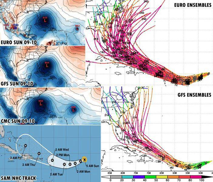
Cariis- looking like an East coast event...although hurricanes have a mind of their own and change it regularly.
http://spaghettimodels.com
Sent from my VK815 using Tapatalk
Yep....2 out 3 are NC. Just a slight movement in the high out in the Atlantic and we have a different result. Canadian it's the odd man out on this run with Florida although the other 2 are running it up the coast. Feels a bit like Matthew all over again.I agree and the water is really hot now
N Carolina??
Your welcome. [emoji3] Hurricanes are one of the few weather events that we can see coming in time to prepare.Henry, :tyou: for putting it all into one jpeg daily and/or 2x a day so I can send to those that are going to have to make travel plans around this storm next week! :blowkiss:


Henry, :tyou: for putting it all into one jpeg daily and/or 2x a day so I can send to those that are going to have to make travel plans around this storm next week! :blowkiss:
Yep....2 out 3 are NC. Just a slight movement in the high out in the Atlantic and we have a different result. Canadian it's the odd man out on this run with Florida although the other 2 are running it up the coast. Feels a bit like Matthew all over again.
http://spaghettimodels.com
Sent from my VK815 using Tapatalk