Dr did not report this information to police. He in fact did not recover this memory until he was under hypnosis later.
Sent from my iPhone using Tapatalk
Probably half asleep I would imagine.

Dr did not report this information to police. He in fact did not recover this memory until he was under hypnosis later.
Sent from my iPhone using Tapatalk
Dr did not report this information to police. He in fact did not recover this memory until he was under hypnosis later.
The second location that Sigrun pointed out looks similar to the video. I haven't been able to use the ground view on google maps for the third location that Sigrun gave. So I couldn't see what it looked like when you actually drove on the road. That looks like like it might be also be similar. I did a screen grab of the video. I'll try and clean it up in Photoshop. Might be able to see something I didn't at first.
45.463478, -94.504091 -second location link
45.469973, -94.478737 -third link. Very isolated. Gravel pit of some sort.
Video link.
http://minnesota.cbslocal.com/2014/05/15/abduction-victim-speaks-out-on-wetterling-case/

I tried to lighten up and sharpen a screen grab of that video. I'll try and post it....sorry if it doesn't work. I've never posted pics on here. There's a spot near a church that looks similar when compared to the area in the video. Coordinates for that are below.
45.455911, -94.475739
Video was from this link
http://minnesota.cbslocal.com/2014/05/15/abduction-victim-speaks-out-on-wetterling-case/
Yes, I see what you mean. Now, compare this to the one I posted, but move the red marker out to the highway. Same view.
This site:
1. It is not 5 miles from Cold Spring. It isn't even 2 miles (Star Tribune)
2. It is not anywhere near Richmond Ball park, but they supposedly stopped "shortly after that" according to the search warrant. Thus, to be here they had to go west 2 more miles, then come back toward Cold Spring another 2 miles to this location.
3. According to news sources there was a silo. I don't see any silos anywhere around in the 1991 imagery.
4. It is not north of Richmond, it is almost due east, about halfway between Cold Spring and Richmond
Site I posted:
1. 3 miles as the crow flies, 5 by road
2. One silo as indicated
3. One pole light, as indicated
4. "Shortly after" the Richmond Ball park
5. North of Richmond
I think I see why it is confusing now. Yes, the coordinates you gave are the Church I posted and asked about earlier. Not sure what to make of this. But if shergal didn't use this video, and this is the correct site, what information did she base it on? It does not comport with any of the information in the search warrant or news sources. So, very baffling indeed.
Observations: this site makes disposal of remains in place more likely. The site I found makes it less likely. jmo
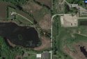
It is 45.463478, -94.504091, second link as you said. I verified it by comparison to the video. It was also the best candidate and is the only site that fits all the reliable info we have. I verified this with the video by expecting to see a fork in the road, which I did. In the 1991 imagery you can see it. Also, in 1991 all those trees on the left were not there. The right fork goes to a farmhouse, the left fork goes into the "pines" (the woods). I suspected this is where JS was taken, and I suspect the new POI shot JEW here (jmo so far). The right fork was a mixture of gravel and dirt, the left fork was dirt. The silo is to the left of the video image but you can't see it for the trees that are there now. Here is the overview. The locator shown is a little off as they were further into the drive than this, just beyond where it forks:

Looking at the enhanced video, I'm thinking this shot is of the drive at the highway, but now not sure if it is the Church or the property I posted.
I tried to lighten up and sharpen a screen grab of that video. I'll try and post it....sorry if it doesn't work. I've never posted pics on here. There's a spot near a church that looks similar when compared to the area in the video. Coordinates for that are below.
45.455911, -94.475739
Video was from this link
http://minnesota.cbslocal.com/2014/05/15/abduction-victim-speaks-out-on-wetterling-case/

I know. They're so close when you're on street view. From the air it looks like they should be different, but turning in on street view......I don't know. Once you take into consideration the time difference in the photos/videos. Trees not having leaves in the enhanced one. Like you said below. Very baffling.

What is really baffling to me is why all those details about the location appear to be wrong. Here is the 1991 imagery of the site you found:

Yes, I see what you mean. Now, compare this to the one I posted, but move the red marker out to the highway. Same view.
This site:
1. It is not 5 miles from Cold Spring. It isn't even 2 miles (Star Tribune)
2. It is not anywhere near Richmond Ball park, but they supposedly stopped "shortly after that" according to the search warrant. Thus, to be here they had to go west 2 more miles, then come back toward Cold Spring another 2 miles to this location.
3. According to news sources there was a silo. I don't see any silos anywhere around in the 1991 imagery.
4. It is not north of Richmond, it is almost due east, about halfway between Cold Spring and Richmond
Site I posted:
1. 3 miles as the crow flies, 5 by road
2. One silo as indicated
3. One pole light, as indicated
4. "Shortly after" the Richmond Ball park
5. North of Richmond
I think I see why it is confusing now. Yes, the coordinates you gave are the Church I posted and asked about earlier. Not sure what to make of this. But if shergal didn't use this video, and this is the correct site, what information did she base it on? It does not comport with any of the information in the search warrant or news sources. So, very baffling indeed.
Observations: this site makes disposal of remains in place more likely. The site I found makes it less likely. jmo
Thanks shergal. Now that I'm caught up I'll continue with where I was hoping to go with this. If anyone is interested in helping, I’d like to know your opinion on these items I was wondering about until now:
1. Given the layout, what are the odds that this is the same place the POI took JEW, keeping in mind that JEW was never released, never escaped and was never seen after being abducted?
2. Given the layout, how likely is it that JEW died at that location?
3. Does the JS assault site have any salient features that might indicate what kinds of properties JEW might have been taken to, if not this one?
4. Given the exact location of this property, what are the odds that the new POI, given what we know about him, would have taken JEW from DR’s driveway to this place?
5. Is there anything about this property to suggest the likelihood that the POI might leave human remains in place (mostly) rather than transporting them; considering the means available to this POI to control and/or destroy evidence.
6. And yes, what are the odds that an attacker at this site could discharge a handgun at least once and not expose his activity there?
A poster earlier used the phrase “arc of violence” and it struck me how appropriate that phrase here is.
This POI began as a small town pervert, a caricature of “Chester”, and proceeded on a natural arc of violence from
a. Groping
b. Knocking prepubescent boys off their bikes
c. Threatening them with a knife
d. Threatening them with a firearm
e. Threatening them with a firearm and brandishing one as well
Jmo, but the simplest explanation with the least number of assumptions given what we know is:
1. That the POI is a person with a gross misapprehension of risk. The police have noticed this, too, in pointing out how brazen and reckless his actions were.
2. Related to 1, this POI was and is supremely confident he cannot be caught.
3. On his continued arc of violence we see an increasing frustration of this POI in each case as a result of his being unable to satisfy his urges: this POI was unable to control his urges.
4. In JEW’s abduction he brought what appeared to be a loaded handgun, threatened to use it and brandished it.
5. On abducting JEW, the POI intended to visit upon an 11 year-old child an evening of shock, confusion and terror.
From this it isn’t hard to predict the outcome. It should really come as no surprise that JS was released and JEW was not. It hinges on this arc of violence and how far the POI took it. This is all in hindsight and the victims had no way of knowing this, but it is all too clear now. In other words, we could treat both the JS abduction and the JEW abduction as copy-cat acts save for the POIs arc of violence from one victim to the next.
I believe that DH did feel it was risky to continue his attacks locally as he stopped and moved elsewhere. He clearly escalated his MO. He also went from city streets to dark and quiet dirt/gravel roads in the country. I believe that he thought DR's driveway was a road or he would have backed in or turned all the way around to get away quicker. If he thought it was a road, he may have thought he was going to continue down the road to assault JW. When he had to turn around in DR's driveway, he knew he had to re-think his plan. Maybe he did go somewhere that he knew he had privacy? If he did go to the same location where he took JS, I recall it had an old pond that was filled in. I don't remember where I saw that but they should certainly check there.