LadyInRed09
New Member
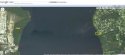
Here's another boat ramp with public access:
St. Johns River--Elgin Grove (#30)
Head north on SR 207 from intersection of SR 207 and SR 100. Go 4.1 miles to SR 207A. Turn left on SR 207A and follow 4.3 miles to East River Road. Turn left and go one block to Magnolia Avenue. Turn right and follow Magnolia Avenue 0.4 mile to ramp at end of road.
Single-lane ramp with unimproved parking capable of accommodating 10 vehicles.
http://myfwc.com/RECREATION/boat_neramps.htm#putnam
ETA:
This Magnolia is in East Palatka. If you look directly across the St John's River, you'll stare into the yard of ........... PDM.
Yes. Directly across the river.
Well, that's mighty interesting.
WHY do I get the feeling this is where the boat comes in to play.....?