MimosaMornings
Well- Known Member
- Joined
- Apr 10, 2018
- Messages
- 7,916
- Reaction score
- 61,757
Oh geez, what was so important they had to go out for 30 minutes? Pull up crab traps?What was so important that they needed to go out an inlet, with an incoming storm that was known to have 3-4’ surge, in a 20’ boat?!?! I’m baffled.
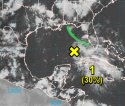
Cristobal brings flooding along Gulf Coast, Coast Guard searching for 2 missing boaters
The Coast Guard said in a news release that Ted Roach and Jennifer Lingoni left Salt Bayou near Slidell, La., at 1 p.m. Sunday on a 20-foot yellow skiff and were scheduled to be back at approximately 1:30 p.m.
Wouldn’t there have been small craft warnings?
Of course I’m amazed when people are surprised that it’s flooding - um, they’ve been talking about a tropical storm for several days now.
") After that...?
After that...?