I’ve read and heard enough now to believe Theo was confronted by a youth gang down the end of Tennyson Street (eshay style thugs), and it seems the Byron Bay community and Police are so intimidated by them that they will not address this probable scenario for fear of repercussions. Yes, the local police have kids/families too, so I kind of understand their hesitancy. The following article and the replies from parents are disturbing to read what is/has been happening in the Byron area for a number of years now.
Eshay-style thugs heading nowhere without intervention – Echonetdaily
The police appear to be too intimidated to interview these known youth gangs about Theo’s disappearance and it seems from the article above, that nobody would be willing to report them either for fear of reprisal. So how can we ever find out what happened to Theo if only the gang members know, the locals won’t report to the police, and the police won’t confront them?
I’ll take it as fact that Theo was confronted by a gang for 7 minutes that may have included escalation to try and make him fight. Perhaps he got away and was chased up Milne Track, and possibly caught where his hat was found, and then taken to CC, or otherwise was chased all the way to CC where he tried to find a route up the steep bush behind the beach, but was brought back down to the beach. This gang could then have made Theo tell them his passcode to unlock his phone for future use/or to sell for money, and between them, worked out a little plan to send those short messages back to family/friends.
From there, it is still possible a 4WD was used to take him away, or thrown in ocean. Not sure if ‘The Judge’ is related. Could have belonged to one of them.
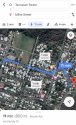
These gangs are from South Golden Beach and Ocean Shores, north of Byron Bay Town Centre.
I am so sorry to Theo’s family for writing this, but it is just what I feel is close to what happened.


") (dang it)
(dang it)