CA CA - Bill Ewasko, 66, Joshua Tree National Park, June 2010

Haven't looked at maps to determine where this is exactly, but Bill Ewasko always comes to mind (now that Paul miller has been located):
Human skeletal remains found in Joshua Tree National Park

Thanks for posting.
I had to go back and check when Paul Miller was found and it turns out he was found Dec 20th but it wasn't confirmed as him until January. So this is a new set of skeletal remains found a remote area on Jan 16th. It also says "SBCSD did not specify where in the park the remains were found" so we can't compare maps yet. I hope that Bill has finally been found. :(
 
Last edited:
A couple more links on the bones found Jan 16th say the remains were found "near" the park instead of saying in the park. Here are some quotes on the location of the unidentified remains:

"A hiker reported finding a partial human skeleton in Section 6, said Cindy Bachman, a spokeswoman for the county Sheriff’s Department.

Section 6 is roughly a square mile of undeveloped land east of Quail Springs Road, outside the western border of the park."

Human bones found in Joshua Tree near national park

"Officials did not find any obvious signs of foul play or personal belongings nearby, SBCSD spokeswoman Jodi Miller said. There were no active searches for missing persons in the area at the time of the discovery. Investigators were uncertain how long ago the person had died or how long they had been at that location.

The partial skeleton was found just outside of federal land in the Desert View Conservation Area, which is near the town of Joshua Tree and north of Quail Springs Road, Joshua Tree National Park Superintendent David Smith said."

Partial skeletal human remains found near Joshua Tree National Park – Daily Bulletin
 
Here's a map of where Bill's car was found (Juniper Flats) and the approximate area where the unidentified remains were found Jan 16th (Desert View Conservation Area): Google Maps
It's about 13.9 miles to walk and it's in the opposite direction from where Bill told his girlfriend he was interested in hiking (Carey's Castle).
 
I was one of the people that participated in Tom Mahood's crowdsourced search effort.

Since 2019 I've been doing a webseries around hiking, exploration and travel called ADAM WALKS AROUND. It mostly takes place in Asia. Since I'm stuck in California during the pandemic, I decided to devote an episode (the 36th in the series) to retracing Bill's disappearance.

The show is not a true crime show (though if people find the show interesting you're welcome to subscribe, I would love that), but within the format, I tried to make an accurate overview of the case and also learned some things I didn't realize in going over the ground where Bill apparently disappeared.

If anyone has any questions about Bill's disappearance or about the video, I'll try to answer them as best I can.

The link is here:
 
I see that Tom Mahood is assuming that he’s been found:

“Mahood added: "While we now know the conclusion, we may likely never know any details unless Bill left behind any surviving notes as to his predicament."”

And, answering my curiosity about just where the bones were found, in relationship to the searches:

Mahood studied the path of the helicopter that went in to where the bones were found, and said that the location didn’t make any sense.

"I always said, he'll eventually be found in someplace no one ever thought he would be," said Mahood via email. 'Something Richard Feynman described as a 'failure of imagination.' "

Human remains found at Joshua Tree; do they belong to Bill Ewasko?
 
Wow, I really never thought he'd be found. Feels like a good time to reread Tom Mahood's blogposts; I hope he posts his thoughts about the find once he's able (as it sounds like there are some details currently being kept secret).
 
Wow, I really never thought he'd be found. Feels like a good time to reread Tom Mahood's blogposts; I hope he posts his thoughts about the find once he's able (as it sounds like there are some details currently being kept secret).

Assuming that it’s him, I wonder where he was, compared to where his car was parked, compared to the paths of all the places he wanted to see, etc.
 
Body Found in Joshua Tree National Park May Be Hiker Missing Since 2010

Hikers found the body on Tuesday in the park’s northwest corner, near the Panorama Loop Trail. Park rangers and deputies from the San Bernardino County Sheriff’s Department secured the scene overnight, with a crime scene investigation team arriving at daybreak on Wednesday.

...
Along with the body, investigators found a wallet with identification belonging to Bill Ewasko, a 66-year-old man from the Atlanta suburbs who went missing in June 2010, a report from local radio station KCDZ said.

...
Two days later, a California Highway Patrol helicopter located his car at the Juniper Flats trailhead, a 90-minute drive from where Ewasko had originally planned to hike.

@wary maybe some of the information in this article help understand more
 
From that long 2018 NYT’s article, three days after he disappeared his phone pinged from a tower near the Northwest corner of the park.
Turns out that’s where he was, after all.
BBM

Tragically Lost in Joshua Tree’s Wild Interior (Published 2018)

Included in Mahood’s trove of information were some enigmatic cellphone records. These records reveal that, at 6:50 a.m. on Sunday, June 27, 2010, three days after Ewasko last spoke with Mary Winston, his cellphone communicated with a Verizon tower just outside the park’s northwestern edge, above the town of Yucca Valley. This was the first time Ewasko’s phone had registered with any towers since the morning of his disappearance, suggesting that his phone had been turned off until that moment to conserve battery life — or that he had been trapped somewhere without service. The ping was a welcome clue, one that shaped several new routes during the official search operation, but it also presented a mystery: According to this data, Ewasko’s phone was 10.6 miles away from the tower at the time of registration. This placed him so far beyond the official search area that, when rescuers first learned of the ping in 2010, many simply did not believe the data.

As for why his phone pinged only once that morning, there was one especially frustrating theory. Some hikers speculated that perhaps Ewasko finally reached a high-enough point where he was confident he could get a clear signal. He had spent three nights alone in the wilderness; he would have known his phone had little power left. He would have turned his phone on, hoping for coverage — and he found it. But any joy was short-lived: An incoming rush of voice mail messages and texts would have crashed the battery before Ewasko could place a call.

Armed with the cellphone data, Melson drove to Joshua Tree in person to explore Covington Flats, one of several possible sites where Ewasko’s ping might have originated. In a sense, Melson knew, there were two landscapes he needed to explore: the complicated rocky interior of the park and the invisible electromagnetic landscape of cellphone signals washing over it. His goal was to learn if the ping’s suggested 10.6-mile radius could have been accurate. After performing signal tests throughout Covington Flats, however, Melson found that his numerous attempts to mark a specific distance from the Verizon tower revealed sizable margins of error. According to Melson’s measurements, Ewasko’s phone could have been anywhere from a quarter-mile farther away to very nearly at the base of the tower itself, if you factored in reflections off mountains and rocks. The 10.6 miles turned out to be merely a rough guide — a diffuse zone rather than a hard limit around which any future searches should be organized.

Melson also cautioned me that the original 10.6-mile number cannot, in fact, be verified. This turned out to be correct. A spokesman for the Riverside Sheriff’s Department told me that the original cell data no longer exists. What’s more, the 10.6-mile number apparently came from a single technician. In other words, this hugely influential data point, one that has now come to dominate the search for Bill Ewasko, could, in the end, have been nothing but a clerical error
 
Last edited:
A better source than any such New York Times article,
is the original 2012 disquisition on the 10.6 mile ping;
Code:
http://www.otherhand.org/wp-content/uploads/2012/04/Ewasko-ping-discussion.pdf

Therein, the statement;
"When I spoke to the Verizon technician he told me
that the length of the ping was extremely short,
although the quality was good. I specifically asked
regarding the accuracy and he told me it was 90%
accurate. It seems to me that the 10.6 miles reading
from the hand held unit"-[note, i.e. Ewasko's mobile
phone]-"to the cell tower is pretty accurate."

In our present day, in a reddit post findable online,
Adam Marsland notes how his search, JT90, for Bill
Ewasko ended at a spot close to where the body is
believed to have been found.
Code:
https://www.reddit.com/r/UnresolvedMysteries/comments/sox6v4/bill_ewasko_has_been_found_in_joshua_tree/


Adam Marsland and Teresa Cowles's search, JT90,
is related here;
Code:
https://www.otherhand.org/home-page/search-and-rescue/searching-for-bill-ewasko/jt90-october-13-2018/

From maps in that JT90 search webpage and Tom
Mahoods 2018 plotting of the 10.6 mile ping radius
arc, seen here;
Code:
https://www.otherhand.org/home-page/search-and-rescue/searching-for-bill-ewasko/a-bayesian-approach-to-looking-for-bill-ewasko-august-2018/
specifically the picture therein, "Ewasko-Bayesian-grab.jpg",
we can plot the JT90 end spot that Adam Marsland
mentions as coming close to the currently found
body, and I do take the liberty of overlaying that
spot approximately on Tom Mahood's 10.6 mile ping
radius map (the blue line), as a purple square;
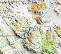
Ewasko-Bayesian-grab.jpg

The previously mentioned Adam Marsland reddit
post notes that Tom Mahood believes the body
location is "a little further south" (i.e. a little further
south of where I have overlaid the purple square).

Although the Verizon technicians assertion that the
10.6 mile distance was "90% accurate" was surely not
meant to be taken as a literal probability limit of
a lower 9.54 miles limit to an upper 11.66 miles
limit, it is interesting to see that somewhere a
little further south of that purple square is approximately
9.5 miles or so from the Verizon Serin Drive Cell
tower location.

The purple square I have marked on that 10.6
mile ping radius map, is approximately located
here on Google Maps;
Google Maps

(If Tom Mahood is correct in believing the body is
a little further south of where Adam Marslands
ended his JT90 search, then it follows the body
is currently believed to have been found a little
further south of the location I noted above in
Google maps.)

Evidently, that 10.6 mile estimation would in
fact have been a very useful rough guide to his
final body location for search purposes (and was
certainly no clerical error).
Unfortunately, for unknown reasons at present,
Bill Ewasko travelled miles away from Quail
Mountain or Johnny Lang Canyon, in a very
unexpectedly north or northwest direction. (His
itinerary destinations for that part of JTNP were
written as Quail Mountain and Johnny Lang
Canyon).
 
Last edited:
the map is based on this news report quoted above

Body Found in Joshua Tree National Park May Be Hiker Missing Since 2010

Hikers found the body on Tuesday in the park’s northwest corner, near the Panorama Loop Trail. Park rangers and deputies from the San Bernardino County Sheriff’s Department secured the scene overnight, with a crime scene investigation team arriving at daybreak on Wednesday.

...
Along with the body, investigators found a wallet with identification belonging to Bill Ewasko, a 66-year-old man from the Atlanta suburbs who went missing in June 2010, a report from local radio station KCDZ said.

...
Two days later, a California Highway Patrol helicopter located his car at the Juniper Flats trailhead, a 90-minute drive from where Ewasko had originally planned to hike.

@wary maybe some of the information in this article help understand more
 
Just a crude map, because I was curious and need a starting point -

Ignore google's suggestion of a route:

View attachment 333379

There are two trails in the park named "Panorama", and the newspaper article referred to the wrong one ("Panorama Loop"). The map above with the purple square is near the correct Panorama trail.

We still don't know exactly where Bill was found - the current guesses are based on monitoring the Sheriff Office's helicopter flight path in the park. Hopefully we will have better information in a few days.
 

Members online

Online statistics

Members online
147
Guests online
1,510
Total visitors
1,657

Forum statistics

Threads
591,780
Messages
17,958,732
Members
228,606
Latest member
wdavewong
Back
Top