Hurricane Jose September 2017

Updated 11:00am advisory:

1454075dayconenolineandwind.png


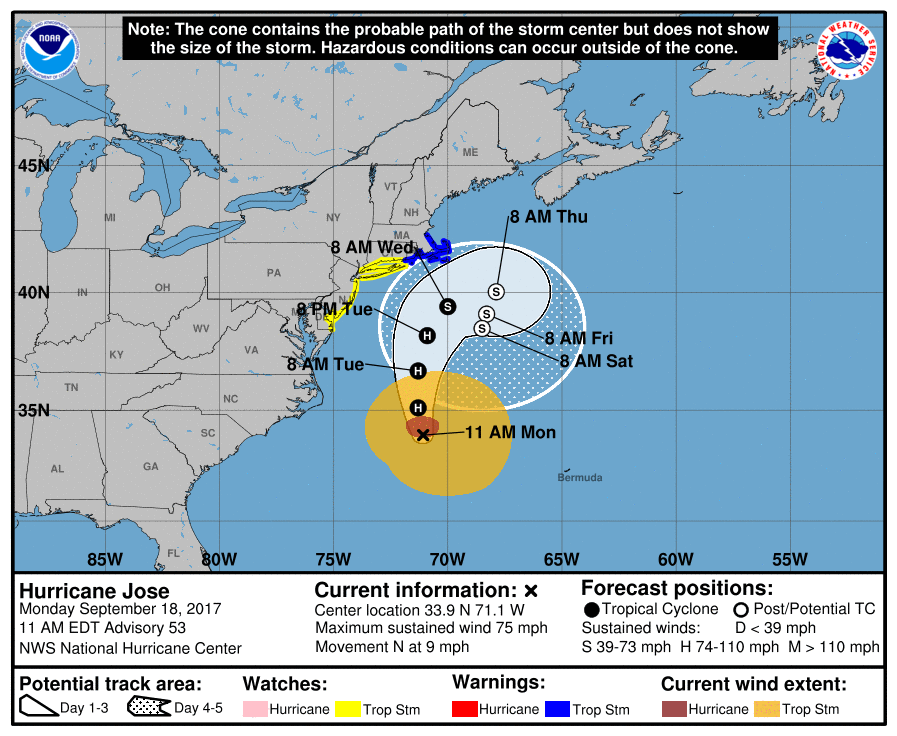
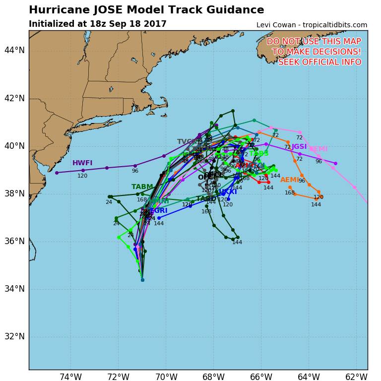
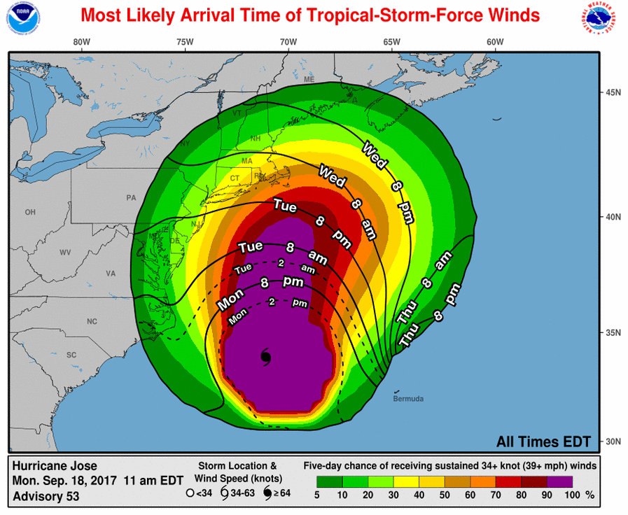
The NHC has issued a tropical storm warning for parts of New England from Watch Hill, Rhode Island, to Hull, Massachusetts, including Block Island, Martha's Vineyard, and Nantucket, as of 11 a.m. ET on Monday. Tropical storm conditions should be expected somewhere in that area within the next 24 to 36 hours.

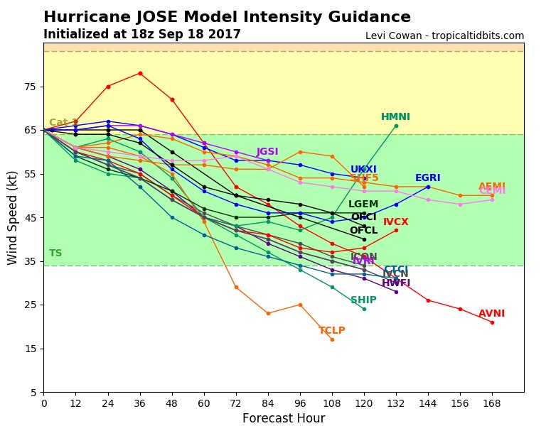
Jose's center will most likely stay out at sea, but the NHC reported that parts of the US were already feeling dangerous surf and rip currents because of the storm. Swells from Jose are also affecting the Bahamas, Bermuda, and the East Coast of the US.

Areas in the northeast under tropical storm watch run from Fenwick Island, Delaware, to Sandy Hook, New Jersey; and from East Rockaway Inlet, New York, to Watch Hill, Rhode Island. The area under the storm watch also includes Delaware Bay South.

Even if Jose stays offshore as expected, parts of the coast and Mid-Atlantic are expected to experience powerful gusts of wind, heavy rainfall with isolated flooding, and dangerous ocean conditions including coastal flooding.

145407mostlikelytoa34.png


http://www.businessinsider.com/hurricane-jose-path-update-track-east-coast-2017-9
 
On Monday morning, Hurricane Jose was about 270 miles east-southeast of Cape Hatteras, North Carolina, and was moving north at 9 mph.

"Jose is expected to produce total rain accumulations of 3 to 5 inches over eastern Long Island, southeast Connecticut, southern Rhode Island, and southeast Massachusetts, including Martha's Vineyard and Nantucket, through Wednesday," the National Hurricane Center said.

Jose is expected to weaken in the next few days, but will likely remain a hurricane through Tuesday.

http://www.cnn.com/2017/09/18/americas/atlantic-storms-maria-jose-lee/index.html
 
I've been very worried about Jose. Last I saw we should be getting about 20-25 mph winds with gusts up to 35 mph. Last night I saw someone posting surf at Point Pleasant Beach coming up to the palms over by Jenkinsons.

My house is still on jenga blocks 10 feet up in the air. No, I won't get flooding but now i'm concerned about the winds.

thanks for keeping this updated Henry!

Hi JerseyGirl-
Just got a text back from architect friend who is also Jersey Shore resident. He feels the house would be designed for that wind load during the lift. Maybe check with your builders for reassurance.

I am also in Jersey and lived through Sandy... It gave me a whole new perspective on Mother Nature, but no one knows this more than our shore peeps.

Praying Jose veers east, and season calms down so your house is completed with no issues!! Love our Jersey Shore!
 
I want to thank WS hurricane peeps for the amazing coverage, and information I never understood before. You all, Henry, CARIIS, and JerseyGirl, and so many more have been so great!!!
 
SUMMARY OF 2:00 PM EDT UPDATE

JOSE PRODUCING DANGEROUS SURF AND RIP CURRENTS ALONG THE EAST COAST OF THE UNITED STATES

LOCATION...34.2N 71.0W
ABOUT 265 MI...425 KM ESE OF CAPE HATTERAS NORTH CAROLINA
ABOUT 490 MI...790 KM S OF NANTUCKET MASSACHUSETTS
MAXIMUM SUSTAINED WINDS...75 MPH...120 KM/H
PRESENT MOVEMENT...N OR 10 DEGREES AT 9 MPH...15 KM/H
MINIMUM CENTRAL PRESSURE...977 MB...28.85 INCHES

SUMMARY OF WATCHES AND WARNINGS IN EFFECT:

A Tropical Storm Warning is in effect for...
* Watch Hill, Rhode Island to Hull, Massachusetts
* Block Island, Rhode Island
* Martha's Vineyard
* Nantucket

A Tropical Storm Watch is in effect for...
* Fenwick Island, Delaware to Sandy Hook, New Jersey
* Delaware Bay South
* East Rockaway Inlet, New York to Watch Hill, Rhode Island

48-Hour Forecast:
On the forecast track, the center of Jose is forecast to pass well offshore of the Outer Banks of North Carolina this evening, pass well east of the Delmarva peninsula tonight and Tuesday, and pass well to the east of the New Jersey coast on Wednesday.

Rainfall:
Jose is expected to produce total rain accumulations of 3 to 5 inches over eastern Long Island, southeast Connecticut, southern Rhode Island, and southeast Massachusetts, including Martha's Vineyard and Nantucket through Wednesday. Jose is also expected to produce total rain accumulations up to 2 inches along the mid-Atlantic coast, and from southeast New York to coastal Maine. This rainfall could cause isolated flooding.

http://www.nhc.noaa.gov/text/refresh/MIATCPAT2+shtml/181143.shtml
 
Yes we are, the house was raised last week and sitting on cribbing. Now they need to install about 20 or more helical piles, then lay concrete and begin building the base with concrete block.

This is not my house but cribbing looks like this. I'm worried about flooding eroding under the house as well as if the house can sustain 50 mph gusts.

We live on a canal (lagoon) a few houses in from Barnegat Bay.

1465831_623233691070032_1938903752_o-1024x668.jpg


What a beautiful house (too bad it isn;t yours ... or is yours just as lovely?). But that looks like such a long way up ... how do you get into the house after raising it like this, and what becomes of the garage ? Does it get converted to more living space? I am not fond of stairs, especially when bringing home groceries. Hubby always wanted to raise our old "foundation-less" home (1875 or so), but now I can see how much work that entails and why it costs so much.


I want to thank WS hurricane peeps for the amazing coverage, and information I never understood before. You all, Henry, CARIIS, and JerseyGirl, and so many more have been so great!!!

I second that! I have learned a lot from these weather threads lately.... and met lots more wonderful members/.
 
NHC 8:00 Update:

The eye wall continues to be exposed, re-tensificatipn is not expected.

DISCUSSION AND 48-HOUR OUTLOOK ------------------------------ At 800 PM EDT (0000 UTC), the center of Hurricane Jose was located near latitude 34.8 North, longitude 71.5 West. Jose has been nearly stationary during the past few hours, but it should resume a motion toward the north near 10 mph (17 km/h) later tonight or Tuesday. A turn to the northeast is expected to occur on Tuesday night. On the forecast track, the center of Jose is forecast to pass well offshore of the Delmarva peninsula early Tuesday, and pass well to the east of the New Jersey coast on Wednesday. Maximum sustained winds remain near 75 mph (120 km/h) with higher gusts. Little change in strength is forecast during the next 48 hours. Hurricane-force winds extend outward up to 60 miles (95 km) from the center and tropical-storm-force winds extend outward up to 230 miles (370 km). The minimum central pressure recently reported by an Air Force Reconnaissance plane was 973 mb (28.73 inches)

http://www.nhc.noaa.gov/text/refresh/MIATCPAT2+shtml/151452.shtml?

http://spaghettimodels.com
c418f13939263aae3a7675d55eefd87c.jpg
fc94bdf69cf29b0cfee3e9c9a4048783.jpg
10d54ef7dea76ccb8f5ecec4a2c2fdcf.jpg
1279fddca0f473b5daf0cf5eb4d1c398.jpg


Sent from my VK815 using Tapatalk
 
The winds were whipping early Tuesday as the Jersey shore and Long Island began to feel increased effects, and it is possible there could be moderately significant flooding and beach erosion with the coming high tides.

The storm is unlikely to make landfall, but Jose's center was about 395 miles south of Nantucket, Massachusetts, early Tuesday and moving north at 8 mph with maximum sustained winds of 75 mph.

Eastern Long Island is expected to be the hardest hit in our area, and crews are gearing up for heavy rain and wind. Dix Hills is serving as the base for emergency operations.

Wave heights are expected to top out between 10 and 15 feet, with the strongest winds over eastern Long Island gusting up to 50 mph. Farther west, including the New York City area, winds can gust over 30 mph at times late Tuesday into early Wednesday.

090808_5day_cone_no_line_and_wind.png


http://abc7ny.com/weather/hurricane-jose-stirs-up-rip-currents-rough-surf-along-li-nj/2419190/
 
"Jose slowly losing steam. TS Watches/Warnings up for the NE. Expected to run into a high and bounce back south. The story of his life. He likes to go in circles.*www.spaghettimodels.com*/ Mikes Weather Page APP"
db1c12c98c306c99b83193608636f3c6.jpg


Sent from my VK815 using Tapatalk
 
CONNECTICUT, NEW JERSEY, NEW YORK:

Tropical Storm Watch in effect until 4:00 PM EDT for Eastern Long Island and Southeast Connecticut

Tropical Cyclone Statement in effect until 1:30 PM EDT. This covers Southeast New York, Northeast New Jersey, and Southern Connecticut.

Connecticut:
A Tropical Storm Watch is in effect for Northeastern Suffolk, Northern Middlesex, Northern New London, Northwestern Suffolk, Southeastern Suffolk, Southern Middlesex, Southern New Haven, Southern New London, and Southwestern Suffolk.

Eastern Long Island and Southeast Connecticut:
Hurricane Jose will continue to track northward through the western Atlantic waters through mid week, passing to the southeast of the area late tonight into Wednesday as a tropical storm. The system looks to be close enough for potential impacts, including tropical storm force winds, coastal flooding, and locally heavy rainfall. The best chance for tropical storm force winds and heavy rain will be across eastern Long Island and southeast Connecticut. Minor to moderate coastal flooding is also likely along with dangerous surf.

Prepare for dangerous surf of 10 to 15 ft causing widespread dune erosion, and localized dune overwashes along the Atlantic beachfront.

http://www.norwichbulletin.com/section?template=weather_alert
 
New Jersey, New York, Connecticut

Middletown, NJ
Police say they rescued a driver from the area of Broadway and Main Street Tuesday morning when he tried to drive through high water. His car ended up leaving the road and into a ditch,

Manasquan NJ:
Manasquan Borough @ManasquanOEM
Minor coastal flooding is occurring with this morning's high tide. Moderate flooding expected tonight. High tide 8 p.m.
8:41 AM - Sep 19, 2017

Manasquan officials also said some streets had minor flooding from the morning's high tide.

Belmar NJ:
Brian Thompson ✔ @brian4NY
BREAKING EXCLUSIVE: Belmar fishing pier damaged by #Jose credit: @mattdohertynj I'm live at 11am @NBCNewYork @JSHurricaneNews @belmardays
9:08 AM - Sep 19, 2017 · Monmouth Beach, NJ
In Belmar, waves lashed at the shore so fiercely they damaged a fishing pier that had been restored from Sandy damage in a half-million dollar project.

Police in communities along the shore said the storm was causing dangerous conditions in the water and reminded people not to go in.

Hurricane Jose is expected to stay out to sea but will still deliver punishing rains, rough surf, wind and beach erosion to the tri-state area.

Long Island, Connecticut, Rhode Island
A tropical storm watch is in effect for the coast of Long Island from Fire Island inlet to Port Jefferson, and from New Haven, Connecticut, to Watch Hill, Rhode Island.

Brooklyn, Queens, Staten Island, Northern New Jersey
A coastal flood watch escalated to a warning for parts of Brooklyn, Queens, Staten Island and northern New Jersey from Tuesday evening to Wednesday afternoon. The coastal areas are expected to get the brunt of Jose's conditions.

http://www.nbcnewyork.com/news/loca...re-Long-Island-Tri-State-Coast-445723563.html

The following advisories are in place for the area:

Coastal flood advisory in effect in parts of Brooklyn, southern Queens, southern Nassau County, Long Island Sound shores and southwestern Connecticut on Tuesday

Coastal flood warning for south shore bays of NYC and Nassau County, as well as coastal areas of New Jersey and Delaware, and areas along Delaware Bay Tuesday evening into Wednesday morning

High surf advisory through 6 p.m. Wednesday in Brooklyn, southern Queens and southern Nassau County

Tropical storm watch Suffolk County on Long Island, and Middlesex, New Haven, and New London Counties in Connecticut.

Tropical storm warning issued south of Long Island, between Montauk Point, NY and Sandy Hook, NJ

http://pix11.com/2017/09/19/hurrica...ross-ny-nj-greatest-impacts-to-be-felt-on-li/
 
Jose jogged just a tic East to lessen the burden on the North. Atlantic. It is barely hanging on to Hurricane status. The eye is no longer visible with wall completely collapsed. Hurrah!!
Waves are increasingly high with significant riptides.
Jose is expected to circle back around and play a role into taking Maria out to sea.....Hoping....
2a466e0b0141bfe78a4002e9944dc13e.jpg
b7ed0bca620caef77b5904accbcd239b.jpg
722c5147799848e397b4eb22728ce5aa.gif
e6b050084511d7f68ed95018ebb55a19.jpg
31fbc3bbd445917a2a1a578ce203d20a.jpg


Sent from my VK815 using Tapatalk
http://spaghettimodels.com
 
Jersey- hoping for you, no damage. Let us know.

Sent from my VK815 using Tapatalk
 

Members online

Online statistics

Members online
172
Guests online
4,424
Total visitors
4,596

Forum statistics

Threads
591,842
Messages
17,959,889
Members
228,622
Latest member
crimedeepdives23
Back
Top