Hi Nova, good question. My understanding is based on what I posted in the first post in this thread. I'll repost below. Note the bold.
http://www.weatherzone.com.au/help/article.jsp?id=71
Thing is we have been hit by cyclones from almost all directions (except below which is Antarctica, so when we get blasted from there it generally brings great snow to our ski resorts and miserable rain everywhere else :laugh: (I'm a skier ... obviously!). Bet none of you realised we have snow in surf-beach-loving-Australia!
In the past 2 weeks we've had cyclones hit Perth, Western Australia (which then had bushfires a week alter), plus 2 cyclones that hit the northern Queensland area. You can see the small first cyclone that preceded Yasi in the animation in my first post of this thread. It was pretty mild, though it combined with Yasi to cause all the flooding down the east coast of the continent. To put it in perspective, if you look at the maps of the USA and Australia superimposed posted earlier, Yasi affected the entire country ... so if she had hit the US she would have affected the entire country too!. This was just MASSIVE! Lucky we only have about 23 million people in the entire country!
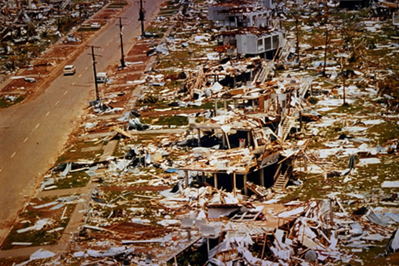
Australia learned the hard way about dealing with nature's fierce temper. In 1974 on Christmas eve, our northern-most capital, Darwin (Northern Territory) was hit by Cyclone Tracy. Tracy formed over the the Arafura Sea, thn moved southwards to Darwin. 80% of houses were flattened and over 70% of buildings were destroyed. More than 41,000 out of the 47,000 inhabitants of Darwin were left homeless. 71 people died. Darwin looked like this:
And in true form this was the attitude:
Crazy Aussies! Always smiling!
So after the devastation of an entire capital city, Australia learned that we needed to design buildings, especially houses in a fashion that could withstand not only the grueling heat and rain, but also cyclones. New building regulations were drafted.
Northern Qld and Northern Territory are north of the Tropic of Capricorn - ie they're humid, tropical belts with enormous flooding rains in the summer wet season. For this reason, houses are raised on platforms and stilts to allow the heat to flow underneath the floor, and have large verandahs to provide shade. In Qld these houses are spectacularly beautiful, and are called "Queenslanders":
New houses have strong foundations and supports. In the NT the underneath is usually filled in with besa bricks, but still with sections open to allow for the breeze.
In my opinion, the improvements in construction have made all the difference this time around. Yasi was enormous - like a bunch of Tracys in a cluster with their arms linked, and yet she didn't have anywhere near the impact. It is such a relief!
I really appreciate (on behalf of my fellow Aussies) how you guys are so supportive through this. It's been a crazy couple of weeks I have to tell you! Glad you like the pics
")