OK OK - Molly Miller, 17, & Colt Haynes, 21, Wilson, 7 July 2013 - #1

Status
Not open for further replies.
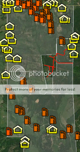
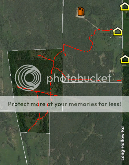
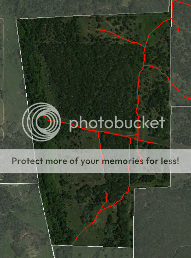
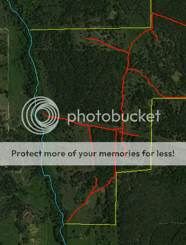
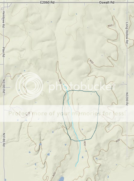
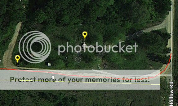
That does look like a wicked tight spot. If that's the place and there's no livestock in that pasture, the landowner may not have noticed he had a fence down before they pulled the car out of there.

Hey, does anyone know anything about shock? Could Colt have gone into shock from his injuries? I know nothing about it so, if it happened to someone right in front of me, I wouldn't have any idea what was wrong. Did a little googling and it looks like symptoms include confusion and agitation, and his sister mentioned in the interview that Colt seemed agitated and disoriented when he was on the phone with friends. Maybe only due to being lost in the dark, but could it have been something more?

I'm not a medical professional, but I'm certain...if the bone was sticking out, absolutely. I've watched someone go into a shock after a car accident and have experienced it myself after one (I can't speak much about the latter because I honestly don't remember) -- and neither of those were injury accidents.
 
If you use the search box and the right keywords, it's still possible to unearth some interesting tidbits on OFMM. In the earliest posts, the family was giving many more details than they are now. This one's about the fiery hole:

https://www.facebook.com/groups/438762539575189/permalink/439903702794406/

There's a timeline of the fire down in the comments, when it started and the activity that ensued over the next two weeks. Says the hole was in a field not far from where the car was found.
 
Great efforts. Its probably pretty darn close to somewhere along those lines.

I began thinking they most likely would have wrecked around a really sharp bend, but if the roads were really rutted out and generally bad dirt roads, then they could have lost it even in the straighter portions.

They were probably traveling too fast for the road conditions, so unfortunately, just the bendy parts are not the only parts they could have lost control.

I took a look at Google maps of this area to see the dirt roads running off Long Hollow. In your second picture, there is a wavy line (dirt road) in the right hand corner (outside of the area you highlighted), which looks like a possibility too. There is a sharp turn were the road suddenly goes south and it occurs where the land is cleared of a lot of trees. There looks like a fence line along that clearing (pasture?). I also don't see a gate on the Long Hollow end, so it makes me think this road was accessible. Oops! I should have posted this comment for okiegranny. I'll repost.
 
Regarding the maps, just want to thank you Okiegranny for building and showing the maps of the area and the most logical places where we think things unfolded. It is so nice to have a picture of the area we are talking about.

Only wish there was some way to definitely pinpoint some critical points like CN's house, the car wreck, etc. I am curious how far his house was from the car wreck.
Without getting more information, I realize its very hard to pinpoint exactly where these types of things are. You did a wonderful job getting us very close I believe.
 
Tried a process of elimination to see if that would be more helpful in pinning down the location of the wreck, based on the Millers' descriptions of the day the car was found and physical characteristics of the land itself and the surrounding properties.

Most of the shaded areas are properties that have a clear fenceline with no road passing through, and other properties without a clearly visible fence but inaccessible from Long Hollow without crossing either the creek or another property's fence. The only two places I can see to drive across the creek that runs down the middle are both located on fenced-in private property. Cannot find any other roads that cross it, so that's my western cut-off line. Other shaded properties were eliminated by the Millers' description of their location on the day of the search.

Overview of the entire area to get your bearings. Pike on the left, Long Hollow on the right, Oswalt across the top:

Screenshot2013-11-04at11943PM_zps6505ed8f.png


Zooming in on the unshaded area that could not be ruled out, with Long Hollow on the right, the creek on the left, and red lines tracing the dirt roads:

Screenshot2013-11-04at11900PM_zpsf2b7d359.png


And then zooming in closer on the area I could not reasonably eliminate:

Screenshot2013-11-04at105553AM_zps6de5b993.png


So there. I think it's most likely the wreck happened somewhere in there. And I think Colt and Molly headed west, maybe northwest or southwest, but westward from there. Don't know what the driver did, either ran to his house nearby or stayed with them for some period of time, but I don't think Colt and Molly would have wanted to go back in the direction where LE might be coming.

I don't know how deep or wide the creek is, but they would've had to get across it, through it, or around it for Molly to be on Pike Road at 9:33 a.m. Maybe crossing the creek is where Colt broke his ankle?

I messed up, I should have posted my comment on the dirt roads under your original post, so here it is again:

I took a look at Google maps of this area to see the dirt roads running off Long Hollow. In your second picture, there is a wavy line (dirt road) in the right hand corner (outside of the area you highlighted), which looks like a possibility too. There is a sharp turn were the road suddenly goes south and it occurs where the land is cleared of a lot of trees. There looks like a fence line along that clearing (pasture?). I also don't see a gate on the Long Hollow end, so it makes me think this road was accessible.
 
If you use the search box and the right keywords, it's still possible to unearth some interesting tidbits on OFMM. In the earliest posts, the family was giving many more details than they are now. This one's about the fiery hole:

https://www.facebook.com/groups/438762539575189/permalink/439903702794406/

There's a timeline of the fire down in the comments, when it started and the activity that ensued over the next two weeks. Says the hole was in a field not far from where the car was found.

Good stuff, thanks! Why would anyone bother to get rid of a huge stump, unless they were going to farm the area or build something on that spot?
 
Regarding the maps, just want to thank you Okiegranny for building and showing the maps of the area and the most logical places where we think things unfolded. It is so nice to have a picture of the area we are talking about.

Only wish there was some way to definitely pinpoint some critical points like CN's house, the car wreck, etc. I am curious how far his house was from the car wreck.
Without getting more information, I realize its very hard to pinpoint exactly where these types of things are. You did a wonderful job getting us very close I believe.

It just seems like we need a starting point, you know? That area is huge and they could be anywhere in the two miles between Pike and Long Hollow. So a starting point where they exited the car at least narrows it down a little, so we can study the topography and make reasonable guesstimates on where they might be now, if they're not in the hole.

I do know which house it is, but cannot point it out on here unless he is charged in the case or officially named a POI. It is close by.
 
I'm not a medical professional, but I'm certain...if the bone was sticking out, absolutely. I've watched someone go into a shock after a car accident and have experienced it myself after one (I can't speak much about the latter because I honestly don't remember) -- and neither of those were injury accidents.

I've broken quite a few bones over the years (arm, leg, hand, finger . . ). Fortunately, all of them didn't break the skin, but both my broken leg and arm (dislocated shoulder too) poked my skin out. In other words, the broken bone had stretched the inside out, so it looked like a big lump. There was no break in the skin. So, I'm thinking there is a possibility Colt only had the lump sticking out —not that bone broke through skin.

I hope I worded this so it makes sense . .
 
It just seems like we need a starting point, you know? That area is huge and they could be anywhere in the two miles between Pike and Long Hollow. So a starting point where they exited the car at least narrows it down a little, so we can study the topography and make reasonable guesstimates on where they might be now, if they're not in the hole.

I do know which house it is, but cannot point it out on here unless he is charged in the case or officially named a POI. It is close by.

ok...so we agree then that he could have walked home from the car wreck area. That was the main thing I was curious about if he could walk it. It sounds like that is how he got home then.

Its obvious from the alleged phone calls from the other 2 that they were basically lost.
 
I messed up, I should have posted my comment on the dirt roads under your original post, so here it is again:

I took a look at Google maps of this area to see the dirt roads running off Long Hollow. In your second picture, there is a wavy line (dirt road) in the right hand corner (outside of the area you highlighted), which looks like a possibility too. There is a sharp turn were the road suddenly goes south and it occurs where the land is cleared of a lot of trees. There looks like a fence line along that clearing (pasture?). I also don't see a gate on the Long Hollow end, so it makes me think this road was accessible.

yeah, I think you are referring to the same wicked left turn we were talking about a few posts ago. Post 508+509 It is more than a 90 degree turn. Its more like a 110 degree left which is wicked. And before the turn, he may have been going really fast because the road is straight before that turn.
 
I took a look at Google maps of this area to see the dirt roads running off Long Hollow. In your second picture, there is a wavy line (dirt road) in the right hand corner (outside of the area you highlighted), which looks like a possibility too. There is a sharp turn were the road suddenly goes south and it occurs where the land is cleared of a lot of trees. There looks like a fence line along that clearing (pasture?). I also don't see a gate on the Long Hollow end, so it makes me think this road was accessible.

If we're talking about the same road, that's the one highlighted on my previous map, showing how it goes all the way across and comes out on Pike Road. I had reservations about including that one on the current map for a few reasons. It cuts across the ranch, so there's probably a locked gate at some point before a car can go very far along there and I couldn't figure how the driver would have planned to get through. There's a heavily wooded area and a definite fenceline separating that road from the unshaded area with no visible path between them. And the distance estimate by family members between their location and where the car was found seems to put that road a little too far out of range.

It's still a possibility, but it just doesn't seem to fit the info we have to work with.
 
The blue line on the left marks the location of the creek and the yellow lines are visible fencelines surrounding our target area. This leaves an open space on the upper right, but whatever fences exist there seem to be hidden further back in the trees:

Screenshot2013-11-05at125200PM_zps95e7734e.png


Here's the terrain map again to help us understand what Colt and Molly would've had to navigate if they tried to walk out of the area. I drew a blue line to represent the creek, which runs through a valley between two higher ridges, and a black line around the location of our target area:

Screenshot2013-11-05at23729PM_zps1fcab31d.png


So anyone heading east or west from the creek would have to go uphill and then downhill to reach a road. Cannot say how steep the grades on those ridges would be.

Just FYI, to give you a sense of scale, the large pond at the bottom edge of the terrain map is 2.75 miles south of Oswalt Road, and about 3,700 feet south-southwest of the point where the southernmost fence in our target area meets the creek.
 
Again, a great job with the maps. This really helps us to get a visual on what they were dealing with.
 
Found weather data for the area; Marietta is the closest reporting station, less than 20 miles away. Here's the daily high and low temps for the entire week beginning Sunday, July 7:

Sun, Jul 7.....94/70

Mon, Jul 8.....91/72

Tues, Jul 9....95/72

Wed, Jul 10...98/74

Thu, Jul 11..100/73

Fri, Jul 12....103/71

Sat, Jul 13.....98/71

No precipitation fell during the week.

OMG! They needed water! It was probably a dry heat and they had access to shade, but they needed water. Dehydration comes to mind. At the very least, it was very uncomfortable for them.
 
The blue line on the left marks the location of the creek and the yellow lines are visible fencelines surrounding our target area. This leaves an open space on the upper right, but whatever fences exist there seem to be hidden further back in the trees:

Screenshot2013-11-05at125200PM_zps95e7734e.png


Here's the terrain map again to help us understand what Colt and Molly would've had to navigate if they tried to walk out of the area. I drew a blue line to represent the creek, which runs through a valley between two higher ridges, and a black line around the location of our target area:

Screenshot2013-11-05at23729PM_zps1fcab31d.png


So anyone heading east or west from the creek would have to go uphill and then downhill to reach a road. Cannot say how steep the grades on those ridges would be.

Just FYI, to give you a sense of scale, the large pond at the bottom edge of the terrain map is 2.75 miles south of Oswalt Road, and about 3,700 feet south-southwest of the point where the southernmost fence in our target area meets the creek.

Great work on the maps! Do you have any idea who owns this land? Addison Ranch? Nipp family?
 
Holy cow, you guys! What was I just saying earlier? The right keywords will dig up some gems! I have never seen this bit of info before:

https://www.facebook.com/groups/438762539575189/permalink/441759155942194/

Travel trailer, circle drive, gate beyond.

Looky here:

Screenshot2013-11-05at64347PM_zps784946a8.png


Here's what that place looked like in 2008:

Screenshot2013-11-05at64429PM_zpsa6bc8bfe.png


This is the second road that turns off Long Hollow, the southernmost one. In 2008, there was a mobile home at that corner, which appears to have burned to the ground. As of April 17, 2012, when the first satellite image is dated, it looks like only the porch and walkway remained. However, the utilities would still be in place so it would be totally feasible to pull in a travel trailer, hook up the water and electric and, voila! Home sweet home.

There's a shadow on the road just below the yellow balloon on the left. The road turning north just beyond it leads to what looks like a salvage yard and I thought that sort of business would probably have a gate; that shadow across the road was the only thing I could find that looked like a possibility. Or it could also be a utility pole.

Now I'm pretty sure that shadow is a gate and this is the road where the car turned off of Long Hollow that night.
 
Great work on the maps! Do you have any idea who owns this land?

Honestly, I do not. Seems to be kind of a no man's land outside of any property's fences. Could belong to any of the surrounding landowners, I guess.
 
Status
Not open for further replies.

Members online

Online statistics

Members online
165
Guests online
3,582
Total visitors
3,747

Forum statistics

Threads
592,296
Messages
17,966,877
Members
228,735
Latest member
dil2288
Back
Top