Found Deceased Spain - Esther Dingley, from UK, missing in the Pyrenees, November 2020 #5

Status
Not open for further replies.
Yes, I strongly doubt any hiking possible east of Port de la Glère. On the west side, however, there is a path to a summit, clearly more technical than the broad paths between valleys and passes. It might be natural after reaching Port de la Glère to try to go a bit higher for a view ; a fall in this area could explain bones left at the pass. It does not explain "no phone contact" though : as long as you are on the ridge, directly over the Hospital de Benasque valley, you certainly get optimal network access.

On this page, a hiker left loads of pictures of an outing at Pic de Sacroux, including a vulture circling and waiting for a lunch opportunity...
 
The Port de la Glere was part of her planned route, so it would have been searched on the first day, by helicopter to start with.

I find it hard to believe that Esther would have gone from the top of the Salvagurdia to the Port de la Glère after telling Dan of her plans and with so little daylight remaining. There is no path that I know of, it is one-way up and down.
IMO, not sure that Patrick Lagleize meant to say that she did take the west route instead of going to the Refuge de Venasque for the night as planned. Still, his remarks about 'the logic of their progress' are very interesting.
I do remember from an earlier hike that she posted of FB that she had trouble keeping the right track going up to another mountain top, but she got there. ;)

Dan apparently does not believe this west route either, since the line Sauvegarde - Port de la Glere is more or less the one track he did not hike, except for the part in the middle.
He obviously looked for Esther in the area where she may have had a good network connection but did not make a call.

_119382287_9f79a52d-7cd9-43ff-b437-fc9b6d728c75.jpg


Esther Dingley: Partner vows to keep searching for missing hiker

I notice DC's red lines show him going through the P de la G only once. IMO he would have had to match ED's direction of travel to have any chance at seeing remains.
Personally, I think the odds DC was ever going to see remains were very slight. How you search is an art and a skill. This is one of the several reasons SAR does not like members of the random public (even accomplished hikers, but especially family) to get involved in the searching at all. When sanctioned searches go out, they happen under the auspices of SAR with very strict protocols. Often, volunteers are used for grid searches where folks stand just a few feet apart, but they are heavily supervised; a trail search takes very specific training.
IMO we have to trust LE/SAR, especially in this case, when it comes to what was searched, how it was searched, the odds of finding a missing person—in fact, anything at all to do with searching in this case. It is their terrain, they are the ones with experience, they are methodical, and they have very specific ways to get the ground covered. They explicitly didn't call on volunteers; indeed, they went so far as to bring in national guard members.
For me, I won't trust any other contribution to the "this area was searched" bin. For me, LE/SAR protocol and assessment only; they don't trust anyone else's role, either.
 
SBM BBM

Yes, this route makes total sense to me and explains why there was not only no phone contact, but also no signal from her phone after 4pm on 22nd. I cannot imagine that ED would not have turned on her phone at some point the next day if she had gone to Port de la Glere via the Spanish side. It also explains the lack of FB posts on the 22nd (when she had been posting every day in the days leading up to that day).
There was no cell phone service there. We can surmise that because there was no cell service at the Cabane in the valley on the Spanish side. By contrast, there IS cell service in the area of Venasque and Hospice. It's very unlikely there was cell service in the P de la G.
 
When I look at that map, and know that within days of her disappearance Dan was leaning towards criminal event, I wonder whether he is looking for bones, or demonstrating that he has hiked far and wide and did not see her - therefore she was abducted.
Yes, that would be like looking at the event through the wrong end of a telescope, i.e. with a preconceived assumption. SAR would want to be demonstrating the opposite, i.e. with no assumptions but a guess about where an accident might take place, both because of their familiarity with the terrain and because "people have accidents in that spot all the time."
 
Yes, I strongly doubt any hiking possible east of Port de la Glère. On the west side, however, there is a path to a summit, clearly more technical than the broad paths between valleys and passes. It might be natural after reaching Port de la Glère to try to go a bit higher for a view ; a fall in this area could explain bones left at the pass. It does not explain "no phone contact" though : as long as you are on the ridge, directly over the Hospital de Benasque valley, you certainly get optimal network access.

On this page, a hiker left loads of pictures of an outing at Pic de Sacroux, including a vulture circling and waiting for a lunch opportunity...
Except on the Pic, ED would never have been on a ridge if she went the P de la G route. There would always have been rocks or mountains looming overhead. Not just her cell, but her GPS would have been useless.
I wonder if she tried to use her cell on that near vertical slope and that's how she got into an accident. It wouldn't have worked there (the slope is in a niche), but she might have tried.
 
On this page, a hiker left loads of pictures of an outing at Pic de Sacroux, including a vulture circling and waiting for a lunch opportunity...
Snipped for focus

I'm bumping this for the photos. This is what the area of the P de la G is like. Consider trying to go DOWN this in bad weather. We know it was below freezing at night.
 
It's very unlikely there was cell service in the P de la G.

I don't think so. Port de la Glère is immediately above Plan de l'Hospital, with a hotel, a small nordic ski resort and a gigantic parking lot. I know there is excellent phone coverage at Plan de l'Hospital (I was there less than one month ago ;-)), though not further east at Besurta hut. It seems to me highly likely that this coverage extends to the Glère pass above.

Of course, we cannot deduce much from the silent phone. Maybe ED intended to leave airplane mode only in the afternoon and met her destiny before...

Capture d’écran de 2021-07-28 21-06-04.png
 
Last edited:
IMO, not sure that Patrick Lagleize meant to say that she did take the west route instead of going to the Refuge de Venasque for the night as planned. Still, his remarks about 'the logic of their progress' are very interesting.
Snipped for focus.
Lagleize is experienced SAR. IMO he knows exactly what he's talking about, so I'm not sure we should second guess.
 
I don't think so. Port de la Glère is immediately above Plan de l'Hospital, with a hotel, a small nordic ski resort and a gigangic parking lot. I know there is excellent phone coverage at Plan de l'Hospital (I was there less than one month ago ;-)), though not further east at Besurta hut. It seems to me highly likely that this coverage extends to the Glère pass above.

Of course, we cannot deduce much from the silent phone. Maybe ED intended to leave airplane mode only in the afternoon and met her destiny before...

View attachment 306313
It is my understanding, too, that there must be cell service at the Hôpital, and there are many commercial reasons for having service there. And we do know the whole valley isn't covered. For instance, there's no coverage to the Cabane, which is just up the way.
Heading up to the P de la G, per the contoured map, there are mountain spurs, a big dip for a lake, ups and downs, and then a deep notch at the P de la G itself. In my experience, you don't get cell service in mountainous ups and downs, or with narrowed windows for reception (e.g. in a notch or nook). This is actually quite a problem for SAR, because people in the most likely places to have accidents can't get signals.
I suppose we could find out for sure if there'd be a signal at P de la G, but I doubt it.
 
Snipped for focus.
Lagleize is experienced SAR. IMO he knows exactly what he's talking about, so I'm not sure we should second guess.

I am not second-guessing Patrick Lagleize, what makes you think that I do?

This is what he says in the interview:

She may have wanted to go that way when she saw the path from the Port du Vénasque... She may have crossed by the ridges, it's difficult to say, or she may have taken the wrong path...

Spain - Esther Dingley, from UK, missing in the Pyrenees, November 2020 #5

IMO Patrick Lagleize mentions various options, one of them being that ED may have crossed by the ridges. He is not saying that she did.

I'm with you on this, IMO he was saying it was a possibility that she had considered that route and may have attempted it, nothing more.
 
I am not second-guessing Patrick Lagleize, what makes you think that I do?

This is what he says in the interview:

She may have wanted to go that way when she saw the path from the Port du Vénasque... She may have crossed by the ridges, it's difficult to say, or she may have taken the wrong path...

Spain - Esther Dingley, from UK, missing in the Pyrenees, November 2020 #5

IMO Patrick Lagleize mentions various options, one of them being that ED may have crossed by the ridges. He is not saying that she did.
We are on the same page. I can see maybe I read one of your sentences not the way you intended.
 
It is my understanding, too, that there must be cell service at the Hôpital, and there are many commercial reasons for having service there. And we do know the whole valley isn't covered. For instance, there's no coverage to the Cabane, which is just up the way.
Heading up to the P de la G, per the contoured map, there are mountain spurs, a big dip for a lake, ups and downs, and then a deep notch at the P de la G itself. In my experience, you don't get cell service in mountainous ups and downs, or with narrowed windows for reception (e.g. in a notch or nook). This is actually quite a problem for SAR, because people in the most likely places to have accidents can't get signals.
I suppose we could find out for sure if there'd be a signal at P de la G, but I doubt it.

Cell coverage is very much line of sight - I have this issue at our place in the country. In bad, damp weather the thick tree cover disrupts the signal too much, and i have to walk down the road 150m to a farmers field where I have a clear view to the cell tower about 1km away over the fields instead of through the forest

Large rock formations obviously don't allow signal to pass through them
 
Not exactly. There is another path linking refuge de Vénasque (east of the map) and Port de la Glère (west). It goes over a pass south of Pic de Sajus, then along a lake (Lac de la Montagnette), then downhill inside cirque de la Glère where it meets the much more trampled classical path from the Pique valley (the road downhill).

This is obviously a harder path than the detour through Hospice de France, but it is nonetheless plain hiking, not alpinism. It is traced on Openstreet map, hence is not a secret (though it is not waymarked). If she slept Saturday evening at Refuge de Vénasque (very likely for me) and chose this road, it might help to explain why there was absolutely no phone contact on Sunday : unlike the descent to Hospice de France, these secondary valleys are unlikely to have mobile phone access.

View attachment 306294
Yes, yes, @Pyrenean passer-by. And welcome to WS. That route has been examined by some of us here since Dec. / Jan... not a popular discussion because data was not necessarily pointing to this option for ED's route. But now, naturally as different views on old data and new data have emerged, this route option may need closer consideration. I think it was @otto and I who played with mapping that route way back. And I mentioned it as my "short cut" option just up thread when thinking about how ED could have attempted to trek to P de la Glere. It does look difficult and there are several lakes... back to the possibility lakes play a role here. Have you hiked in that area? Any more insights on possible spots where ED's remains and stuff could be hidden?
 
Last edited:
Hmm, some interesting discussions going on, not much to add, except a thought about ED’s cell/mobile.

Not sure where I read it, but I understood that ED used to turn her phone off to conserve the battery while hiking: cold air can deplete batteries quickly, and in poor reception areas phones use more energy to try and maintain connections. Ever notice how your smartphone may last a full day in an urban area with lots of towers, but go to the countryside with iffy reception and the batt will be much more discharged by evening-even with less use.

As I see it, ED possibly just turned on the phone when actually needed, so she’d potentially finish her last communication, pack the phone in her pocket or backpack, so it’s not lost, then move on to her next stop.

If madam mischief caused her to slip and fall, she could have either been too disabled to get to her phone, dead, or possibly unconscious until the cold weakened or killed her overnight!

This disappearance really hit me, I remember first reading of her and DC in a magazine article last year, and felt quite envious of their lifestyle…so followed their journey on and off until she disappeared…really tragic.
Yes, on the phone getting out of reach by accident.
Also....
If the phone died, she actually did have a battery charger, but nowhere is it convenient to do a recharge when you're in the backcountry and you can't stop for some reason, e.g. terrain, weather, shelter, etc., and it would have needed several hours for a full charge.
Plus, the backup battery could have died.
The backup and the phone would have had to be kept on the person under a jacket or something to keep them from dying in those conditions. It went below freezing those nights, and gosh knows how cold it might have become in those shadowy spaces.
If they were in the pack, either battery (plus the batteries in the Bindis) might have simply died, with no backup. IIRC ED wasn't carrying anything with regular disposable batteries, which aren't so finicky.
 
Last edited:
Disparition d’Esther Dingley : "Il faut aussi de la chance pour retrouver la personne"

Disappearance of Esther Dingley: "You need some luck to find the person"

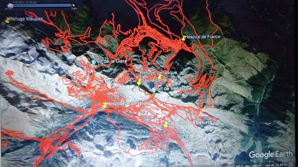
Patrick Lagleize, a young retiree and president of the Luchon mountain office and president of the Compagnie des Guides des Pyrénées, spent his entire career in the high mountain police squad, the PGHM. He knows the Port de la Glère well. He carried out several interventions there during his career as a rescuer, even if today he doesn't frequent it much.

Is this the end of the story of this disappearance?

We have to be careful and wait for the results of the DNA analysis. Having said that, I would like to point out, as a former rescuer, that in France we have the best mountain rescuers. The people of Luchon have invested a lot in the search since the announcement of Esther's disappearance last November. When there is a disappearance in the mountains and the victim is not found, it is because we have not been able to find a coherent route. You also have to rely on luck to find the person, often several months or even years later. For Esther, the area was inspected many times.

Does the location seem logical in relation to her itinerary?

The Port de la Glère was probably the gateway for her to return to Spain. A "Port" in the Pyrenees is a passage. She may have wanted to go that way when she saw the path from the Port du Vénasque... She may have crossed by the ridges, it's difficult to say, or she may have taken the wrong path... But what I notice is that we can't find the victims in the mountains if we don't understand the logic of their progress. I am thinking of the disappearance of Gatien Loison. The guy was a seasoned hiker, a real strong man, but he didn't practice mountaineering. He fell while trying to go climbing. There was no logic to it. Hence the difficulty in finding him. Afterwards, unfortunately, you have to rely on luck. For Gatien, this happened to be a hiker who got lost, found some bones and raised the alert. In this case, I think it was animals that transported the remains, which we think were human. But in my opinion, Esther didn't fall very far from there.

Do you know the place?

Yes, I did some rescues there when I was with the PGHM. Once, we had to recover people who had got lost. They were stuck on a rocky bar. If they had moved a few centimetres, it would have been very serious. We were also called to another person who had fallen. There, the outcome was much less favourable. The port de la Glère, at an altitude of around 2,200 metres, is a well-known place for hikers. You can lose your way and slip on the loose scree. I don't go there too much these days because I tend to climb with my clients and it's not a place for that. That Esther fell down there, according to logic, is unfortunately quite plausible.

BBM

This article gives insight into how SAR have approached the search, and what they encounter when someone is missing. What stands out for me is this:
  • "When there is a disappearance in the mountains and the victim is not found, it is because we have not been able to find a coherent route.
  • But what I notice is that we can't find the victims in the mountains if we don't understand the logic of their progress.
  • I think it was animals that transported the remains, which we think were human. But in my opinion, Esther didn't fall very far from there.
  • The port de la Glère, at an altitude of around 2,200 metres, is a well-known place for hikers. You can lose your way and slip on the loose scree.
  • That Esther fell down [at Port de la Glere], according to logic, is unfortunately quite plausible." (link)
What I understand from this is that SAR does not have a clear understanding of Esther's route. We have the same problem - we don't know whether she entered France at the Port de Venasque or the Port de la Glere. Her texts to Dan about the route are ambiguous and confusing.

SAR has questioned whether she planned to try to hike from the Pic de Sauvegarde along the ridge to the Port de la Glere, or along known trails. We've wondered the same. This confusion is one reason that her body has been difficult to locate.

As we've discovered, the area around Port de la Glere is dangerous, slippery and worse in Winter. SAR seems convinced that animals have scattered her body, but is also optimistic that her equipment and other body parts are nearby. At least SAR knows where to search. However, there's only so much they can do to locate everything. It's possible that her equipment is in a crevice, or hidden in an area that is not accessible without putting others at risk.

This is a bit gruesome ... This would be a good time to understand vulture behaviour. If her body was on a narrow ledge, would the vultures pick parts of it and bring it to an area where it's easier for the birds to gather around on level ground? Do vultures move in family packs - where some vultures were in one area with part of the body, and other vultures brought other parts of the body to another area? I'm curious why some bones were found at 2200 meters, most likely in a clearing near a trail.
 
This was probably posted earlier, but came across it today. They prey on young, weak and injured live animals too. It's as though the vultures were watching the hikers and, as soon as one fell, they were all over it.

"The body of a woman who died after falling off a cliff in France was devoured by vultures in just 45 minutes, before rescue workers were able to reach the body.

The 52-year-old woman was hiking with two friends in the French Pyrenees on April 14 when she fell off a cliff and plunged more than 980 feet to her death, according to France’s TF1. The woman’s body was eaten by vultures in minutes.

“There were only bones, clothes and shoes left on the ground,” Major Didier Pericou told The Times of London. “They took 45 to 50 minutes to eat the body.” Adding, “When we first went out in the helicopter looking for the body, we saw numerous vultures without realizing what they were doing.” ...

A 2011 report published in the science journal Nature revealed that the griffon vulture had turned from scavenger to predator in regions of southern France and Spain. Between 2006 and 2010 there were 1,165 reports of the bird of prey killing domestic livestock.
Woman Eaten By Vultures In 45 Minutes After Falling Off Cliff | HuffPost
 
Not exactly. There is another path linking refuge de Vénasque (east of the map) and Port de la Glère (west). It goes over a pass south of Pic de Sajus, then along a lake (Lac de la Montagnette), then downhill inside cirque de la Glère where it meets the much more trampled classical path from the Pique valley (the road downhill).

This is obviously a harder path than the detour through Hospice de France, but it is nonetheless plain hiking, not alpinism. It is traced on Openstreet map, hence is not a secret (though it is not waymarked). If she slept Saturday evening at Refuge de Vénasque (very likely for me) and chose this road, it might help to explain why there was absolutely no phone contact on Sunday : unlike the descent to Hospice de France, these secondary valleys are unlikely to have mobile phone access.

View attachment 306294
Yes, she could have stayed at Venasque and taken that alternative route to P de la Glere. It would be 'lower profile' venture into France at a time when she shouldn't be hiking there. And looking at the topography, you might be right about the phone signal, though I had heard that the signal was okay from just below P de Venasque so it's hard to account for the complete silence that day.

Would she take that route though? According to the webpage you provided:
"The trail is marked by cairns, the positioning of which varies from year to year: the route is sometimes difficult to follow. You must therefore be vigilant, aiming for the Col de la Montagnette, which you can guess north-west, and taking care not to approach the Grand Boom, so as not to lose any elevation. The walk is difficult on the chaos of rocks (7) and there may be some residual snowfields depending on the snow cover of the year. We must therefore be careful."

Myself, I would definitely take the Montagnette route rather than the Imperatrice route where is too much gloomy forest, and because I like a bit of adventure. Which brings me back to the question of how adventurous was Esther? Was she a risk-taker (like me), or risk averse (like my wife)?
 
Status
Not open for further replies.

Members online

Online statistics

Members online
130
Guests online
3,624
Total visitors
3,754

Forum statistics

Threads
591,528
Messages
17,953,875
Members
228,522
Latest member
Cabinsleuth
Back
Top