Identified! AZ - Coconino Co, 'Valentine Sally' WhtFem 585UFAZ, 14-19, along I-40, Feb'82 -Carolyn Celeste Eaton

There seems to be some sort of confusion as to the exact spot where Carolyn was found.

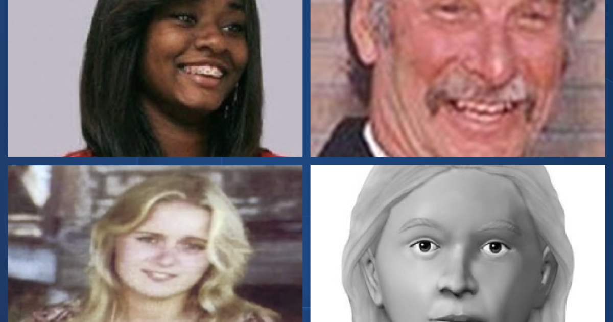
The official report announcing her identity stated that she was found at mile marker 151.8 on the north side (westbound) of I-40. Carolyn was seen at the truck stop on Monte Carlo Rd, which is exit #149. Mile marker numbers get smaller westbound as you approach the California state line. The only way Carolyn was found at MM 151.8 is if whomever killed her went EASTBOUND for a while and then turned back west to dump the body east of the truck stop.

Perhaps the mile marker in the announcement is incorrect? Any other thoughts?

I believe 151.8 is correct. It jives with the article you linked on the prior page, which said, "Short said an officer with the Department of Public Safety was dispatched to help a motorist on I-40 at the 152 mile marker near the county line. The motorist had tire trouble, and the officer was walking along the westbound side of the highway at the scene when he came upon the body tucked under a juniper tree, snow still lingering in the area."

It's possible the mile markers have changed over the years. I've seen that in many states, including here in Florida. For a long time exits would like the current number followed by the prior one, like "Old 152." That happens when there is an addition or rerouting and the number of miles changes. In this instance if the number declined they may have straightened I-40 somewhere for a few miles to eliminate a dangerous bend, or something like that.

I have done this in other cases like Sumter County Does, provided a link to Google Maps if anyone wants to get a glimpse of the actual spot and route taken. This link is from the westbound lanes of I-40 just prior to the Monte Carlo Road exit. It is indeed #149 present day. You can move the cursor forward and advance, including taking the exit. You can keep going on I-40 and approximate the area where she was found, although that is more difficult if the mile markers have changed:

Google Maps

Unfortunately Google Maps will not allow me to advance on Monte Carlo Road. However, I was able to zoom in from the exit ramp toward the old restaurant. I recognize it from some of the recent news clips. The building still stands even though it is long shut down. This is where Valentine Sally spoke to the waitress and spent some of her final moments. It is reached by an immediate right at the end of the exit ramp:

Google Maps

It is correct that the first mile marker west of the Monte Carlo Road exit is currently 149:

Google Maps

This may be the approximate area where the body was found. The link on the prior page says the site was near the county line. The waitress Patty Wilkins said the body was found only about a mile from the restaurant. I didn't realize the next westbound exit was so close to the truck stop. It is indeed numbered only one mile lower -- 148 from 149 -- and is called County Line Road. Perhaps the killer pulled over just prior to the next exit ramp, or on it. Very rare to have two interstate exits within one mile in such a lowly populated area:

Google Maps
 
Last edited:
I believe 151.8 is correct. It jives with the article you linked on the prior page, which said, "Short said an officer with the Department of Public Safety was dispatched to help a motorist on I-40 at the 152 mile marker near the county line. The motorist had tire trouble, and the officer was walking along the westbound side of the highway at the scene when he came upon the body tucked under a juniper tree, snow still lingering in the area."

It's possible the mile markers have changed over the years. I've seen that in many states, including here in Florida. For a long time exits would like the current number followed by the prior one, like "Old 152." That happens when there is an addition or rerouting and the number of miles changes. ....

Snipped and bolded for clarity.

I agree; I live in a state (PA) where highway mile-marker and exit renumbering is endemic. It wouldn't surprise me if Arizona were another such state, as it seems to me that whenever I visit (once every ten years or so) there is always some major highway construction involving new exits and entrances being added, bypasses in some areas, new sections built to give easier access to towns that were formerly remote from the highway network, rerouting to avoid areas of worsening erosion, improve structural integrity, etc. In addition, this is merely an anecdotal observation but it seems to me that prior to 30 or 40 years ago, many highway mile markers were far less precise (no .1 mile increments, for one thing) than they are now. There also used to be less keying of exit numbers to the mile measure, even on interstates. That has only become standard in the past decade or so in some areas. (For example in the aforementioned, always-quirky PA.)

I'm just a driver, by no means a roads/infrastructure expert, so there are probably others here at Websleuths who are more familiar with the changes to major state and national highway systems over the past 40 years.

Those are all excellent points. Here in Florida I used to know specific exit numbers on the Turnpike or I-95 by number, then had to relearn them. There are also states that previously used to number sequentially (1,2) regardless if it was 30 miles until the next exit. Some states still use that while others now have switched to exit numbers conforming to the mile marker. As someone who pushes too hard and drives late into the night the later method is extremely helpful. I don't have to guess how many miles until I reach destination...just 38 more until exit 179

Let me try this again with Valentine Sally, regarding approximate body location. Every time I start tinkering with Google Maps Street View I keep tinkering. Since they gave us such a specific at westbound mile marker 151.8 I'm thinking that must be the current 148.8. After all, these states don't want to dig up every mile marker and move them a few hundred yards. They'll change 152 to 149 and say that's good enough. I didn't see 1/10 mile markers on I-40. There are some white stakes that seem approximately every 1/10 mile. Advancing roughly 400 yards westward of mile marker 149 would lead to this area. There are plentiful trees available at right and a slightly wider than normal pull off area. Both seem helpful for someone looking to quickly dispose of a body. Of course, who knows if it was similar in 1982. But I always like to envision the area where these crimes occurred. This photo also shows the shadow of the camera from the vehicle. That's how Google Maps Street View is taken every few years. This is from December 2018:

Google Maps
I grew up here in N. AZ and just last week I was traveling on I-40 both directions. The interstate through most of Arizona has remained relatively unchanged so I don't suspect that the mile markers have changed but this is just a guess. In one of the things I was reading it said that she told the guy she was traveling with that she was headed to Flagstaff. I think he gave her a ride from Phoenix and was supposed to be heading back East. This little detail, if accurate always bothered me because going that far west on 1-40 is the opposite direction of Flagstaff. Further if they stopped at the Monte Carlo truck stop it makes no sense to go one direction then head back the other. County Line road is about a mile west of the Monte Carlo exit and going east bound there is no where to turn around (exit) until you get almost into Williams. I believe the next exist is Devil Dog Road which is around 10 miles (?) east of Monte Carlo. Anyway driving that stretch I thought about her and was looking for somewhere that might fit her body being dumped (I couldn't remember the MM). Going east you start to climb a big hill that is pretty steep that goes on for about 5 -6 miles. Before you start the climb there is a pull out where trucks (and others) put on chains in the winter time as this road gets snow packed and icy. This is where I thought she was found.
 
I grew up here in N. AZ and just last week I was traveling on I-40 both directions. The interstate through most of Arizona has remained relatively unchanged so I don't suspect that the mile markers have changed but this is just a guess. In one of the things I was reading it said that she told the guy she was traveling with that she was headed to Flagstaff. I think he gave her a ride from Phoenix and was supposed to be heading back East. This little detail, if accurate always bothered me because going that far west on 1-40 is the opposite direction of Flagstaff. Further if they stopped at the Monte Carlo truck stop it makes no sense to go one direction then head back the other. County Line road is about a mile west of the Monte Carlo exit and going east bound there is no where to turn around (exit) until you get almost into Williams. I believe the next exist is Devil Dog Road which is around 10 miles (?) east of Monte Carlo. Anyway driving that stretch I thought about her and was looking for somewhere that might fit her body being dumped (I couldn't remember the MM). Going east you start to climb a big hill that is pretty steep that goes on for about 5 -6 miles. Before you start the climb there is a pull out where trucks (and others) put on chains in the winter time as this road gets snow packed and icy. This is where I thought she was found.
I remember reading on a news article, published after her ID, stating that her body was found on a steep climb, which is the area where trucks would pull over.
 
1002563146-photo-u1

Photo: CarlK90245 / Wikimedia Commons / CC-BY-SA 4.0
‘Valentine Sally,’ Now Known To Be Carolyn Eaton, Was Found At A Popular Truck Stop On Valentine’s Day
The body of a young woman was found along Interstate 40 in Arizona on February 14, 1982, leading to her being known as "Valentine Sally." It would take nearly 40 years to identify the girl as 17-year-old Carolyn Eaton. Eaton reportedly ran away from her home in St. Louis after an argument around Christmas 1981, and was last sighted at a truck stop in Arizona. Patty Wilkins, a former waitress at the truck stop's diner, reported seeing a girl matching Eaton's description on February 2, 1982. The girl had come into the truck stop with a man in a cowboy hat with a peacock feather. Wilkins gave Eaton some aspirin after she mentioned having a toothache. Wilkins later said:

I could have pulled her off that truck... I could have forced her to stay with me. I could have called 911. I could have done a million different things that I didn’t do.

The teenager's body was eventually found about a mile from the truck stop. Wilkins said that after the autopsy, investigators told her the aspirin was still on Eaton's tooth
11 Jane And John Does Who Got Their Names Back In 2021
 
Ottis O'toole wore a Texan hat with feathers. Carolyn Eaton was seen with two elderly men at a truck stop with her. Witnesses said the two resembled each other. I wonder if the other man was Henry Lee Lucas. Just speculating.


Members online

Online statistics

Members online
144
Guests online
4,489
Total visitors
4,633

Forum statistics

Threads
592,541
Messages
17,970,711
Members
228,804
Latest member
MeanBean
Back
Top