
Richrd
Ten Year Member
- Joined
- Jan 15, 2014
- Messages
- 9,281
- Reaction score
- 10,597
<modsnip: removed stock image>
GRAPHIC Radio Traffic:
 www.news4jax.com
Generic:
Altitude = Distance above Ground
ASN = Aviation Safety Network - 371054
ATC = Air Traffic Control
CVR = Cockpit Voice Recorder
Elevation = Distance above Sea Level
FAA = Federal Aviation Adminitration
FDR = Flight Date Recorder
IFR = Instrument Flight Rules
ILS = Instrument Landing System Approach
Knot = 1.15 Miles per Hour
ME = Medical Examiner
NTSB = National Transportation Safety Board
Runway 13 = Compass Pointing to 130 Degrees upon Take-Off
VFR = Visual Flight Rules
.
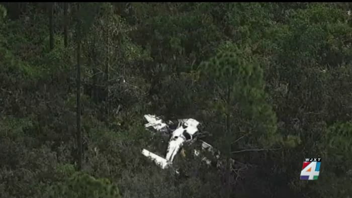
Accident Mooney M20K 252 TSE N4387W,
A Mooney M20K 252 TSE crashed in a wooded area about three minutes after departure from runway 13 at Northeast Florida Regional Airport (SGJ/KSGJ), St. Agustine, Florida. The two occupant...
aviation-safety.net
GRAPHIC Radio Traffic:
2 die after airplane crashes into wooded area near St. Augustine airport
The St. Johns County Sheriff’s Office and other agencies are responding to an airplane crash that happened shortly after the aircraft took off from the Northeast Florida Regional Airport in St. Augustine Monday around noon.
Fatal St. Augustine Plane Crash - Google Search
www.google.com
Generic:
Altitude = Distance above Ground
ASN = Aviation Safety Network - 371054
ATC = Air Traffic Control
CVR = Cockpit Voice Recorder
Elevation = Distance above Sea Level
FAA = Federal Aviation Adminitration
FDR = Flight Date Recorder
IFR = Instrument Flight Rules
ILS = Instrument Landing System Approach
Knot = 1.15 Miles per Hour
ME = Medical Examiner
NTSB = National Transportation Safety Board
Runway 13 = Compass Pointing to 130 Degrees upon Take-Off
VFR = Visual Flight Rules
.
Last edited by a moderator: