PayrollNerd
Well-Known Member
- Joined
- Feb 3, 2018
- Messages
- 17,843
- Reaction score
- 104,945
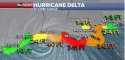
It came in just south of Cancun as a Cat 2. Those winds on the right (East) side are going to pull in the storm surge. Hope everyone got out!
Live Updates: Hurricane Delta makes landfall in Mexico as Category 2 storm, still 'extremely dangerous'
As of 7 a.m. EDT on Wednesday the storm made landfall along the coast of northeastern Mexico near Puerto Morelos, about 20 miles south of Cancun. The storm is packing maximum sustained winds of 110 mph.