Maps & Aerial Photos *** NO DISCUSSION ***

http://fios1news.com/longisland/node/9617

Here is a picture of their locations along with the approximate areas circled. I roughly cross referenced the belongings using houses on the map of where she and her belongings were found, which is more from the side of the area rather than directly above it. As you can see, there are a quite a few of these drainage ditches. I found it interesting that her belongings were found close to an "intersection" of the ditches. After watching the video again, it probably would be too dangerous to try to walk through there unless it hasn't rained much.

DrainageDitchesinRelationtoShannonsBelongingsandBody_2920.jpg


I'm looking forward to what you can come up with from the area!
 
This is one west of Tobay Beach. Anyone have an idea what that could possibly be? It just looks like a bunch of abandoned buildings on an unnamed road.
 

Attachments

  • Screenshot_2012-09-26-16-58-55.png
    Screenshot_2012-09-26-16-58-55.png
    810 KB · Views: 49
  • Screenshot_2012-09-26-16-59-28.png
    Screenshot_2012-09-26-16-59-28.png
    977.9 KB · Views: 40
  • Screenshot_2012-09-26-17-02-06.png
    Screenshot_2012-09-26-17-02-06.png
    968.4 KB · Views: 34
  • Screenshot_2012-09-26-17-01-39.png
    Screenshot_2012-09-26-17-01-39.png
    553.2 KB · Views: 37
I am fortunate to have access to thousands of High Definition Arial images. Here is the link to the first album that I uploaded back in the Spring;

High Def Photos

As you can see, those images are taken from a great height. In my library I actually have many images that are zoomed in much closer to the ground than you see in that first album. I also am fortunate to have photos of many of the same locations from 2006 as well as from 2011 (with up to a dozen photos of each location from North, South, East & West). As you can imagine, sorting through thousands of photos is extremely time consuming. Since SCPD has zoned in on the marsh/swamp area just East of Anchors Way in Oak Beach, I am working on uploading images that are specific to the wetlands being searched in a new album that can be found here;

Oak Beach Association Wetlands

This is what the area looks like on Google Maps;
Googleimageofswamp.png


I just started uploading photos into that album so please be patient and visit back often. I am also going to post several photos here in this thread from that album for areas that I feel are of interest (visit this thread in about a half hour from the time I started it to see the first series of photos).

bump - I can't remember how they focused in on that area to search for Shannan, did they get a tip? So strange - they never brought in excavators or heavy equipment for the other searches...right?
 
Thanks for the effort put into that post hawkshaw, a lot of knowledge there to absorb. As far as a more logical explanation as to the cause of death, hypothermia should not be overlooked. It has happened to much stronger people than her and even in warmer conditions than you had that early morning in the brambles. The incident down in Fl at camp rudder comes to mind where we lost four Rangers while training out on a swollen river after disembarking their raft and slogging through the swamp. I don't know how much water the area she traversed had in it at the time but I would imagine she was both wet and exhausted after the quarter mile trek not to mention her mental state, her body might have just shut down at that point in which case you would not find a cause of death. I also cant help but to think it would've took only a few hundred dollars and a chopper to find her the next day and more than likely on dry ground, leaving the other remains perhaps going undiscovered for who knows how long.
 
Hawkshaw, the police talked about finding SG personal items. Are they allowed to talk about items that were found with her remains if there were any? According to footnotes GC said here jacket was over her shoulder. If my memory serves me correctly EM of 48 hours stated that JB said her jacket was on the ground in his driveway for several days. I wonder if he really said that or was that crappy reporting. If so where is her jacket?
 
LR1- I read your post and I have to say it does make sense, i.e., SG died of exposure. It makes a lot of sense. The area is isolated. It is wet. It may also be an area where people go to be alone to hike and get connected to their inner self. They may also be like cats that when they are about to die go somewhere to hide and die alone. Is it possible SG, GB4, and the others all went to the same place they knew to be a ritual dying zone to spend their last moments on Earth? JUST KIDDING. I am not trying to make fun of you. Anything is possible. But I think one has to go with what they know before venturing into the unknown.

SG was a hooker advertising on Craigslist. The GB 4 also advertised on GL.
They were all found dead at the same location.
SG made a phone call saying someone was trying to kill her.

This is pretty much what we know. What the cops know is unknown to us. But you can be sure if they have anything they 'want' us to know to make this go away they will make sure they put it out there as they did with the nursery owner.
 
The circled area at the top is the police searching. The circled home belongs to CPH.
searchbehindCPHhouse.png


This is what that area looks like zoomed in from the sky from the South;
searchareafromSouth.png


And this is what that area looks like when viewed from overhead. The canal that comes from the top left at an angle is the one that originates at Anchor way along the new trail that was cut. As you can see, that canal forks. The horizontal fork cuts right across the marsh towards Truthspider's area of interest (see posts above). The vertical fork of the canal runs almost up to CPH's rear yard. I will try to post more on that in a minute.
searchareafromabove.png


When I responded to hawkshaw upstream a few days ago when he was looking for a "more logical explanation" to her drowning in "no more than a foot or so" of water I recalled the deaths of 4 Army Rangers down in FL. years ago who died of hypothermia during training in the swamp in slightly warmer weather than you had that morning on Oak beach. it struck me that this whether alone or in combination with other factors could be a possibility in her case and shouldn't be overlooked as funny and stupid as that sounds.

Now if I were to be tasked with coming up with a scenario regarding why (other than being dumped there by a killer) her belongings were found where they were in relation to her remains. Take a look at the pictures above and I'll try to paint a "plausible scenario" for you. Firstly we know the 911 call came in at 4:51 if they lasted 23 minutes then it ended at 5:14 give or take. Iv'e read where MRS B's 911 call came in at 5:22 and surmising she made the call shortly after she seen/heard Shannan, she wouldn't even have been in the marsh while on the phone with 911 so no, no hypothermia yet.

in the top photo from anchor way to where they are digging is roughly 300 feet or the length of a football field. By the way you can look at the historical weather from the area they received close to 2 inches of rain 3-4 days before may 1'st so I'm thinking its at least going to be a little wet. air temp 55 degrees, water temp estimation 45-50 degrees. could not find info on cloud cover.

In the second pic above the red pointer thing and across the horizontal ditch which looks to be 6 feet across in places and likely several feet deep is where her belongings were found. looking at historical imagery on google earth the spot holds a lot of water at times as you can see from the photos.

So she leaves JB in hysterics runs to GC house arriving there in hysterics, connects with him briefly then runs on down the road and instead of seeking help from any other houses which were most likely in view, (civil twilight that day also 5:22) she heads into the marsh. depending on her route, she crossed one or two of the drainage ditches which are full of water to get to where her belongings were found. To me its not beyond the realm of possibilities that she not being able to jump a 6 foot ditch got very wet at that point. and for reasons we'll probably never know decided to get out of those pants. maybe she took them off before trying to cross the ditch and threw them over thinking she would cross and still have semi dry pants when she made it across. From her reported actions the previous 45 minutes or so its hard to tell what was going through her mind. From there and again depending on her route she slugged through a quarter mile of marshland with no pants or shoes. Reaching the far bank she must have heard the cars going by but without pants decided to lay there cold and exhausted.

So whether she drowned, od'd, heart attack, stroke, hypothermia or was murdered. We will probably never know what caused her death because of the lack of effort to look and find her in the obvious place to look which is the last place she was seen, early on in this nightmare. whether it be Suffolk county, friends or family. Now this scenario might sound stupid and not make sense but then again very little about her case makes sense including some other scenarios that have been offered up here.
 
In old 2006 aerial photos I discovered a 4x4 dirt access road along side where Jessica Taylor's skull, hands & forearms were discovered on March 29th in Gilgo State Park. And when I look at the updated photo of the area (taken 4/4/11) that dirt access road no longer exists!!

I wonder if the police investigators are aware. It had always been speculated that perhaps the SK threw her remains into the brush from Ocean Parkway (because the brush was so thick going in from Ocean Parkway).

But what if he simply drove up the access road?

He stood little chance of being caught when he got out of his car because I doubt the dirt road was used very much.

Better yet, at the other end of this road is access to a beach with deep water right up to the shoreline. What if our serial killer accessed the area from boat in the middle of the night and walked her remains up to the highway end of the access road to make it look like her remains were thrown from a vehicle?

This is one of many photos taken 4/4/11 of where Jessica Taylor's remains were found;
JessicaTaylorbodypartsphototakenApril42011.jpg


Here is another;
JessicataylortakenApril42011.png


Now this is sooooo creepy...

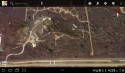
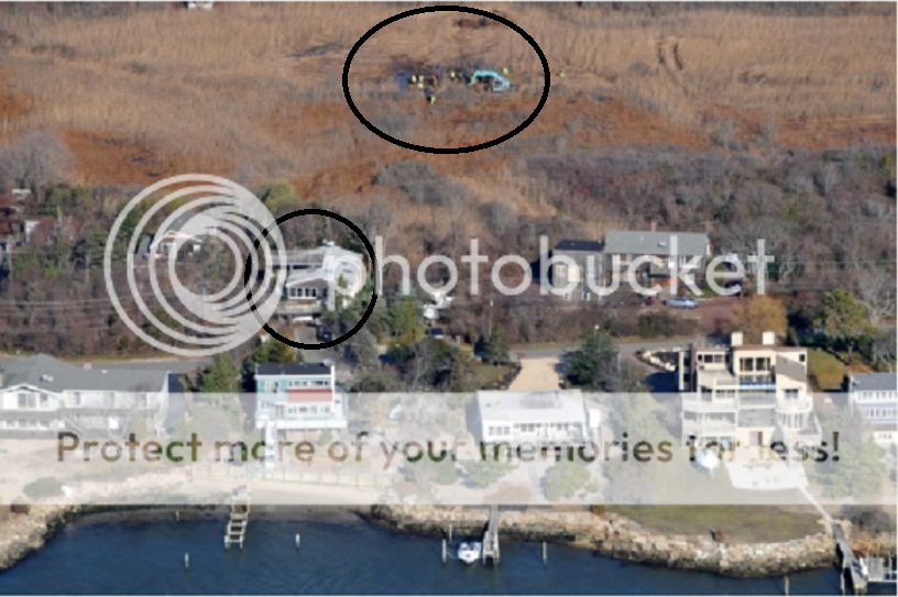
Here is a view of the exact same area from March 2006. I used triangulation between the center of two trees to measure exactly where Jessica Taylor's remains were found and I placed an X at that location in this photo. You can clearly see the dirt access road for four wheelers just to the East of where her remains were found. If you look at the photo above, this road is completely hidden under the brush now.

Here is the photo-
JessicaTaylorremainsnear4x4road2ndphotoMarch2006.png


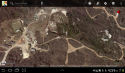
Here is another view of the entire road;
4x4Accessroad3rdphototalenMarch282006.png


What bothers me is that if the investigators did not know that this road existed, they may not have tried searching the land to the East and West along side where the road stood all the way North to where the road ends at the bay. I am seriously getting the creeps. That area at the very end of the road is so far from any homes or roads that it is very possibly that area could have been our SK's early kill site. A victim could scream at the top of her lungs for hours with no chance of anyone hearing her/him. The SK and any victims he brought there would have been completely isolated from the rest of the world and could have butchered bodies right there on that bay coast line without any chance of being discovered! It was determined that Jessica Taylor was not killed at the location in Manorville where her torso was placed out in the open. Ever since the rest of her remains were found at Gilgo it has been assumed that she was killed in a third location separate from Manorville and Gilgo.

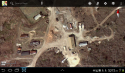
This is a photo of the end of that road with an isolated hard sandy area over 600 feet long and 100 feet wide. It could easily had been his early kill site and law enforcement needs to be notified to search it;
endofroadpossiblekillsite.png


Here is another image of the forgotten 4x4 access road from end to end. Notice the beach access to the bottom right where the water is deep enough for even a larger boat to pull bow first right into the beach!
4x4Accessroad2ndphototalenMarch282006.png


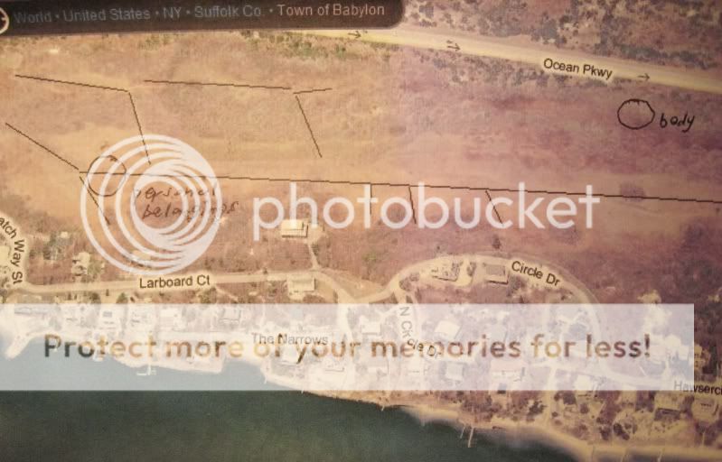
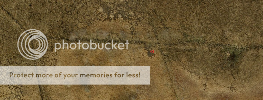
And here is one more closeup of the entrance with an arrow pointing to where the search discovered some of Jessica Taylor's remains;
JessicaTaylorremainsnear4x4roadMarch2006.png


UPDATE: I just submitted this info to Suffolk Crime Stoppers. Just need to wait for them to sift through the 1,200 under tips so they can get to this one.

Did crime stoppers ever get back to you about this huge tip?

You made a huge discovery here. Why hasn't the media ever reported this old road?
 
This 'road' is not a NYS 4X4 permit access road. (as per the state site) So, if that is the case - it's either illegal to use it or it's a service road for town/state employees. This has sparked my interest a lot. Thank you.
 
This 'road' is not a NYS 4X4 permit access road. (as per the state site) So, if that is the case - it's either illegal to use it or it's a service road for town/state employees. This has sparked my interest a lot. Thank you.
Exactly! That is why I keep saying that someone was forging tracks through the brush and most likely with some sort of ATV...whether it was legal or not it happened. Seaslug has proven it by showing these aerials. If I am not mistaken, it was also Seaslug who provided us with the very clear aerial images of the well cut path from where SG was found to the OP. LIN also told us several times that there was a well known and well worn foot path, right next to where the GB4 were found, from the bay side to the OP.

Surprisingly, there are OB residents who insist that because this would be illegal that it doesn't happen. BUT, someone cut those paths and most likely some of the paths were cut by ATVs or even Jeep-like vehicles.
 
Confirmed by TOB. That trail is not there for town use.

It's not a trail. It's the path left by one pass of the tracked vehicle as it crossed the brush leaving the marsh after cutting the mosquito ditches. The tracks it leaves on the salt hay vanish in one year/growing cycle. The tracks through the brush take a few years to vanish.
 
That doesn't account for the wide trail from the shore to where JT's head was found. There is no sign of any mosquito ditches cut there at the time these photos were taken.
 
That doesn't account for the wide trail from the shore to where JT's head was found. There is no sign of any mosquito ditches cut there at the time these photos were taken.

Hi Just K, I don't really know what trail you are talking about, and I don't see one in the photos posted above. All I see is the evidence of the path left by the tracked vehicle that cuts the ditches almost, but not quite, grown over.
The ditches themselves are not in the photos and are generally more north on the marsh where the grade is flatter and water stands.
 
Let me add that the area in the oval that is labeled as a hard sandy area is nothing more that salt hay cut by winter ice and moved to one spot by wind and tide. Walking on it is like walking on a very thick soft mattress, and be very careful to avoid the driftwood with nails sticking out that's all over and buried under it.
Also, the east end of that cove(the spot called deep)is not that deep. Even a small boat needs the motor off and tilted up to coast close to the shore.
I know these coves and marshes like the back of my hand.
 
It's not a trail. It's the path left by one pass of the tracked vehicle as it crossed the brush leaving the marsh after cutting the mosquito ditches. The tracks it leaves on the salt hay vanish in one year/growing cycle. The tracks through the brush take a few years to vanish.


It doesn't matter who forged that trail. But in 2006 when Jessica Taylor IIRC was murdered/missing that trail was there. It could have been what attracted the killer to dump her remains there. That it is now grown over (in the 2011) photos is not important. :twocents:
 
Mcme-what is the trail that I alwas reference? The one that is accessible from OP and is just west of RMC
 
I usually just read this thread without commenting...sometimes you learn more from just listening without feeling the need to insert your 2 cents. But I do want to make an exception this morning just to thank everyone for their part in making this such an intelligent, thought provoking thread. Well done, guys! :)
 

Members online

Online statistics

Members online
100
Guests online
3,633
Total visitors
3,733

Forum statistics

Threads
592,548
Messages
17,970,776
Members
228,805
Latest member
Val in PA
Back
Top