New Guinea - Amelia Earhart & Fred Noonan, en route to Howland Island, 2 July 1937

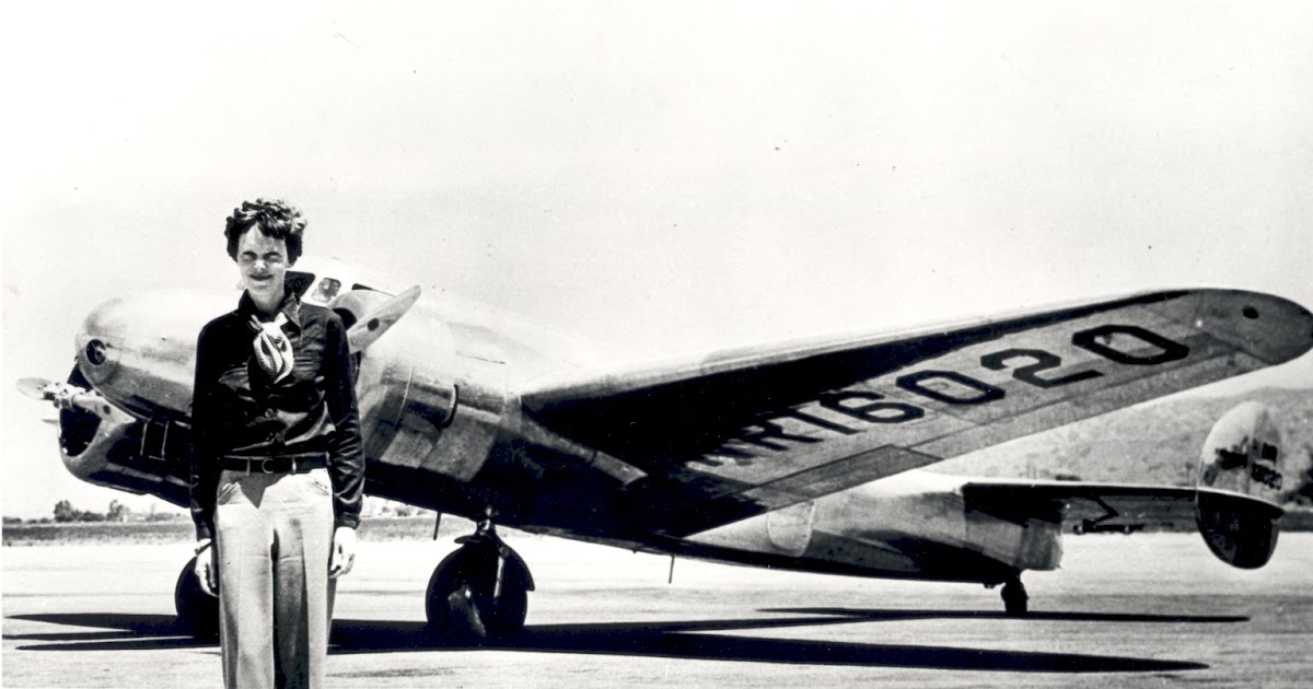
Interesting comments on radio propagation and theories about possible ways to locate Amelia.

If anybody had received signals from Amelia, they would have been receiving sky waves, rather than direct path transmissions. Sky waves occur when a transmitted radio signal bounces off the ionosphere and returns to earth. Depending on the initial strength and atmospheric conditions, these sky waves can "bounce" several times and cover many miles.

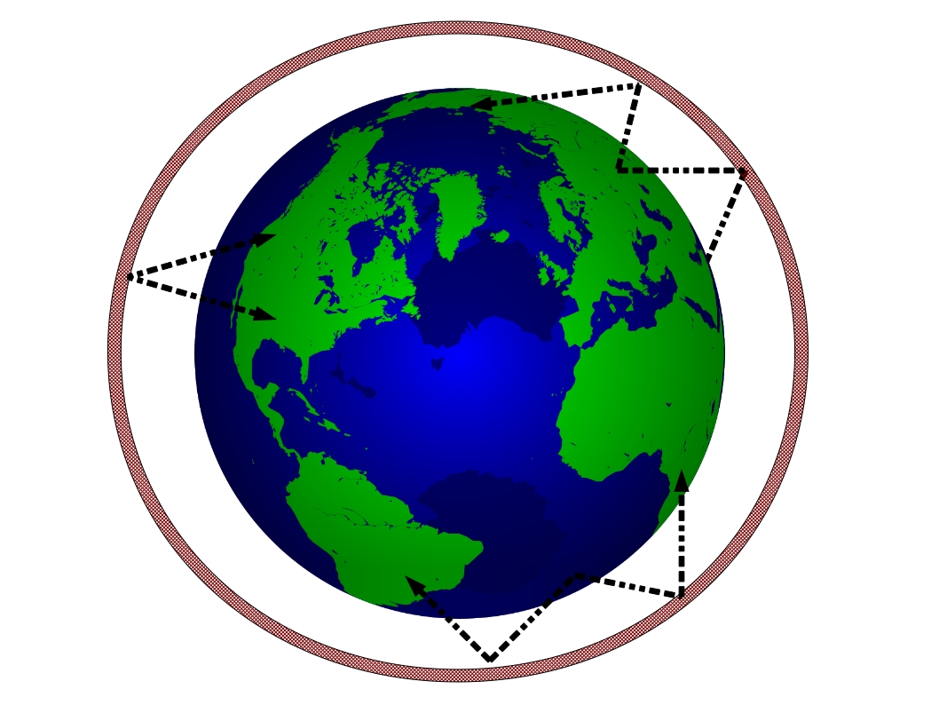
Drawings made to illustrate Sky Wave Propagation always show simple single lines extending from a transmitting antenna, up to the ionosphere, and then back to a receiving antenna on earth. In actuality, areas of sky wave coverage would tend to plot out on a map as rings inside which a receiver might pick up a transmission on either the initial frequency or maybe a harmonic of that frequency.

Many factors can affect sky waves - time of day, temperature, interference from other signals, location of the receiving station, power, size of antenna, etc. etc. As atmospherics change, a signal might get stronger or fade out.

Night time is best for picking up sky wave signals. You can see this by tuning in stations on an old AM radio. On a good night, you might pick up a station from a state on the other side of the country.

One station might pick up a signal, but another, just outside the ring of sky wave convergence might not.

LINKS:


Last edited:
Here is an interesting website with a video about the Gardner Island theory and the associated archaeology efforts. It is associated with the TIGHAR group. The comments section below the video are interesting to read, with different ideas about Amelia and Fred's disappearance.

LINK:

 
Here is an interesting website with a video about the Gardner Island theory and the associated archaeology efforts. It is associated with the TIGHAR group. The comments section below the video are interesting to read, with different ideas about Amelia and Fred's disappearance.

LINK:

Thanks for sharing; I liked the comments, though I'm amazed at times. I couldn't take the video, though--over an hour? I can read in 15 minutes what it takes an hour to do on video, and I'm not very patient about watching video screens. :-/

The pilot in the comments who talked about how AE/FN certainly would have explicit plans about fuel and not finding the island, sounds exactly correct to me. I need to find (for you, Richard) the book that argued that the Electra turned back early, not long affter Nauru. Also (same one?) that argued about how plausible Saipan and civilian control was--there was a lot about the Saipanese witnesses that you'd find interesting. (I did, and I still think it's hokum. But I'm still considering all the facts anybody wants to offer.) ;-)

Did I mention that one of the books brought out that Putnam said AE wore pairs of his boxer shorts while flying, for comfort? And we know she wore men's clodhoppers while flying. I joked to Mrs Ken that between that and the haircut, I thought AE wasn't spying on Japanese military construction, she was scouting for a location for the first Lilith Fair. :) I bet if I say that here, a moderator will delete it. And it serves me right, too! :)

I'm attaching another screenshot: faulty information: rubber raft, water-distilling gear. Not true, it seems likely. I read recently that--wish I'd thought of this myself--even floating, the Electra would be strongly nose-down, cockpit in the water, from the engines' weight. So the dynamotor(s) under the seat certainly would have been unusable afloat. I need to check to see if her WE transmitter might have had its own dynanmotor--some small portable receivers did, as I found. Oh, and one author said being a low-winged plane, the Electra would have been hard to land on water--wingtip catches before plane is fully settled, remember the Seychelles hijacking that ended that way? :-(
 

Attachments

  • 1937 07 05 Melbourne The Age Pg11shots001.jpg
    1937 07 05 Melbourne The Age Pg11shots001.jpg
    297.2 KB · Views: 2
Amelia was actually quite a fashion conscious person as can be seen in so many photos of her at various events and public appearances. She was, however, very practical in regard to the clothing she wore on and around airplanes.

Many of the Islander witnesses spoke of a woman pilot who wore men's clothing and had short hair - although they did not know who Amelia Earhart was.

The newspaper clippings dated only days after Amelia and Fred's disappearance clearly show the intense search and rescue effort which was underway. The stories mentioned many radio operators who believed that they had heard Amelia and it was clear that many believed at the time that she and Fred may have landed on a small island.

Interesting bits of information regarding their survival supplies. I have never heard of a water distilling kit using human breath to make drinking water, though. I think there must have been some misunderstanding (or creative writing) on the part of the reporter. Note that although they supposedly had a kite, no emergency radio equipment is mentioned - which would probably have been the most important survival item for them to have.
 
Last edited:
... snipped: I'm attaching another screenshot: faulty information: rubber raft, water-distilling gear. Not true, it seems likely. I read recently that--wish I'd thought of this myself--even floating, the Electra would be strongly nose-down, cockpit in the water, from the engines' weight. So the dynamotor(s) under the seat certainly would have been unusable afloat. I need to check to see if her WE transmitter might have had its own dynanmotor--some small portable receivers did, as I found. Oh, and one author said being a low-winged plane, the Electra would have been hard to land on water--wingtip catches before plane is fully settled, remember the Seychelles hijacking that ended that way? :-(

Amelia and Fred did very likely have a rubber life raft on board their plane. Here is a photo of Amelia checking one out. Note, however that she is next to a different plane than the Lockheed Electra 10.

fe3a2fdf1d5c3a4a7af4ac4d9581f040.jpg


Here is a link to a site which shows a number of different life rafts carried aboard US aircraft during World War II. These life rafts contained various types of survival supplies.

Although it is true that many aircraft have a tendency to go "nose down" in the water after ditching, due to the weight of engines, note in the link some photos of multi engine aircraft floating in the water which are not "nose down". One is a B-17 which had four engines. Regardless of the angle in which they are floating, all tend to take on water.

LINK:

 
Last edited:
Final Flight map

Route of Amelia Earhart's flight from Lae, New Guinea to Howland Island. Note the vicinity of other island groups.

Different theories place possible ditching sites on Nikumaroro (Gardner) Island to the south of Howland and Mili Atoll to the north west of Howland.

At their Estimated Time of Arrival (ETA) Howland, the Coast Guard Cutter Itasca (stationed near Howland) was receiving Amelia's HF radio transmissions - so they were within transmission range of the plane's radio, but Amelia could not hear Itasca's transmissions to her. This was likely because of a problem with her radio set and/or antenna selector switch.

Also, she could not see either Itasca or Howland Island, even though Itasca was sending up black smoke for her from the Cutter's stacks.

In her last transmission in the blind, Amelia stated that she was flying north and south along a line roughly perpendicular to her original course line searching for Howland/Itasca. This might have been a radio direction finder bearing that she finally managed to receive on her plane's loop antenna, or it might have been a sun line shot by Fred Noonan at sunrise and advanced along their course line to ETA.

Those who believe that Amelia went down on Gardner Island, take as a "given" that she was actually on a 337/157 degree line passing through Howland Island.

Earhart's Pacific route


The problem here is that we really do not know where Amelia and Fred were in relation to Howland Island. They had been flying for 20 plus hours with no solid fixes or updated wind information. We can probably assume that the plane's altimeter, compass, and airspeed indicator were all working, but over time and distance, winds change - and that is a key vector to factor into one's Dead Reckoning Navigation. They could have easily been left or right of their intended course and their speed over the earth (ground speed) might have been more or less than Fred calculated.

A more realistic approach to the search and rescue problem would be to draw a circle around Howland Island of a distance that her HF radio transmissions would have traveled at an altitude of 1000 feet. Then draw parallel lines of 337/157 on the edges of that circle. This would give a larger area of possibility to search.

Amelia, thought she was "on top" of Howland, and did spend time searching for it. However, not finding it, she might have considered flying BACK in the direction of where she thought other islands or ships might be. This would have been the Gilbert Island chain (see map). Note the relative distance of the Gilberts to Howland vs the distance from Howland to either Gardner Island or Mili Atoll. Again, from Amelia's perspective, perhaps the Gilberts (which she thought she had flown over earlier) seemed a feasible alternate. Depending on her ACTUAL position north or south of Howland, she might have come across either Gardner Island or Mili Atoll.

The Gilbert Islands were territory belonging to Great Britain, while the Marshall Islands (including Mili) to the north were part of the Mandated Islands under Japanese control.

Note that Jaluit Atoll is the island just west of Mili on the first map. This is where the photo of the people on the dock with a ship in the background was taken.

LINKS:


Here is a simple illustration of how wind vectors (wind direction and speed) affect air navigation:


In the top figure, the aircraft is Headed (using the compass) on an intended Course due east (090 degrees), but the wind, coming from the north off the left wing is also moving the aircraft slightly to the south. The resultant area over which the aircraft traveled over the earth (solid line) is it's Track.

The bottom figure shows how the aircraft takes the wind into account and adjusts its compass heading slightly to maintain its desired Course of due east (090 degrees).

To do this successfully and reach your destination, the pilot has to have a good idea of what the winds are. Initially, this is known by receiving forecast winds prior to take-off, but as the navigator obtains fixes along the way, he can compute actual winds (fix to fix) to apply to the aircraft heading.

Winds also affect the speed which the aircraft travels over the earth (its ground speed):

imagePR2.jpg

The pilot has an airspeed instrument in the cockpit which shows his indicated speed through the air mass. It gets this input from a pitot tube outside the aircraft, which compares ram air pressure to static air pressure.

A tail wind component to the wind vector will cause the ground speed to be faster than the aircraft's indicated airspeed (IAS). While a head wind will cause the ground speed to be slower than IAS.

All of this goes directly to our discussion about Amelia and Fred's last flight. If the wind was different than what they had been using for their navigation calculations, they could have been right or left of their intended course, and faster or slower than their intended ground speed. This means they might have been north or south of Howland at their Estimated Time of Arrival (ETA) and/or might have either been short of Howland or had possibly passed by it at ETA.

Unfortunately, nobody knows what fixes or lines of position Fred was able to get on that flight. And since they made no accurate position reports, it is not possible to reliably reconstruct the flight. But without accurate navigation information available to him, wind determination would have been very difficult to obtain. The less information available, the more ambiguity and error are introduced.

LINK:

 
AmeliaFred.JPG

Fred Noonan and Amelia Earhart 1937

Did they survive past 2 July 1937? Were they captured by the Japanese? At the below link is an interesting blog discussion about the Jaluit photo and about Marshallese islanders who claimed to have seen the "pilots" and the aircraft on a Japanese ship.

LINK:

 
I've always thought that was AE sitting on the dock.


jmo


Here is a copy of the photo taken on the dock at Jaluit, probably in July 1937, along with some blown up images from that photo. Some interpret the photo as showing a white man and a white woman with Marshallese Islanders, and suggest that it is a photo of Fred Noonan and Amelia Earhart.

In the background, past the sail boat, is the Japanese Survey ship Koshu, possibly loading an airplane on to its stern.

Koshu.jpg
I thought it had been shown that these photos predated Amelia's flight.
 
I thought it had been shown that these photos predated Amelia's flight.
A Japanese researcher, Kota Yamano made that claim based upon finding a copy of the photo inside a personal one-of-a-kind album of photos by the photographer. That string bound album also included an envelope or paper with a stamp postmark or date stamp of 1935. That was not a copyright date or publication date, simply a piece of paper that was included in the photo collection.

In 2017, a History Channel program that suggested Fred and Amelia had been captured by the Japanese had offered this photo as proof. It was soon challenged by Kota Yamano - and the TIGHAR group jumped on Kota's research, loudly proclaiming the photo to be NOT Fred, Amelia, and the Electra. They summarized their reasons on their website:
(Quote)
  • The photo was not misfiled.
  • The person alleged to be Amelia cannot be identified.
  • The man is not Noonan.
  • The ship is not the Koshu.
  • There is no barge with an airplane.
TIGHAR will continue our investigation of this fiasco.
(Unquote)

No further word from TIGHAR regarding their further "investigation".

It should be pointed out that TIGHAR was continually trying to raise money for more Gardner Island (Nikamororo) expeditions. They therefore had strong reasons to argue against and to cast doubt on any other theory. But while they have strong reasons to NOT want to accept this photo, simply saying "It ain't so" with weak nonsensical arguments does not disprove the possibility that Fred and Amelia might have landed in the Marshall Islands rather than on Gardner Island.

Marshall Islanders state that the Jaluit dock in the photo was built some time during 1936, which would mean that the photo had to have been taken some time after - certainly later than the 1935 date.

The ship in the photo is indeed the Koshu. So the photo had to have been taken some time between 1936 (when the new dock was built) and April 1940 when Koshu was dismantled/scrapped.

Logs or reports of Koshu place the ship in Jaluit Harbor in mid July 1937 and an islander named Bilimon Amaron testified that he was taken aboard Koshu in Jaluit to treat a white man and woman for injuries and that he saw a silver aircraft on the ship's stern at the time.

Other islanders have also testified as to having loaded an airplane onto a barge at Mili atoll, and about seeing two "pilots" a man and a woman.

LINKS:

 
Last edited:
Richard, very interesting. Thanks for the information. Hopefully I'll have some time to follow up on this.

I had never given much credence to the "captured by the Japanese" theory. When this photo came out several years ago there were lots of stories about it and I actually looked into them and realized that theory was not as far fetched as I had previously thought. And that really has nothing to do with whether this photo is of Amelia and Fred or not. It may or may not be, but even if it isn't, that doesn't mean that Amelian didn't end up in the Marshal Islands.
 
The story that Amelia and Fred landed in the Marshall Islands is certainly not a new one. On 7 January 1939, a Confidential US Intelligence report was generated based on information received from French Intelligence sources.

The specific information concerning Amelia was reported to have been found in a bottle found on the coast of France. The unknown writer of the message claimed to a Frenchman who had also been held prisoner by the Japanese in Jaluit, but to have been taken on as a seaman aboard a Japanese merchant ship. It was allegedly from this ship that he threw the message bottle(s).

The report goes into detail about Eric de Bisschop, a former French Naval Officer and adventurer who stated that he had visited Jaluit and was also detained there (both before and after 1937). He describes the rapid military build-up taking place in and around the Marshalls and the intense security level by the Japanese there.

Here is that (declassified in 1977) report:


refer to caption


refer to caption


refer to caption


LINKS:


It seems odd to me that Amelia and Fred, unable to locate Howland, but knowing that they had to be in the vicinity, would have turned to Gardner island. Find it would be a total crap shoot. It would have been a far better option to just head due west for the Gilberts. But why didn't she radio her intention to try for either?
 
It seems odd to me that Amelia and Fred, unable to locate Howland, but knowing that they had to be in the vicinity, would have turned to Gardner island. Find it would be a total crap shoot. It would have been a far better option to just head due west for the Gilberts. But why didn't she radio her intention to try for either?

Not finding Howland Island after spending as much time and fuel as she thought prudent, Amelia probably DID turn back to the West, hoping to find an alternate landing place.

The Gilbert Islands are spread north to south across her original course. Regardless of their plane's actual location, a West heading would give them the best chance of finding another island (see map in post 366).

Heading East was not an option because there was nothing to the East of Howland but a vast, open Pacific Ocean.

If Amelia and Fred were absolutely certain that they were on top of Howland and for some reason had to land elsewhere, then Gardner Island might be a viable choice. The problem is that they did NOT know exactly where they were and indeed, finding Gardner would have been total luck.

If they happened to be south of Howland and simply ran across Gardner at Bingo fuel, they certainly might have landed there. However, since they did NOT know exactly where they were, heading South would not have been the best choice.
If they were actually south or east of Howland Island, then heading West would have brought them into the Island group where Gardner is.

It is possible that she could have been a few hundred miles north of Howland Island at ETA. She had been flying for over 20 hours, and if winds were stronger than anticipated from the south they may have drifted left of course by that much. If she was actually north of Howland, then a decision to head West would have brought her into the Marshall Islands rather than the Gilberts.

At any rate, heading West would have been her best choice.

Amelia did not state her intentions other than broadcasting in the blind her last message that she was flying up and down a 337/157 degree course looking for Howland. Then radio silence. It is possible that she may have lost an engine which was powering her radio at that point. We just don't know.

She might have gone into the ocean, she might have found Gardner Island and made a landing on it, or she might also have found Mili Atoll, or any other island for an emergency landing/ditching.

What became of Amelia Earhart and Fred Noonan is a mystery with many possibilities, but no solid answers.
 
Last edited:
Richard, I think you pretty much nailed it. It just didn't make much sense to try to find Gardner when they didn't know where they were to begin with.

I really do wonder where she was when she thought she should be at Howland. I remember watching a program years ago about some radio guys that were analyzing the transmissions received by the Itasca. They determined she had to be pretty close based upon the strength and clarity of her voice messages as reported by Itasca. Was she north, south, was she short and to the west/southwest?

First, Richard, marvelous summary about why trying to find Gardner on her sun line would have been meaningless; if you're already lost, following a given course from an unknown spot makes one more lost, not less.

Prairie, the radio evidence you cite is IMO far and away the best data we have. (Shortwave radio is one thing I have 50 years of experience with.) And IMO the radio evidence (Leo Bellarts' log) clearly says AE/FN passed very near Howland when they were very low on fuel, and splashed near there. It's a Occam's Razor evaluation, based on the only good evidence we have, and I say it's 98% certain. That's just MHO.

Several sources say the Electra did NOT have a raft on board--AE was obsessed with reducing weight and the Lae takeoff shows she was right to be. But there was no raft and darned little in the way of supplies. The Electra might have floated for a while, or it might have sunk rapidly due to structural damage. (Richard can tell us more about a deadstick landing in a low-winged monoplane on water.)

Everything else in the way of "evidence" is bogus IMO. That photo? I can't tell if it's an Anglo or a Pacific Islander, man or woman, much less say "that's Amelia on the dock at Jaluit." The Frenchman was treated with hostility on Jaluit--why would Amelia and Fred have been strolling the dock without guards during a military operation?

Local eyewitness testimony, twenty years after the fact? Almost totally meaningless IMO; "best evidence" weight of <1% IMO. Find ARTIFACTS to prove a case, not my grandmother in her dotage. Guesses, rumors, "the madness of crowds." The post-splash radio? NONE of it is credible IMO. None. And long-range HF directionfinding was meanningless in those days farther than 50-100 miles (Richard wrote well about the "sky wave" issue, which is well documented in the literature.)

The best evidence we have, IMO, is the experienced radiomen who were certain AE was very close to Itasca 30min before splashing. There's just no significant and credible evidence for anything else, IMO. --ken ac4rd (eta radio stuff: AC4RD Callsign Page )
 
Last edited:
The radio logs of the Itasca are important documents in any attempt to learn Amelia Earhart's location.

What was the direct path range of her transmitter at her reported altitude when first heard by Itasca? Knowing that, as well as her average ground speed might give an idea as to whether she was ahead of or behind her Estimated Time of Arrival (ETA) at Howland/Itasca.

Unfortunately, Amelia did not report any of her previous positions, altitudes, or give her Estimated Time of Arrival in her broadcasts, as far as I know. When she reports being "on top" of Itasca, she states that her altitude is 1000 feet.

Recorded signal strengths could be important clues. As she got closer to Itasca, her signal strength would have gotten stronger. Was it strongest at the end, or was it getting weaker?

Itasca had a much better antenna system and a stronger transmitter than Amelia had. They were listening for her intently round the clock and would have noted the first received message from her.

It is obvious that she could not hear the Itasca's transmissions, since she does not appear to have acknowledged them or answered directly any of their questions. Rather, she appears to have been broadcasting in the blind.

The Lockheed aircraft's top HF wire antenna was meant for both transmitting and receiving and we know that it worked well when Amelia was transmitting. However, since she could not hear Itasca, it is likely that the antenna switching circuit in her radio was not working correctly.

Had she manually selected her loop direction finder antenna, she might have been able to hear Itasca, but we do not know that she did that. Her loop's direction finding function was limited to certain frequency ranges, but she might have been able to hear transmissions on other frequencies as well.

In her last transmission, she indicates that she is switching to a "day time" frequency, and then nothing more is heard from her. Switching frequencies obviously did not work for whatever reason, and that act may have caused her radio to fail - or not tune correctly.

Answers might be found in the Itasca's radio logs.
 

Members online

Online statistics

Members online
184
Guests online
3,680
Total visitors
3,864

Forum statistics

Threads
593,403
Messages
17,986,499
Members
229,125
Latest member
brendabernice
Back
Top