I wonder if the searches in early January focused on Seven Mile Rd. for a particular reason other than the fact that we think that's the location of the cell tower that might have received her phone's signal.
Here's what I found from the Jan searches. Just posting what has been said, not making any judgement on it..yet!!
The majority of the searches since Drexel vanished April 25, 2009, have concentrated on a five-mile radius around the North Santee Community. It's where detectives say they tracked Drexel's cell phone signals from the night and day after she disappeared.
Caison, Myrtle Beach police and the Georgetown County Sheriff's Office have several areas of interest around the North Santee Community, but there's no specific reason searchers were back this weekend.
http://www.carolinalive.com/news/story.aspx?id=399596
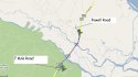
Family members, as well as law enforcement and search groups from North Carolina, South Carolina, Florida and Maine, scoured wooded areas near Powell Road in Georgetown County and Seven Mile Road in Charleston County.
This wasn't the first time volunteers had searched those particular areas in Georgetown, said Monica Caison, director of the Community United Effort Center for Missing Persons in Wilmington, N.C., which conducts nationwide searches for missing people.
"It's always good to go back to places that we've searched prior," she said. "We have to continue to go back and look at areas and make sure we've turned over every stone looking for her."
Read more:
http://www.thesunnews.com/2010/01/10/1253130/dozens-brave-cold-to-continue.html#ixzz0mtH8Vj98
From the beginning, law enforcement agencies and the CUE Center for Missing Persons -- which organizes the large-scale searches -- have dedicated thousands of hours on the search for Drexel.
Their efforts have concentrated largely within a five-mile radius in the North Santee Community where detectives tracked Drexels cell phone signals from the night she disappeared.
Aside from the cell phone clue, detectives and searchers havent found much else. The discovery of a pair of sunglasses resembling a pair worn by Brittanee sparked hope in December, but there has been no confirmation on whether they belong to her.
http://www.carolinalive.com/news/story.aspx?id=399498
There have been many leads and few clues. Monica Caison, the Executive Director of the CUE Center for Missing Persons has been looking for Brittanee since she vanished.
We returned to Seven Mile Road (in McClellanville) because this has always been a point of interest for Brittanees cell phone, she explained. The cadaver dogs are out here to seek out any human remains. We have horse teams because they can see farther ahead over ditch banks and high bushes.
http://www.wciv.com/news/stories/0110/694481.html
Todays search went on in the area where Drexels cell phone gave out its last signal on the night of her disappearance back in April. The search will continue tomorrow.
Caison said there is about a 20 mile area they are continuing to focus on in Charleston County.
http://www2.scnow.com/scp/news/loca...ng_teen_continues_in_charleston_county/96685/
Horses, dogs and about 100 people searched over acres of land near the North Santee River in Georgetown County, South Carolina. But all they found was debris and animal bones. The search was organized by the CUE Center for Missing Persons.
http://www.whec.com/news/stories/S1354177.shtml?cat=566
Another wide-ranging search for missing teen Brittanee Drexel is planned near Georgetown County in South Carolina this Saturday and Sunday, said Monica Caison, who is heading the search. Drexel, a junior at Gates Chili High School, has been missing since April 25. The search will run from early morning until dawn in hopes of scanning some of the areas where Drexels cell phone gave off its last signal.
Weve done at least 12 smaller searches in December and we want to eliminate some sections to make sure there is nothing undiscovered, said Caison. Weve had volunteers sometimes looking for at least four days in row at the end of the year.
http://www.democratandchronicle.com/article/20100105/NEWS01/100105007