Deceased/Not Found WA - Rachael Anderson, 40, Clarkston, 16 April 2010 - #5 *C. Capone guilty*

Any idea if CC had any connections to the Craigmont/Winchester/Cottonwood area? Exploring possibilities of a recurring "267" dream and when I searched milepost 267 in Idaho, came up with this bridge project over Lawyer's Canyon/Creek. Looks like at least a 200ft down below that bridge, and the Google aerial looks like it might be accessible off Hwy 95 from just north of the bridge, but probably only with an ATV??

http://itd.idaho.gov/accountability/US_95_Lawyers_Canyon.htm

One interesting thing...maybe...is that there is an old hwy down in the canyon that goes through there (under that new bridge I believe). I dont remember where you turn exactly to use it...but it is still open.
 
One interesting thing...maybe...is that there is an old hwy down in the canyon that goes through there (under that new bridge I believe). I dont remember where you turn exactly to use it...but it is still open.

So there is no creek or water running under there? Can't really tell from Google earth if that long bugger is dry or an actual river.

TIA

ETA: It looks like you access south of Craigmont by turning west on Evergreen Rd, then immediate left (south) and more or less parallel Hwy 95 until it angles under the highway near the bridge. Road appears to not go much further, and also heavily treed with some rough terrain. If the road does dead end there, how much travel would it get?

About how far down do you think that old highway is below the bridge?

It is a through road....i can't figure out if the line running next to hwy 95 now is old hwy 95 or the railroad itself....and im just not sure about there still being water down there or not....i will have to ask around and see.
 
It is a through road....i can't figure out if the line running next to hwy 95 now is old hwy 95 or the railroad itself....and im just not sure about there still being water down there or not....i will have to ask around and see.

Hwy 95, then old 95, then railroad furthest west. You can see the big trestle when you zoom in far enough, a little north of where the bridge is. So old road east of the trees, RR west of.
 

Attachments

  • Hwy 95 and RR.jpg
    Hwy 95 and RR.jpg
    493.5 KB · Views: 32
This is a wider area map that shows where the bridge is relative to Craigmont, for those who might be out area and not familiar with the lay of the land.
 

Attachments

  • MP 267 ID95 wide shot.jpg
    MP 267 ID95 wide shot.jpg
    499.4 KB · Views: 32
And these are from MP 267 on I-90 in WA, just a little west of Spokane. Halfway between exits 264 and 270, with no direct access from the Interstate to the lakes and areas north and south, but they can be reached from exit 270.

This just shows what is in that area and lines up with the MP marker. Double image is street view of the actual marker and the little man shows where that is relative to the southern tip of Silver Lake.

White X on the second map is right about where that spot is relative to wider landscape.
 

Attachments

  • MP 267 I90 WA both views.jpg
    MP 267 I90 WA both views.jpg
    568 KB · Views: 5
  • MP 267 WA I90 Wide.jpg
    MP 267 WA I90 Wide.jpg
    724.3 KB · Views: 5
This is a wider area map that shows where the bridge is relative to Craigmont, for those who might be out area and not familiar with the lay of the land.

I follow this thread every day in hope of Rachael being found.

Good grief that is some pretty isolated terrain. Are there any landfills along 95? The reason I ask is almost to the right of center it looks like one. Also, certain states allow toxic waste dumps as well that are very far off the beaten path and only guarded at a front gate. The ones I have seen are only fenced by a shabby barb wire fence similar to a cattle fence.

I know, far fetched but just a thought.

It's come up before in one of the earlier threads. Somewhere south of Lewiston I think there is one, but I'm not sure where. Hopefully somebody local will jump on and clarify on that, as I might be dreaming (again!).

Local transfer station is at 560 Downriver Rd in Lewiston, just north of town, on Hwy 128.

http://www.cityoflewiston.org/index.aspx?nid=307

Asotin County landfill is west of Clarkston on Hwy 128.

http://maps.google.com/maps?client=...ocal_result&ct=image&resnum=4&ved=0CB8QnwIwAw

Remote and isolated describes a good chunk of real estate from the Palouse south for quite a ways. I figure about as tough to find Rachael as will be to find Susan Powell. Where do you start?

Wish we knew where CC's haunts were.

There are some things like that around yes....most of them you have to pay to dump..so you drive through...talk to a human...a very good way to get caught if you ask me. Not to mention that around here it would be silly to go someplace like that when you could just go out to the middle of no where and not have to see anyone.
 
Where is Rachael Anderson?
Posted on 30 July 2010


The search for a missing Clarkston woman is far from over. With the help of cadaver dogs, several detectives and ATF agents combed wheat fields, wells and old farmhouses today in rural Whitman County. The goal is to find Rachael Anderson, who has been missing since April 16.


Tribune photographer Kyle Mills and I accompanied the task force on the five-hour search near Colton and Johnson. Asotin County Detective Jackie Nichols (pictured below) was leading the charge, and she is determined to find the 41-year-old mother of four who was last seen in Moscow.
This is the first time I have seen ATF Agents and Whitman County mentioned in a search for Rachael. Hoping this is due to a new lead or maybe the little bastar% is talking to a snitch in jail. Full article to be posted on Saturday.

ETA: Looked at a map and see Pullman and Pomeroy, this area was mentioned early on by LE in searches for Rachael.
 
Would someone with a subscription to the LMTrib please paraphrase the details of the news story on Rachael?
 
Police have named Capone as a person of interest in the case, but no charges have been filed in connection with Anderson's disappearance. Officials said he hasn't been talking to the Rachael Anderson Missing Person Task Force since his attorneys got involved.

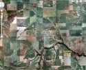
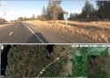
Several members of the task force gathered in Colton Friday morning to begin the latest search for the missing woman. Nichols divided the group into four teams and handed out notebooks with color-coded maps and a list of questions to ask residents in the area, along with photos of Anderson and vehicle descriptions.


"The reason we're searching here is we had a witness who saw a white SUV come out of this area about 4 a.m. on April 17 and turn on to Highway 195," Nichols said. "The witness was going to work and noticed the white vehicle because it didn't stop at a stop sign."

Nichols knocked on the doors of farmhouses, and asked occupants if they saw anything suspicious or unusual around the time of Anderson's disappearance. She asked if they noticed any fresh digging, tire tracks or burn marks. She inquired about abandoned silos, root cellars, ponds or old garbage dumps in the area.


The caravan of unmarked vehicles left a trail of dust participants included four special agents from the Bureau of Alcohol, Tobacco, Firearms and Explosives, Detective James Fry of the Moscow Police Department, Detective Tim Besst of the Latah County Sheriff's Office and two cadaver dogs and their handlers, Ronda Bowser and Doug Huffman of the Clearwater County Sheriff's Search and Rescue dog team.

Word of the search spread quickly among neighbors in the bucolic setting. "Everyone knows we're here," said Darrell Bone, an ATF special agent. "We're rolling up to houses and people are saying, 'I was wondering when you'd get here.' "

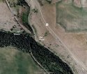
After receiving a command, the cadaver dogs jumped out of a pickup truck and headed to a well at the first stop. Pandora and Kanobi didn't show any indication there was a body in the area, which turned out to be a time-saver for the searchers. Lifting the heavy lid off the well would've required pry bars and lots of manpower. A nearby pond also came up empty.

But the ATF agents are confident Anderson will be found and the case will be solved.


Nichols is also optimistic about finding the Clarkston woman. After hiking through a field to a cistern, the energetic detective was eager to check out another tip from the property owners. There's an old well up the road that could yield some clues.

At the site, the dogs were released, but no scent was found. Phil Druffel, a 73-year-old farmer, stopped by to offer some suggestions. A lifelong resident of the area, he spoke of an old slaughterhouse, a barn and other places that may be of interest. "You're in my prayers," Druffel said as the search continued.

The dogs got back to work at an algae-covered pond with easy access from a main road. "This would be a great place to conceal a body," said Nichols as she walked around the murky green water ringed with neck-high cattails.

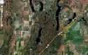
No body or clues were found at the site, but the searchers got another tip from one of the other teams in the area. The caravan headed to the last stop of the day, an old farmhouse at the end of a dirt road filled with ruts. Surrounded by apple trees, the setting is remote and eerie, even in daylight. The cadaver dogs circled the premises, but didn't get any hits.

Nichols was not discouraged. "I really appreciate the fact Sheriff (Ken) Bancroft allows me to dedicate time to this case. I feel good about today's search. We got the information out and it will keep this case in people's minds when they're out working in these fields."

"I don't think people realize it's really hard to hide a body," added Todd Smith, an ATF agent. "They don't stay hidden forever."

Anyone who has information or tips to offer can call Nichols or Capt. Dan Hally of the Asotin County Sheriff's Office at (509) 758-2331.

http://www.lmtribune.com/story/northwest/514068/
 
I think this is the LONGEST article on Rachael as of yet~ And this is even paraphrased! It truly is "about time they showed up"! IMO.

Good to see they are all out there hitting the pavement so to speak! I have been hella busy thanks to Hail season but Rachael is NEVER off of my mind.

Thanks to you ALL for keeping this thread going.

Anyoldtime I sure hope you can figure out that dream. It is very interesting that is for sure.

I have not had dreams about RA in awhile (since I CRASH once I hit that pillow) but I wanted to see what you all think about this.

I have a 3 year old that started having "night terrors" when Rachael went missing. Starting that first night we heard about it. Oddest thing really. She would say some of the WEIRDEST stuff. Someones legs were hurt, or he was after her, "my face hurts" "please don't hurt me like that". Those nights I would have the MOST INTENSE dreams about Rachael. My daughter would wake up with NO IDEA what she went through the night before.

There were nights my husband would be out of town so I would verbally have no one to talk to about Rachael, on those nights my daughter had NO night terrors. On the night we would talk about it, or I would really have my heart and soul into figuring things out ( like intense nights on here ) she would wake up screaming horribly again.

Since we have been so super busy and Rachael gets talked about but mostly in daylight hours my daughter has had NO dreams that she has screamed about. To me I think this is SO odd.

The weirdest thing is that my daughter doesnt KNOW Rachael. Never has met her, has only seen pictures and heard us talking about her. I truly think if I could get in that little girls head she would show me things I need to see.

But there is no doubt in my mind that Rachael is buried IN something. The visions I see of her both freak me out and worry me to death. Wish I could see more specifics also. That seems to be the way they come to us tho.

It is so frustrating!
 
Wow! Finally some details! The white SUV seen on April 17th ...
The tips they are getting from the locals in the area are invaluable!!! Like the older gentleman who lived in the area his whole life, those are the kind of tips LE needs to find Rachael.

Interesting about the dreams ... Look forward to hearing more.
 
OK, word association. Please, don't google, don't overthink, don't tear it apart or numerologize the poor thing. Just whatever either pops into your head, or has meaning and would somehow relate to general Palouse area (do not know how to narrow this down further). Trying to determine the meaning of what I "heard" this morning. And I don't see or hear. Just occasionally dream something with meaning. This was part of a short sentence I heard clear as a bell this morning between smacks of the snooze alarm. Freaked me flat out, as it was sort of like a "Field of Dreams" moment, and one annoying mother clue. Was a man's voice FWIW, and I was not asleep. Not wakey wakey enough to feel like rolling out yet, but awake.

Won't relate whole sentence, but "Patrol 19" was the pointer. Mean anything at all to anybody local? Or should I just file it under "time to see a shrink"?

Absolutely AWESOME to know that LE is out actively searching for Rachael and that tips are still coming in. Normally I'd not get any too excited about a white SUV (they are a dime a dozen), but out in those tiny towns?? Not so much, and the locals would know if it belongs or not.

I wonder if CC was on one of those many side roads and headed back from his dump spot? And which direction onto 195 he was turning. Presumably south, but I didn't catch that in the article.
 
What pops into my head is that the first time I saw Rachael in my dream she was on a dirt "floor" but the number 19 was somewhere behind her. In B&W the sign or background was black, an old black and the white was the numbers, only they were slighty curled sorta "peeled" looking. I have no idea what it means. What it relates to, but I am slightly freaked out that the same number came to you. I so bad want to say its on a old wood barn, but its only as big as a mile marker. And for some reason I have a nagging feeling it could be an address, or a mile marker... or both. Such as a old address marker.....
 
milepost 19 would be very close to Colton, WA.....a little north of there...
 
About 8 miles north of Colton is where it would be I believe (on hwy 195).
 
And these are from MP 267 on I-90 in WA, just a little west of Spokane. Halfway between exits 264 and 270, with no direct access from the Interstate to the lakes and areas north and south, but they can be reached from exit 270.

This just shows what is in that area and lines up with the MP marker. Double image is street view of the actual marker and the little man shows where that is relative to the southern tip of Silver Lake.

White X on the second map is right about where that spot is relative to wider landscape.

Thanks for the maps, it makes it clearer now. The bridge is within the 50 mil radius, I think she will be found in.
 

Staff online

Members online

Online statistics

Members online
140
Guests online
3,312
Total visitors
3,452

Forum statistics

Threads
593,041
Messages
17,980,137
Members
228,996
Latest member
Lag87675
Back
Top