Falling Down
Well-Known Member
- Joined
- Jun 15, 2016
- Messages
- 2,189
- Reaction score
- 12,518
Just a couple of screen shots of the DSS building, one is from a video posted in late 2016 by a YT user, the other is from the day the girls were found. WTHR messed up the wording in the video, the girls weren't missing anymore, they'd been found.
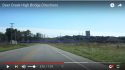
Here's a video from a YT user who walked a considerable distance along the old RR right-of-way, which ends up at the MHB.
At 25:40, he's in the area roughly where BG would have gotten on the trail, assuming he parked at the DSS building parking area. That building no longer stands, it was torn last year. The railroad siding is part of the Andersons grain complex.
25:50, the spot where I believe BG got on the trail, by IN 25 and the Freedom Bridge.
26:20 shows C.R. 300, and the trail which is in the wooded area across the road. This is west of where A&L were dropped off, about 1/8th mile.
JMO