CA CA - Barbara Thomas, 69, from Bullhead City AZ, disappeared in Mojave desert, 12 July 2019 #7

Status
Not open for further replies.
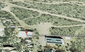
I believe the parking lot is the Providence Mountains State Recreation Area. If you look it up on Google, and look at the photos around there, or just zoom in,you'll see images of the square parking lot (sorry my tech skills are not good enough to post the photos I found, maybe someone else can). Now, where would you need to be, to get a photo that would have that parking lot in it? Not sure. Might validate the theory that the 360 degree photo was taken earlier in the day from another location? Could they have gotten high enough, in a 1 mile walk, to view that side of the mountain from where RT says they were parked? And if a car was parked at that parking lot, how long would it take to get from there to where the RV was? If the photo you are refering to was taken from near where the RV was parked, as it is linked there, maybe it would be possible to see...


So, if you think they were actually some 20 miles east of where RT said they were, that's interesting. Sure, then the parking lot would be visible.

That means RT almost certainly took an unimproved road to where he parked the RV and called the police. There would have been a good sized dust plume as he drove along the route - so people at Providence that day may have seen it. No difficult climbs to make, just a gentle walk up to the top of a hill (which sounds about right for the geriatric set).

It would be very interesting if LE took dogs and cadaver dogs out to that area. Or interested volunteers.

I figure it would take 50 minutes to an hour to get to where the RV was parked, given the washboard nature of the roads.

Surely LE can tell the difference between a pic of that parking lot and the parking lot closer to where the RV was parked. This makes me hopeful that something may happen in this case. Unfortunately, so far, the info we have is that RT was able to provide evidence that Barbara was alive at the Hidden Hills/Kelbaker location (near the Granite Hills). OTOH, if he used an earlier-taken picture to divert police...I hope the police catch that detail.

The Providence area is much more visited, so the chances of someone coming across a body are higher, IMO. But it is a big deviation from where RT said he was, and so if the picture with the cars turns out to be over there, LE needs to search over there.
 
You mentioned Joshua Tree.
If memory serves, Joshua Tree is where Erin Corwin was murdered and her body thrown down an abandoned mine shaft.
It sounds like you're pretty familiar with that area from your time in the military.

For those of us who've never been there, can you please explain the differences b/t Joshua Tree and the area of the Mohave where Barb went missing, i.e., why you view it as being highly unlikely for her to have gotten lost in that location?

TIA!

She was found outside the park.

She was found between 29 Palms and Palm Springs, IIRC.

What's the difference between JT (a national park) and MNPreserve? LE is one thing. Joshua Tree has federal employees who cover the entire park, trying to curtail vandalism. It has several campgrounds, some with reservations. It's a National Park. National Parks are by their very nature quite different from Preserves (which lack 24 hour services, allow people to do various things not allowed in National Parks, etc).

Joshua Tree is a NPark for a reason. It has many amazing things to visit and over 2,500,000 people visited it in 2018. That's way, way more than get out of the car in Mojave NP (many of whom aren't actually tourists). You're supposed to pay a fee to get into Joshua Tree. While it seems deserted, 2.5M visitors means you're never completely alone.

Mojave NP? Many people drive through, few people stop. No entry fees or kiosks. No large federal presence. People go out there to shoot (it's not exactly allowed, but..no enforcement, there's definitely enforcement in JT). They also go out there to rock hunt (not allowed in JT), and so on.

JT has some real hot spots, but in general, isn't as hot as parts of the Mojave NP. The place where Barbara disappeared (or RT says she disappeared) is about the same as most of JT, though. JT is mostly at about 4000 feet, Mojave goes down as low as 1000 feet (so, more like DV).

If you read SBCS's missing person pages, you'll find some reason to believe that people can be searched for and not found (the Amboy couple - he was found 3 weeks after he went missing, his wife was found 11 months later). The DV Germans were eventually found (years after they went missing? after a huge search?)

There's an unidentified skeleton at GC. Clearly was found, but was missing so long, no one longer had any clue who it could be. The skeleton's picture is the cover photo for Death in Grand Canyon. There are still people missing in GC, but eventually, they may be found.

Lots and lots of people go missing in the desert, only to be found quite a bit later. It's harder than some here seem to think to find people out there. For one thing, the searchers themselves are working in very difficult, mind-altering situations. You can definitely try walking around for hours in 105F and see how it goes for you. Water makes no difference. Your body temp will eventually go up a little. At 110F, the NPark people tell you that 30 minutes is about the limit. Local conditions (color of rocks, direction you are walking) play a role.
 
Well there are parts that are similar, and my experience was a short miserable hike, where I did nothing but complain.

The important thing is to focus on where she was, how far she was traveling, and the visibility/reference markers.

Even if she tried to get lost, I just can’t imagine no sign of her being found.

BBM:

Frankly, I can't even imagine Barb getting lost, much less no sign of her being found.

For the sake of argument, though, let's just assume all that we've been told is true.

Here's what can be inferred from RT's account:

Barb was headed off in the right direction when she and RT parted ways, as evidenced by the fact that RT didn't call out and redirect her when she "rounded the corner" or however he put it.

Presumably, if she'd been walking in the wrong direction to get back to the RV, he would have alerted her.

So, Barb was in fact walking toward the RV when RT lost sight of her.

This means she was oriented to where the RV was in relation to her location.

Barb wasn't lost.

JMO.
 
No reason to assume they didn't follow the little trail to:

34.786528, -115.641111

You can see the trail (which is about a mile from where the RV is said to have been parked). It's a less strenuous climb than the hills that are closer to the road - but not much more of a walk to get to. I know which ones I'd be climbing and it wouldn't be the taller ones, it'd be the southern extension of the Granite Hills.

The Sweeney Center's parking lot is not at the top of the hill that abuts it, but at the bottom (and there's another parking lot next to it, which looks like it might be County Maintenance, it would have vehicles).

At any rate, it's very hard to explain any parking lot being seen from along their hike trajectory if that's not the hill they climbed. Or from a point nearby that location (perhaps a bit north, where the first trail goes into the hills). It's almost certain they didn't try getting through the ravine with the black rocks.

If I drop a marker right in the parking lot area (for either the Sweeney Center, the road to it, or the parking area just northeast of it), I get a height of 1780 feet above sea level for the parking lot.

We really don't know which of those hills they climbed, but if they were seeing a square parking lot, where else could it be?

And you're right, we don't know where the 360 was taken (but hopefully LE has some idea). It would be great to know where that other place was.

Hi @10ofRods, thanks for looking into this. I agree that they could've gone up the small rocky mountains you mention. However, it seems quite a bit more difficult than the walk to the outcropping -- more of a climb than I think they would've done. It's around a mile to the base of the mountains and then one would have to ascend around 600 feet of gain in a third of a mile, for a total gain of 700 feet. Not that that's such a huge amount of gain, but it's mostly concentrated into a short distance, which would've been challenging as the day heated up. Also, when I zoom in it in Google Earth, it looks like rock scrambling would be involved. Are you familiar with the trail -- does one of the branches go around the boulders?

If I was RT and said I'd done that, I'd say they'd climbed a mountain. On the other hand, it's definitely possible that climbing some sort of hill or small mountain would take up some of the unaccounted-for time in the day.

Also, I'm confused by a couple of points.

I've attached a screen shot of what I understand to be the two parking lots near the Sweeney Granite Mountains Desert Study Center. On Google Earth, the one in the center of the screen shot (with the two cars) is approximately 4288 feet in elevation. The one to the left is around 4294 feet in elevation. Is there a third lot that I haven't found?? There is a large dirt turnout near the beginning of those trails, with swirling tire tracks. Is that what you mean? Also, by what method was the figure of 1780 feet of elevation arrived at? I don't find elevations that low in that area, but maybe I'm missing something.

Also, I don't remember RT specifying that it was a square parking lot, but maybe I missed that.

I wish LE would just release the 360 photo -- then we'd be able to figure out where it was. ;)

Thanks, and JMO.
 

Attachments

  • Screen Shot 2019-08-19 at 4.58.51 PM.png
    Screen Shot 2019-08-19 at 4.58.51 PM.png
    565.8 KB · Views: 55
Last edited:
That was a great map @ChuckMaureen created. Even if BT had gotten off the trail leading back to the trailer (but I don't see how that's possible). If she veered right she would encounter the power line access, left she could have followed the wash. IMO it would be virtually impossible to get lost out there. Not even accounting for the noise a car passing would have made. If there was a parking lot full of cars, there was surely traffic on the road. @sroads said there was a car every few minutes when he was out there and you could hear them passing from 1/2 mile in on the trail.

Back to square one, AGAIN. None of the details provided in this case make sense unless it was a straight up alien abduction.

Every reason you listed could be why RT thought she had been kidnapped.
 
Hmm, here’s a case from 2008 where a 67-year old woman went missing from “the Piute Canyon area in the Mojave National Preserve”. She was not found.

Similarities: Maria of this report was not caring food or water (well, BT had beer, I guess..), and Maria and her companion separated from each other while trying to get back to their vehicle.

Maria’s case did not seem to get much publicity, it seems, compared to Barbara’s. So, not many details to know if hers was suspicious or not (though I note the companion didn’t report until the next day. Hmm). I didn’t see any updates to this, but she is on NamUs.

But, anyway, just showing that something similar has happened in the area before!

vvdailypress.com
The National Missing and Unidentified Persons System (NamUs)
This is starting to sound like the Bermuda Triangle! : 0
 
Tire Tracks at Turnout, Showing RT "Left and Returned'?
(Parsing Alert)
Police would've known from the tire tracks if RT had left and returned....
@deugirtni Thx for you post. snipped for focus.
How often does LE detect useful tire marks/tracks w sufficient definition/resolution, thru photos or casts, to identify and match to particular vehicle’s tires? In CSI TV, all the time, every time. IRL-CSI, not so often, as it depends on multiple factors, not just a pair of eyeballs glancing at the ground. Not that they all apply here, but factors include:
- Road surface: pavement, concrete, asphalt, gravel, chip-seal, cobblestone, etc.
- Off-road ground surface: sand, clay, caliche, topsoil, ground-cover plants, pebbles, gravel, etc.
- Tire tread pattern(s).
- Weather, wind, precipitation.


LE knows RT's truck & 5th wheel were at turnout, because LE was there when truck & 5'er were at that site. IIUC and AFAIK, on first day initially LE would have had a no reason to be concerned w tire tracks. Later that day, LE may or may not have looked for or detected that "first set" of tracks.


1) Is OP saying: It's a certainty LE did see/detect 'first set', those of RT? If LE tried to make a forensic match– by photo and/or cast – for ‘first set’ of tracks, they may not have been able to.

2) Is OP saying: It's a certainty LE saw/detected "second set' w sufficient definition/resolution to identify and match? If so, respectfully disagreeing w > LE would know if RT "left and returned." < bbm Jmo, not necessarily.
Seems like common sense - if truck & 5'er had previously been there that day and returned, there should be two sets of tracks from those tires. However ----


Could RT have left second set without leaving the turnout? I think so. Drivers who have towed 5'ers or trailers know that they don't always hit the targeted parking space on the first shot, even a huuuuuuuge space. [:rolleyes:Anyone not fessing up has a hand behind the back w fingers crossed. Fibber :rolleyes: ]. Esp'ly w new equipment (wasn't this trip the maiden voyage for RT w this truck & rig?), drivers often make several attempts before hitting the bull’s eye. When initially pulling off highway into turnout, RT could have driven back & forth multiple times - two, three, four – to align the vehicles in a certain way, for ex. to orient for more shade on one side or end of 5'er.

So, imo, LE could have found & matched two sets of identical impressions, suggesting RT left, although he may not actually driven from turnout.


Alternatively, RT could have left turnout by driving truck, with or without 5th wheel, and left tracks which either---
- LE could have seen/detected and identified as his, or
- LE were unable to identify as his.
^jmo.


TL, DR? Better not to assume what LE knows or does not know. jmo
 
Lots and lots of people go missing in the desert, only to be found quite a bit later. It's harder than some here seem to think to find people out there. For one thing, the searchers themselves are working in very difficult, mind-altering situations. You can definitely try walking around for hours in 105F and see how it goes for you. \
Respectfully snipped for commentary focus.
THANK YOU. This is what I've been trying to emphasize, but you said it much better. I really do believe Barb is out there, waiting to be brought home.

Amateur opinion and speculation
 
No reason to assume they didn't follow the little trail to:

34.786528, -115.641111

You can see the trail (which is about a mile from where the RV is said to have been parked). It's a less strenuous climb than the hills that are closer to the road - but not much more of a walk to get to. I know which ones I'd be climbing and it wouldn't be the taller ones, it'd be the southern extension of the Granite Hills.

The Sweeney Center's parking lot is not at the top of the hill that abuts it, but at the bottom (and there's another parking lot next to it, which looks like it might be County Maintenance, it would have vehicles).

At any rate, it's very hard to explain any parking lot being seen from along their hike trajectory if that's not the hill they climbed. Or from a point nearby that location (perhaps a bit north, where the first trail goes into the hills). It's almost certain they didn't try getting through the ravine with the black rocks.

If I drop a marker right in the parking lot area (for either the Sweeney Center, the road to it, or the parking area just northeast of it), I get a height of 1780 feet above sea level for the parking lot.

We really don't know which of those hills they climbed, but if they were seeing a square parking lot, where else could it be?

And you're right, we don't know where the 360 was taken (but hopefully LE has some idea). It would be great to know where that other place was.
What about Primitive Campsite just to the North- it has a parking area next to the hills.

Google Maps
 
BBM:

Frankly, I can't even imagine Barb getting lost, much less no sign of her being found.

For the sake of argument, though, let's just assume all that we've been told is true.

Here's what can be inferred from RT's account:

Barb was headed off in the right direction when she and RT parted ways, as evidenced by the fact that RT didn't call out and redirect her when she "rounded the corner" or however he put it.

Presumably, if she'd been walking in the wrong direction to get back to the RV, he would have alerted her.

So, Barb was in fact walking toward the RV when RT lost sight of her.

This means she was oriented to where the RV was in relation to her location.

Barb wasn't lost.

JMO.
Easy to get lost AND stay on a trail- Remember that she had been drinking, perhaps more than one, it was blazing hot, she was in a hurry perhaps why she went ahead, no way you could see the RV from that turn.... She only needed to make one tiny mistake at the junction of those trails and bingo, she's lost.

upload_2019-8-19_21-42-5.png
 
Easy to get lost AND stay on a trail- Remember that she had been drinking, perhaps more than one, it was blazing hot, she was in a hurry perhaps why she went ahead, no way you could see the RV from that turn.... She only needed to make one tiny mistake at the junction of those trails and bingo, she's lost.

View attachment 199266
^ this.. I know when you get disoriented you want to start moving faster, you still have strength, not too thirsty yet, you know it's not far. You hurry..panic begins to nip. It's hotter than hell.
Barbara could still be there..except for the theories that are a difficult reconcile.
 
Last edited:
Do they have RTs footprints? To show he actually walked the path? Do they have Barbara's footprints anywhere? If you passed the spot RT made his report at how far up the main road is the next entrance?
 
Do they have RTs footprints? To show he actually walked the path? Do they have Barbara's footprints anywhere? If you passed the spot RT made his report at how far up the main road is the next entrance?
That's what I have wanted to know. Especially since the RV and truck was parked where it was. There has to be an area there with their foot prints, right?
 
Status
Not open for further replies.

Members online

Online statistics

Members online
175
Guests online
4,160
Total visitors
4,335

Forum statistics

Threads
592,606
Messages
17,971,648
Members
228,840
Latest member
WhatHappenedToJAB
Back
Top