Found Deceased CA - Kiely Rodni, 16, missing from a large party @ Prosser Family Campground, car not found, Truckee, 6 Aug 2022

Status
Not open for further replies.
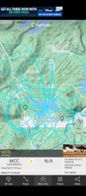
Agreed. I’m just not used to seeing the big loops used here for infrared…
I was wondering - having absolutely no experience or knowledge on this subject - do specific aircraft have infrared capabilities ? Or certain flight paths indicate a type of technology they may be using ? Would love to learn more about it.
 
I was talking to my neighbor after my run… on Sat morning he went stand up paddling from the boat launch. When he got there 9am, there was a kind of a rundown truck stuck in the mud next the boat ramp with no license plates, NRA stickers etc. I asked if he reported it and he hadn’t…. He figured people already reported it. I told him to report it anyway….
A truck with no license plates. I wonder if the license plates could have ended up on a silver Honda CRV? Would certainly have made it harder to find before now. JMO
 
Just catching up with this case. I’m assuming with that many people at the party, there would surely be many vehicles there too?

I was just wondering if she was highly intoxicated, wouldn’t it be difficult to maneuver out of that situation. Also, maybe someone had to move some vehicles to even let her get out. Yet, no one has come forward with when she actually left and no one knows exactly how she left?

I’m leaning toward this being a terrible accident, but I suppose anything is possible. I’ve been wrong before on these cases. I just hope they find her soon.
I have been thinking about the moving of vehicles too!
 
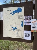
If you expand this depth map of Prosser Reservoir, the depth seems to be 31 ft at the end of the boat ramp and 51 feet just a little further out, assuming I’m interpreting this correctly. Of course, with drought conditions all bets are off.

 
If they are doing extensive flights over the terrain in a grid like pattern does that mean the search of the lake and boat ramp had no findings? I wouldn't think they would go to the expense if they had found something in the lake. But it's just a thought. ???Screenshot_20220809-221600.png
 
I was wondering - having absolutely no experience or knowledge on this subject - do specific aircraft have infrared capabilities ? Or certain flight paths indicate a type of technology they may be using ? Would love to learn more about it.
Like sonar? Training exercise? Looking for headlights or movement? I know nothing about this type of thing? We need an expert to let us know?
 
The Beech C12 Huron aircraft military models are equipped with surface search radar according to this website regarding military equipment C-12 Huron Military Passenger and Transport
I think some have also been modified to have infrared sensors. Regardless, I’m hoping they are successful tonight whatever the mission is! Headed offline, but hoping for good news for Kiely.
 
Went on my run and basically did a quick tour of where some of these sites are. Beautiful 6 mile run.... basically my backyard.

This is where the kids were camping. There were fire scars in the dirt. I don't know if was from them?!?View attachment 358731View attachment 358732
View attachment 358730

This one of the dirt roads to get to the campsite
View attachment 358733


For reference, this is the Family Campground

View attachment 358734

This the access to the boat ramp.

View attachment 358735

View attachment 358736

Views of the Water from the boat Ramp area

View attachment 358737

View attachment 358737

View attachment 358738


Finally the view of Prosser before I enter back into my hood

View attachment 358729

Thank you for taking these photos and sharing them with us and for the extremely useful information about the location. The scenery is stunning, it looks like a great place to live near and go for a run in. Are there no signs or anything to warn people of the danger that they are approaching deep water near the boat ramp? I’m wondering how visible the water is at night and how deep the reservoir is. The information online says the reservoir is man made and 163ft in height so the water would be 49 meters if it was at maximum capacity.
 
Thank you for taking these photos and sharing them with us and for the extremely useful information about the location. The scenery is stunning, it looks like a great place to live near and go for a run in. Are there no signs or anything to warn people of the danger that they are approaching deep water near the boat ramp? I’m wondering how visible the water is at night and how deep the reservoir is. The information online says the reservoir is man made and 163ft in height so the water would be 49 meters if it was at maximum capacity.
In one of the approach pictures to the boat ramp, you can see a sign on the left. The road descends for quite a while to the waters edge. I’ve been there at night, so it is long enough that you notice going downhill for a bit.

I was talking to my neighbor about how deep it is out by the boat ramp, an honestly we are not sure. I think the deepest part of Prosser is closer to the damn, but my neighbor does think it drops off more than we think near the boat ramp.

Interestingly there was a very slight breeze tonight… and I definitely noticed the water currents pushing to the right of the boat ramp as you face the water. Friday night on my deck, I did not notice any significant breeze so I would think Prosser was also fairly calm that evening.

I can still hear the plane…. And I have a 6:30am call with my team in Hyderabad, India…. Argh!
 
Last edited:
I have a dumb question that someone might be able to answer for me. The ability to read license plates exists…I know because I pay my tolls that way and I’ve had friends get tickets that way…so why is this not used in cases like this? Is it not as simple as I’m making it in my head? Is it not possible to check and see if that license plate was captured in the surrounding area at least? Please educate me if you have any knowledge regarding this. Thanks!
 
I have a dumb question that someone might be able to answer for me. The ability to read license plates exists…I know because I pay my tolls that way and I’ve had friends get tickets that way…so why is this not used in cases like this? Is it not as simple as I’m making it in my head? Is it not possible to check and see if that license plate was captured in the surrounding area at least? Please educate me if you have any knowledge regarding this. Thanks!
I am in LA/Southern California, and we do not have any tolls in our area, so I'm thinking NorCal is similar.
I am familiar with EZ Pass and the like in other states.
 
Status
Not open for further replies.

Members online

Online statistics

Members online
178
Guests online
4,450
Total visitors
4,628

Forum statistics

Threads
592,485
Messages
17,969,529
Members
228,783
Latest member
Smokylotus
Back
Top