Australia Australia - Theo Hayez, 18, Belgian backpacker, Byron Bay, June 2019

Status
Not open for further replies.
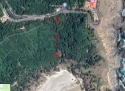
I have spent hours looking at the maps, it seems he headed into the scrub away from the beach then changed mind and headed back, according to the News Corp map, I can see a goat track in google maps though this seems somewhat further from the last phone ping mark, if accurate he walked in what appears a slight loop along the very end of the beach, but was not yet into the rocky area. It was low tide, just starting to come in (correct me if I am wrong). So if tide was low and in the area of the last ping (am or pm?) , could he have fell over or dropped his phone in the water? Would the water have been that far, to where the pings ended? Is it possible he was followed by someone and separated from his phone if in a scuffle? Phone perhaps thrown in the water? If the hat that has been found is Theo's then why was it 200 meters away from the beach? Again only relying on information which may or may not be accurate but why leave hat behind on a cold night? It is possible he fell, slipped, hit his head earlier? Disoriented? If someone has hurt him then could be possible to make it look the way it does. I don't wish to say it, but did he walk that last bit near the beach or did someone else have his phone? When he walked into that scrubby area away from the beach was it with intention of finding a way to the lighthouse? Was he alone? Was he followed? We don't know. Now if someone sinister followed him or met with him, IF anything bad happened well the ocean is just there and from what I read strong currents out past the rocks. It could very well be made to look like an accidental drowning yet not be so. I really don't like suggesting this, am hoping for a miracle and yes it is possible he was kidnapped, stranger things have happened. It would be a better scenario if so as gives hope of finding him alive. The phone and Theo may have parted at this point of the last ping, but it is not necessarily where Theo's journey ended. I truly hope not. If he was abducted then I imagine the phone would have been disposed of there and then, perhaps thrown in the water there and then. I do hope he did not attempt to climb the goat track where that boy fell from. It would have been dangerous especially at night and there was no moon, so question is was he likely to try the track with no light? Logic says unlikely though I do not know how this track even looks like from close. Perhaps it seemed maneuverable but how he could even see ? How long would a phone light last for? He seems to have made it a long way in the dark already. And if his phone pinged next day at 1.42 pm (IF this is correct) then it confuses even more, along with a hat that is 200 meters away from the beach. Looking at the distance bars on google map he did not venture this far in, maybe 50 meters but not 200. If police had all this information, his route then there are reasons they did not release it. If they believed it was an accidental drowning, as per this route information why the focus on finding his phone? Belgian police? There is much more to this, and like it was said nothing can be ruled out. If Theo was in company I believe the police will get to the bottom of this. They can check other mobile phones in the area, most likely know a lot more yet that has not been released. I was doubtful of that hat being Theo's but if this route he took is right then high chances too this hat, but is his though strange police did not find it. I did read about a case of a missing person in Canada however, unfortunately a sad ending but the body was only 3 kms away and it was missed for 7 years I believe until found accidentally during a search exercise drill. So is possible they missed the hat. So glad good people out there are searching and I feel persistence will pay off and perhaps already has, if this hat is his. Long thoughts here, so long write up. I feel though very much we are getting closer. I have not stopped thinking about Theo and his family from the very beginning, every day, every night and is frustrating not being able to help but knowing so many others are out there searching really gives hope.
 
I think police have more info they aren't releasing and are playing a waiting game for someone to slip up and mention something that only a perpetrator would know. The case near me is like that. They haven't released particular details about the woman's death although I think I figured some of it out because I live nearby and have seen and know what goes on in the area. Locals who know the BB streets and foreshore area well should put their thinking caps on. What dodgy or strange things go on there that anyone may have experienced? Especially in recent times (and I don't mean aboriginal tribes living in the bushes!)
 
I'm a little bit out of the loop as I haven't read much on this case recently, but this is new to me:
View attachment 193966
The path he took from Cheeky Monkeys to the Cape.

If we look at this in Satelite google maps...

The map of Theos path:

Left onto Kingsley then left on to Tennyson, Appears that he went all the way to the end of Tennyson which is a dead end street. There is busland at the end of the street.

He then turns back and comes back along Tennyson in the direction he first came from. There is a large sports / recreation field on the left as he walks straight towards Kingsley Street.

He gets about 3/4 the way passed the recreational centre / sports field and then turns left and takes a short cut through the sports field when there is a bike path / waking path only metres away and heads straight towards Cowper St.

He gets to teh end of the recreation field turns right onto Cowper, walks a shrt distance and then is seen to turn right, possibly onto the bike path between the recreational centre and the scout hall / tennis coarts direction. He doesnt walk far and then turns left veering off the bike path and walking at an angle on the the grass twards the corner of Cowper and Carlyle,

He then gets to Carlyle and turns sharp left up Cowper st veering to the right until meets Marvell street where he turns right.

He walks along Marvell St till he gets to the end and then turns right onto Massinger St,

He then turns left onto Short St and then right onto Patterson St,

He then turns left into Milne St and commences the walk on Milne walking track. He doesnt appear to follow Milne track instead continuing straight and towards Tallow Beach rd when Milne diverts to the right. I can see some from of a track that appears to then stop in the bush however ths track is not named.

I would say he then goes through the bush and heads to Tallow beach road where he turns right and follows this along to the car park where the loop is on the map and he exists onto the beach after the second track shown from car park.I saw he exited on that second track exit from carpark to beach as the weird loop shows on the route map, it to me appears it is him circling car park and taking that second exit to beach going clockwise.

He then turns left and walks to the end of Tallow beach where it appears that he climbs up to the left towards the bush before the end the beach and then goes back down again to the end of the sand (or his phone did)

This is all based on the map of where he walked in the article and only my estimates.
 
Last edited:
Just a few lines from the Daily tele article as not sure they have been printed in other outlets.

By Mark Morri and Jane Hansen

A Baseball cap similar to that worn by missing Belgian backpacker Theo Hayez has been found in Byron Bay at almost the exact spot the last known ping from his mobile was recorded.

It then goes on to advise that it was ten days ago and is being tested by NSW police to see if it provides any matches with the missing 18 year old.

Within hours of the search a volunteer saw a dark cap which was slightly frayed and had the puma logo described by his friends as similar to the one he was wearing when he went missing.

One search member sent a picture to Theos cousin Lisa Hayez who thought it was her missing relatives cap.

Police took possession of it and a local detective said that they would run exhaustive tests to confirm if it belonged to the backpacker.

It was found in scrubland near a large homeless camp 200m from the beach.

The Daily Telegraph has obtained Theos final phone records showing the route he took from Cheecky Monkeys about 11pm until just after 1am the next morning when the last recorded signal came from a tower near Cape Byron lighthouse.
 
The Daily Telegraph reported hat was found 200 meters from the beach however there is a new post on Theo's page now which says it was 50 metres in at the end of Tallows beach, which corresponds with the area where he headed into the scrub according to his movement tracking map. His parents were present during the search and I think this information is therefore accurate as well as this area where hat was found matching the map of his/his phone's travels.
 
I’ve thought about that too, that’s he’s been invited to another party. It was a Friday night, so lots of options. I’ve never done any drugs before, but once at a party, been drinking fair bit of wine, then offered a 1/4 hash brownie and though yea, I’m with small group and safe, so try just once to know what it’s like. Subsequently began to feel paranoid that grew and grew, that the hosts drugged me to rape me, was calling 000 t help me, locked myself in a bedroom pushing furniture behind door, partner finally came to take me home, even thought he was in on it, started thinking about suiciding. Urine drug test next day showed heroine. Assume hash that was used to make cookies was laced. Either that or had drink spiked. Happened to Gary Tweddle, found at bottom of cliff after 6 weeks. He had drunk one to two bottles of wine and then took cocaine. Was last seen running out of his hotel

I came across this tonight you may be interested in. Quite interesting actually.

https://narratively.com/the-roaming-beach-kids-of-byron-bay/
The Roaming Beach Kids of Byron Bay

Story by Anna James · Photos by Rudiger Wasser · 1.11.16
Share:
The gypsy kids’ campground would be beautiful, if not for the debris. A baked bean can, water bottle, and a dog bowl are scattered on the dirt amongst three deflated tents and piles of soiled blankets. There’s a pink massage claw, a tabloid magazine and liquor bottles.

The squatter camps like this one in the hinterland surrounding Byron Bay are illegal, but easy to find; behind the main strip, Jonson Street, walk a few meters inland, and tents appear. Neon-green, foliage-topped rosewood trees join baby blue sky; the salty summer air steadies on ninety by noon. Waves tumble nearby.
 
If we look at this in Satelite google maps...

The map of Theos path:

Left onto Kingsley then left on to Tennyson, Appears that he went all the way to the end of Tennyson which is a dead end street. There is busland at the end of the street.

He then turns back and comes back along Tennyson in the direction he first came from. There is a large sports / recreation field on the left as he walks straight towards Kingsley Street.

He gets about 3/4 the way passed the recreational centre / sports field and then turns left and takes a short cut through the sports field when there is a bike path / waking path only metres away and heads straight towards Cowper St.

He gets to teh end of the recreation field turns right onto Cowper, walks a shrt distance and then is seen to turn right, possibly onto the bike path between the recreational centre and the scout hall / tennis coarts direction. He doesnt walk far and then turns left veering off the bike path and walking at an angle on the the grass twards the corner of Cowper and Carlyle,

He then gets to Carlyle and turns sharp left up Cowper st veering to the right until meets Marvell street where he turns right.

He walks along Marvell St till he gets to the end and then turns right onto Massinger St,

He then turns left onto Short St and then right onto Patterson St,

He then turns left into Milne St and commences the walk on Milne walking track. He doesnt appear to follow Milne track instead continuing straight and towards Tallow Beach rd when Milne diverts to the right. I can see some from of a track that appears to then stop in the bush however ths track is not named.

I would say he then goes through the bush and heads to Tallow beach road where he turns right and follows this along to the car park where the loop is on the map and he exists onto the beach after the second track shown from car park.I saw he exited on that second track exit from carpark to beach as the weird loop shows on the route map, it to me appears it is him circling car park and taking that second exit to beach going clockwise.

He then turns left and walks to the end of Tallow beach where it appears that he climbs up to the left towards the bush before the end the beach and then goes back down again to the end of the sand (or his phone did)

This is all based on the map of where he walked in the article and only my estimates.
I have been tracing the route on Google Maps too. Maybe I will upload them later.

Re where the cap was found 50m from the beach... Well not really that close to a homeless camp then?

I am thinking of a possibility. The route must have been mapped by a location app, since it is so precise. Google or Facebook perhaps, and that required use of GPS.

Once the phone went into water, where the last spot was located, GPS would no longer work AFAIK. So there the route ended.

However IIRC the Oppo was water resistant? So it might still ping the phone towers for hours more, until it went out of power.

As for Theo himself.... It didn't look like he was partying, looking at that route. Spark may be right, he was exploring. He might be able to see the lighthouse from Cosy Corner. That was some light, because the route past Patterson St must be very dark. But he couldn't climb up there. He lost his cap while he tried, apparently.

Then somehow, his phone went back down the beach, and finally, possibly, into the water.

Honestly I am feeling pretty bad about it now. Nothing good could have come out of that situation, that I can think of.:(

Someone please tell me I am wrong.

I read up about the gps software on that model it was very advanced. I’ll find it and reply tomorrow ;)
 
I came across this tonight you may be interested in. Quite interesting actually.

https://narratively.com/the-roaming-beach-kids-of-byron-bay/
The Roaming Beach Kids of Byron Bay

Story by Anna James · Photos by Rudiger Wasser · 1.11.16
Share:
The gypsy kids’ campground would be beautiful, if not for the debris. A baked bean can, water bottle, and a dog bowl are scattered on the dirt amongst three deflated tents and piles of soiled blankets. There’s a pink massage claw, a tabloid magazine and liquor bottles.

The squatter camps like this one in the hinterland surrounding Byron Bay are illegal, but easy to find; behind the main strip, Jonson Street, walk a few meters inland, and tents appear. Neon-green, foliage-topped rosewood trees join baby blue sky; the salty summer air steadies on ninety by noon. Waves tumble nearby.
Thanks mussopossum! That’s a fascinating read. Certainly a more attractive option than under the railway overpass in Woolloomooloo!
 
I have been tracing the route on Google Maps too. Maybe I will upload them later.

Re where the cap was found 50m from the beach... Well not really that close to a homeless camp then?

I am thinking of a possibility. The route must have been mapped by a location app, since it is so precise. Google or Facebook perhaps, and that required use of GPS.

Once the phone went into water, where the last spot was located, GPS would no longer work AFAIK. So there the route ended.

However IIRC the Oppo was water resistant? So it might still ping the phone towers for hours more, until it went out of power.

As for Theo himself.... It didn't look like he was partying, looking at that route. Spark may be right, he was exploring. He might be able to see the lighthouse from Cosy Corner. That was some light, because the route past Patterson St must be very dark. But he couldn't climb up there. He lost his cap while he tried, apparently.

Then somehow, his phone went back down the beach, and finally, possibly, into the water.

Honestly I am feeling pretty bad about it now. Nothing good could have come out of that situation, that I can think of.:(

Someone please tell me I am wrong.
Now I’m thinking he did arrange to buy drugs at the Tallow Beach Carpark (using WhatApp - favourite choice of App for buying drugs due to end to end encryption and their non-disclosure policies). Maybe meetup place for homeless campers to interact with buyers? Can probably see the lighthouse from section of beach when walking down from the carpark, but you can’t see lighthouse from Cosy Corner. It’s really steep there and is called Cosy Corner because it’s the only place to go for a swim or sunbake when north or westerly winds are strong causing rough surf and sand blowing in your eyes on the main beaches. So it’s either alcohol, mixed with drugs and going psychotic, possibly died in the bushes or sea (plenty of drug deaths at rave parties). Not sure about kidnapping/Ivan Milat scenario and still think the other two guys at PM just got caught in a rip. Re mobile phone, recently used apps like Google Maps/Facebook can be ‘allowed’ to track your location via GPS-satellite (not cellular towers) in the background even when not open on the screen. Maybe Google Or Facebook handed the route to police, who report back to the government, who in turn report/leak to their superiors -News Corp. So possible Theo’s waterproof phone was last pinging (to Google/Facebook via satellite), in the sea until battery died. I still think the timing of his movements and the timing of low tide is significant. Could take police yrs to charge someone for dealing him drugs without having his phone or body for evidence. Not sure I can follow this forum for that longo_O
 
Last edited:
Now I’m thinking he did arrange to buy drugs at the Tallow Beach Carpark. Can probably see the lighthouse from section of beach when walking down from the carpark, but you can’t see lighthouse from Cosy Corner. It’s really steep there and is called Cosy Corner because it’s the only place to go for a swim or sunbake when north or westerly winds are strong causing rough surf and sand blowing in your eyes on the main beaches. So it’s either alcohol, mixed with drugs and going psychotic, possibly died in the bushes or sea (plenty of drug deaths at rave parties). Not sure about kidnapping/Ivan Milat scenario and still think the other two guys at PM just got caught in a rip
But if he used Google's directions from Tennyson to Tallow Beach car park, he wouldn't be using that route, or had to change directions a few times. A strange route to go to a destination, if there was one.
 
Now I’m thinking he did arrange to buy drugs at the Tallow Beach Carpark. Can probably see the lighthouse from section of beach when walking down from the carpark, but you can’t see lighthouse from Cosy Corner. It’s really steep there and is called Cosy Corner because it’s the only place to go for a swim or sunbake when north or westerly winds are strong causing rough surf and sand blowing in your eyes on the main beaches. So it’s either alcohol, mixed with drugs and going psychotic, possibly died in the bushes or sea (plenty of drug deaths at rave parties). Not sure about kidnapping/Ivan Milat scenario and still think the other two guys at PM just got caught in a rip
I tend to agree with this scenario. But I didn't want to say it earlier. The carpark likely an area where you buy drugs. Psychosis or could have stopped breathing and someone then hidden him.
 
Very possibly he may have been in company so drugs may have been involved if others brought some however Theo had no cash on him according to his friend whom he went to Cheeky's with so he would not be able to buy any. I think the route goes through that car park anyway by the looks of the map, he seems to have walked right around it before going onto the beach, not taking the closest exit but it would have been dark to see. He made no withdrawals and had no cash at the pub and I believe he was said to have used a card to purchase his two drinks so be very hard to be buying drugs. He is said not to be a drug user nor heavy drinker though yes things can change. The way he backtracked in a few places along the town route makes me think he was meeting someone. There are many holiday accommodation places en route and one where he walks to, then walks away from. At the end of the triangle on the map of his route is some villas holiday accommodation. Maybe he met someone then they walked together? Just a guess but a possible one as sources say he used google maps frequently so unlikely to be lost,unless of course he was just checking out the town, deciding to walk random.
 
I came across this tonight you may be interested in. Quite interesting actually.

https://narratively.com/the-roaming-beach-kids-of-byron-bay/
The Roaming Beach Kids of Byron Bay

Story by Anna James · Photos by Rudiger Wasser · 1.11.16
Share:
The gypsy kids’ campground would be beautiful, if not for the debris. A baked bean can, water bottle, and a dog bowl are scattered on the dirt amongst three deflated tents and piles of soiled blankets. There’s a pink massage claw, a tabloid magazine and liquor bottles.

The squatter camps like this one in the hinterland surrounding Byron Bay are illegal, but easy to find; behind the main strip, Jonson Street, walk a few meters inland, and tents appear. Neon-green, foliage-topped rosewood trees join baby blue sky; the salty summer air steadies on ninety by noon. Waves tumble nearby.
That was a really interesting article. I thought someone (Sparks I think) was exagerating earlier when talking about aboriginal kids. Looks like many others camping there too.
 
Last edited:
Some kids around here who lived in the dunes used to sniff glue and paint which is very dangerous to themselves and others. It fries your brain and makes people extremely violent. Three murders here were likely due to this. Have there ever been reports in BB of glue & paint sniffing? Although in BB they seem more the gypsy hippy type generally, and generally kind of happy.
 
Last edited:
However IIRC the Oppo was water resistant? So it might still ping the phone towers for hours more, until it went out of power.
The Oppo r15 is only IP67. It might ping from a pocket but it won’t last long in water.
It’s been long established that Theo used Google Maps regularly and the dots on that map are consistent with how Google Maps shows a walking route - but possibly not how it records a journey when maps aren’t directly used.
AFAIK, Facebook has no navigation.
 
Last edited:
i hope the person who found the hat knows the exact spot, there could be dna right there, if theo was punched etc there could be blood or hair, they probably should have left it there and called police to bag it
I'm thinking they possibly did, hence the photo of the hat.
 
Looking at the map again, where the phone route goes into the scrub away from the beach. It is steep there? How steep? As if route was continued up the incline about 100 to 120 meters away is Lighthouse Rd and a small tucked away parking lot. Now if Theo's hat was lost there, 50 meters into the scrub up and up the incline could be because of a struggle? Was someone taking him or making him walk up the incline perhaps to this parking lot ? Would it be possible to get up there? Then perhaps another person took the phone away if he attempted to use it call for help? Walked it to the beach and threw it in water and then rejoined whoever was possibly leading him away up to the parking lot? Maybe it sounds crazy but if it is possible to climb up that hill then it would be a way to abduct him. The road is not far and that parking lot seems almost in line with the strange departure route from the beach into the scrub. Phone may have been carried back and thrown into the ocean by another person. Though that doesn't explain how it would ping next day at 1.40 pm, unless the phone was dropped or thrown and they came back next day, found it and walked it back to the beach, the water? Would like to know the time frame of this route and whether the phone was stationary for any length of time before the very last ping. Why would anyone want to go there in the scrub in the middle of a very dark night? Possibly to get to the road, or possibly to camp there? If it it is possible to get up that incline then it is possible he was taken to that road, the parking lot and then taken somewhere. I have circled the area in red where he seems to have ventured off the beach, and the parking lot up above.
 

Attachments

  • Parking lot.PNG
    Parking lot.PNG
    702 KB · Views: 47
Status
Not open for further replies.

Members online

Online statistics

Members online
231
Guests online
4,366
Total visitors
4,597

Forum statistics

Threads
592,458
Messages
17,969,164
Members
228,773
Latest member
OccasionalMallard
Back
Top