anneg
Well-Known Member
- Joined
- Oct 9, 2014
- Messages
- 7,370
- Reaction score
- 38,476
Did the sleuther accidentally take the wrong trail, or did he just say it was possible to take a wrong turn? I can’t actually remember but thought he said you COULD take that wrong turn but you would end up at the highway rather than lost farther into the desert. If BT ended up back at the wrong place on the highway, I’d expect that she’d stay on the highway to continue back to the RV as that would likely be shorter than trying to go back via the trails. But who knows?
The sleuther also said the trail was obvious and well marked and I think also confirmed that the RV should have been visible basically all the time from the trail. I just have a lot of trouble seeing how she would have become lost in such a short time, assuming RT’s estimate is accurate.
IIRC, the first sleuther sroad posting about their visit to the location did not take the wrong trail, but said it was possible to continue straight and miss the turn. Then, there was a 2nd, different sleuther at the location on the trail who did briefly miss the turn that led back to the road. My apologies for not being able to find and quote the 2nd kind person’s very helpful post after sroad visited and wrote about the location
>>>The second sleuther cited in these posts is @iscaremyself. I had replied to one of his/her posts so was able to find the two posts below (pasted into this post) by him/her from Aug 23 below (I couldn't figure out how to quote them, sorry):
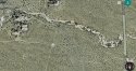
"I've been to those rocks..from ground level you can't see the road or even a semi driving by. The road is below natural terrain as much as 4 feet.
"I took the trail then cut across north to the rocks. On the way back I went south looking to catch the trail. After 20 minutes I look back at the rocks. I don't remember them being that small. I had missed the trail and I was looking for it. I went West and caught the highway a quarter mile south of the turnout."
In my reply, I asked for clarification of the route iscaremyself had taken:
"Thank you for this description. I would be interested in seeing the route you took marked on a map. It sounds like when you went back south from the rocks and missed the main trail, you were on the pole line dirt road--is that right?
From its intersection with the main trail, the pole line road goes south a while (paralleling Kelbaker Rd) and then curves around the east side of another rock formation, although the pole line itself appears to go straight across the rocks, per the Google map. (If you zoom in on the map, you can see the poles.) The road then angles west for a short distance to meet the pole line, then south again and crosses Kelbaker. There appears to be another turnout there, which could have been very confusing to Barbara if she ended up there by mistake."
I didn't get a reply from iscaremyself, so I'm still not clear about the route taken.
Forgive me if this is hard to follow!