Hi again all… well… against all odds I did it!
I found some VIDEO & AUDIO evidence of Storm Cells #1 and #2 on August 15th, 2021. So this is “An Appendix” to my initial post containing the 5 satellite weather GIFs. If you missed that post,
here it is.
(Sincere apologies if my posts are so “long-winded” but if one submits anything “evidentiary” I feel it’s vitally important to document it as thoroughly and succinctly as possible.)
And BTW, please note, my focus in investigating the weather is not to push or promote the “Lightning as a COD” theory one way or the other. I’m just trying to uncover some factual insights about the weather conditions that day to clarify what WAS or WASN’T within the realm of “likely” when it comes to those 2 storm cells, and by proxy, the effect they may have had on on the ground conditions and temperature as well.
----------------------
So… I spent most of yesterday obsessively trying to find some photographic or video evidence of the storm cells that passed over the Gerrish-Chung location that day. You’d think, in this digital age, especially in an area as well visited as Yosemite, that certainly SOMEBODY would have snapped a picture or briefly panned video past the area of sky in question. Nope. Nada.
“Dude, point your camera at the sky for a moment please!” Uuuugh. So frustrating.
Anyway, after a solid day of sifting the internet and scrubbing through perhaps hundreds of YouTube videos – and just as I was about to give up - I finally hit some pay dirt.
--------------------
On August 2nd, 2021 a young woman (I’ll address by her initials - “J.O.” - for digital anonymity), set out with a group of friends to hike the John Muir Trail from the south (Mt. Whitney area) to the north (ending at Yosemite). This is a popular hike that takes about two weeks. She video-taped the entire journey for a vlog and it runs just over 73 minutes.
Though each day only opens with a “DAY XX” caption (rather than a calendar date), in her intro “Day 1” was definitively identified to be August 2nd, 2021, making the film’s “Day 14” August 15th, 2021.
What follows is a time-stamped run down of the sections that relate to the storm cells.
HERE’S J.O.'s VIDEO on YOUTUBE:
(NOTE: AS the WS TOS specifically requires that any statements presented as “fact” be backed up with evidence, I’ve attached two graphics at the bottom of this post that chronicle the technical methods by which I extrapolated my certainty that the cloud formations in the video are indeed Cell 1 and Cell 2 on the day in question.)
Pertinent Time Stamps:
At 49:37 - The day opens with the caption “Day 14” (by “trip day” extrapolation, August 15, 2021).
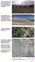
At 52:00 - J.O. is hiking 0.8 miles east of that night’s intended camp destination at “1000 Island Lake”. She’s facing almost due west. Both a caption and her narration identify the lake by name. This lake is 19 miles east of Half Dome in Yosemite Valley at a heading 95 degrees. In front of her, the southern edge of the lake can be seen, and above it a gathering of dark clouds, with a particularly dark knot in the clouds being most evident. This dark area is clearly the beginnings of Cell 1’s build-up, because…
At 52:15 - she says
“It’s 4:30, we made great time…” This welcome auditory time stamp, when referenced with the 4:30PM image frame of the Visible Satellite GIF loop, indicates that storm Cell 1 had just begun to cast some elongated shadows above the Yosemite Valley. This shadow seems to closely match the “dark spot” seen in the sky ahead of her. This is essentially the “birth” of Cell 1. (See “
Hiker-Cloud-Extrapolation-1.jpg” attached below).
At 53:10 - Now at camp, and after having explained that a violent wind had come up for a time, causing a scramble to place rocks around the tents to keep them from blowing away J.O. is seen sitting her tent and comments
"It’s been a crazy hour…". So if we take her
“It’s 4:30…” comment on the trail, then add in the 0.8 mile walking time to camp, plus tent setup time, then the subsequent
“crazy hour”, a reasonable estimate of time would put us at no
earlier than 6PM.
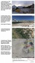
At 53:31 – J.O. is standing outside her tent filming the sky and surroundings. Though it’s possible it could be just wind on the microphone, there seems to be a very distinct background “rumbling” of distant thunder.
At 54:15 – At an indeterminate time afterwards, J.O. is filming the lake and the gathering storm clouds, and suddenly exclaims
“Oooh LIGHTNING…!” and spins the camera quickly to the right, apparently centering on the area where the lightning was just seen (though it wasn’t visible on camera). Then exactly 19.37 seconds later a strong report of thunder is heard, presumably from the lightning seen moments before. This corresponds (with lightning-to-sound distancing formula) to be about 4.2 miles distant. See:
Lightning Distance Calculator
The clock time of this last lightning/thunder footage is uncertain but as it is after the “crazy hour” comment which would be no earlier than 6PM (and she’d been filming a few takes of various things in between) we can generally estimate the lightning occurred no earlier than about 6:15PM.
By 5PM, Cell 1 had matured and began moving toward the WSW toward the Gerrish-Chung location, and by 6PM Cell 2, now just getting started, would have taken it’s place along that same ridge line. The 6:15PM frame from the Visible Satellite GIF loop, also indicates the outer edges of storm Cell 2 were easily within a 4 mile range of the lake, indicating that the lightning J.O. saw and heard, was consistent with having come from Cell 2. (See “
Hiker-Cloud-Extrapolation-2.jpg” attached below).
Admittedly, this doesn’t add a great deal to what we can already assume were the likely meteorological attributes of Cell 1 and Cell 2 judging by their satellite signatures, but it DOES provide some visual confirmation of their extent and character, and of course, a very DEFINITIVE example that lighting was indeed an active attribute of Cell 2.
--------------------
Finally, and I think THIS IS IMPORTANT TO NOTE - in searching the web for photographic evidence of these storm cells, I easily watched over a hundred videos of many individuals both young and old, and in good shape or not-so-much, that were out hiking trails in and around Yosemite that very day or in the hot days surrounding. It wasn’t uncommon to see videos where 10 or 14-mile hikes were easily undertaken. Some of trails were very hard ones. I saw several people climbing Half Dome on August 15th itself, and they were smiling all the way. VERY FEW – if any - mentioned the heat. Granted, Half Dome and many other park trails are at higher altitudes and thus cooler, but it struck me as significant.
And lastly, I wanted to reiterate that the unusual “stand-alone” reading from El Portal of 109 degrees cannot be confirmed to have been in play on the Savage-Lundy trail. As I outlined in my previous post, with one exception (at 105 degrees just 2 miles from El Portal) the dozen or more available temperature stations in the greater Yosemite area (both at higher AND LOWER elevations than at the bottom of Savage-Lundy) all registered MUCH LOWER temps that day. In the range of 7-10 degrees lower - at max.
(For historic temperature recordings in California see the CDEC Station Locator map at
Web Map Viewer and use the “Query Tools” menu link and station ID/date to find historic data).
Yeah, it was HOT that weekend to be sure, but it wasn’t 109 “everywhere”.
Here are my Hiker-Cloud-Extrapolation charts: