IL IL - Timmothy Fry-Pitzen, 6, Aurora, 13 May 2011 - mom found dead - #1

Status
Not open for further replies.
http://www.ankerberg.com/Articles/apologetics/AP1202W2.htm

--"Jehovah’s Witnesses are generally law abiding, with the familiar exception of their religion’s teachings. For example, they often ignore child custody arrangements, kidnapping children and hiding them from the legal parent so they may influence the child into their Jehovah’s Witness religion. "

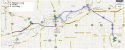
I've always had the Mississippi River in my mind, as last May was when it had it's record floods. So after the forensics we received to day about the grass, weeds, gravel etc, and especially about the pond/creek, I wonder if this area could be the Mississippi back waters.....and sure enough, there is a town called Savana on the Illinois side of the Mississippi River with a Jehovah's Witness church just south of townoff RT 84 and east on Wacker. grasping as usual.
 
The part of the WREX article that I bolded here is what stands out to me:

Sediments and plant material on the vehicle indicate that it was stopped for an unknown period of time on a wide gravel shoulder, gravel road, or short gravel turnout either adjacent to, or just off of, an asphalt secondary road that had at one time, been treated with glass road-marking beads. In close proximity to the gravel shoulder or road where the vehicle stopped, it backed into a grassy meadow or field to a spot that is nearly treeless. There are birch and oak trees in the general area but not directly over or at the spot where the SUV stopped. Both Queen Anne's Lace and black mustard plants grow in a row along the border of the field or the shoulder of the road.

This could mean Amy drove to a house that has a gravel driveway, or a business with a gravel parking lot, and then she backed up over vegetation to turn the car around when she left. Or, if she didn't want her car to be seen, she could have pulled behind an outbuilding or something on a property and gotten the vegetation on the car that way.

Or it could mean that she was literally in a meadow somewhere, but I really don't think so. I get the impression that that's what LE thinks, though.

I really don't think anybody's going to find those toys and toothpaste, because the more I think about it the more I believe he's alive and those things went with him in his backpack to his new home. I think she planned to give him to whoever-it-is months before she did it, that it was all set up for that week in May, and that the reason for the trips to Gurnee and then the Dells were because she started to get cold feet about actually doing it and had to take that little road trip to psych herself up for it.
 
from the WREX article:

Forensic results indicate that the grass was not cut which helps rule out a rural residential lawn or a park.
 
from the WREX article:

Forensic results indicate that the grass was not cut which helps rule out a rural residential lawn or a park.​

I don't know what they mean by 'rural residential'. I sure know a lot of people whose homes are in the country, and they don't do a lot of mowing. For that matter, when we built a house in a newer subdivision, there was an empty lot right next to ours for a few years. We didn't mow it. And I've gone to plenty of yard sales where the wildflowers/weeds came right up to the gravel driveway.

I am not sure I understand the Jehovas Witness connection?

I don't get that, either.
 
FINALLY!!!!!!

Something we can sleuth. This is a great description of the suspected area that Amy went to.

I will try and do a diagram to visually represent what we are looking for. We can go on Google Maps in the narrowed down location, and look for what they are describing here.

The Glass Marking Beads for Roads caught my attention. We don't know how long ago that was on the ashpalt road they are looking for, but, maybe we will get lucky, and it will show up on the Google Maps, which are often dated a few years ago.

That is a significant clue. Would LE be looking into which roads were resurfaced, painted, temporarily re-routed etc., in the last 10 years or so? Why would the road be formally surfaced in the glass beads?

Here is an image and some reference for the Glass Beads used in Highway Marking.

How in the heck did they figure out that the spot the vehicle backed down into was nearly treeless, but that there were birch and oak trees close by, but not directly over. WTH? GO LE!!!
http://www.wrex.com/story/16074147/n...urora-boy-case


-->Sediments and plant material on the vehicle indicate that it was stopped for an unknown period of time on a wide gravel shoulder, gravel road, or short gravel turnout either adjacent to, or just off of, an asphalt secondary road that had at one time, been treated with glass road-marking beads. In close proximity to the gravel shoulder or road where the vehicle stopped, it backed into a grassy meadow or field to a spot that is nearly treeless. There are birch and oak trees in the general area but not directly over or at the spot where the SUV stopped. Both Queen Anne's Lace and black mustard plants grow in a row along the border of the field or the shoulder of the road.


150033829_Highway_safety_road_marking_glass_beads_with_EN1423_1424_standards_240.jpg
 
Here is a picture of the Queen Anne's Lace and Mustard Plants that grow along the border of the field or ditch, followed by a picture of Birch Tree and Oak trees, with their foilage. I will post some other pictures of when the plants/trees would not have their foilage, since that may be when the Google Map Pics were taken.

Queen Anne's Lace:

QueenAnnesLace1.jpg


Black Mustard Plant/Weed:

mustard_weed.jpg


Birch Trees:

CelticMeaning-BirchTree.347233521_std.jpg


Oak Tree:

Oak-white1.jpg


http://www.gardening-for-wildlife.com/images/Oak-white1.jpg
 
In addition, there is no corn growing in or adjacent to the spot where the SUV stopped, nor is there any indication that the area had been used for agriculture in the recent past.

Instead, the evidence strongly suggests that grasses have been the only major plants growing in the immediate area which leads scientists to believe that it is a meadow and not, for example, a field that had once been farmland and not recently sown.

Forensic results indicate that the grass was not cut which helps rule out a rural residential lawn or a park. There is also a strong likelihood that there is a pond, small stream, or creek in the area.

Scientists further believe that the meadow is most likely in Northwestern Illinois with Lee and Whiteside Counties as the most likely locations. However, areas in Carroll, Ogle, Stephenson, and Winnebago Counties cannot be ruled out at this time. The last time anyone had contact with Timmothy was on May 13 when he talked to a relative on Amy's cell phone at about 1:30 p.m. That call was traced to a point about five miles west of Sterling, IL, near Route 40. Further processing of the materials found on the vehicle are continuing.


http://www.wrex.com/story/16074147/n...urora-boy-case

Map Showing Sterling, Whiteside (left) and Lee (right) Counties:


attachment.php


Sterling, Illinois:

http://maps.google.ca/maps?q=sterli...code_result&ct=title&resnum=1&ved=0CBwQ8gEwAA


Lee County Illinois:

countymap_thum.gif


statemap.gif


Lee County is located in Northern-Central Illinois. It has two interstates running through it, I-88 and I-39, several U.S. highways and state routes, and the Rock River runs through the Northwestern corner of the County.

http://www.countyoflee.org/maps.html


Whiteside County, Illinois:

attachment.php


http://maps.google.ca/maps?q=whites...code_result&ct=image&resnum=1&ved=0CCYQ8gEwAA


Whiteside County is divided into these Civil township - Wikipedia, the free encyclopedia:


Whiteside_County_Illinois_1836.png


http://upload.wikimedia.org/wikipedia/commons/1/19/Whiteside_County_Illinois_1836.png
 

Attachments

  • whiteside.JPG
    whiteside.JPG
    41 KB · Views: 220
  • whiteside_sterling_lee_2.jpg
    whiteside_sterling_lee_2.jpg
    60.4 KB · Views: 224
I don't recall if this angle has been discussed - the store in Winnebago then motel in Rockford would suggest the mom was traveling East at the end. Looking at maps, I think the mom would have most likely traveled West or North from where they made the calls in the Sterling & Rock Falls area. That would put her in position to drive East into Rockford.

Edited to add more: Recalling that LE says the last phone calls were 5 miles NW of Sterling, near Rte 40, that should narrow it down further. Where would she have gone, that required going up 40 from Sterling, then end up where it made sense to travel along through Winnebago to Rockford. Still a large area, of course, but somewhat narrowed down...
 
And I'm also wondering. The two previous trips to the area, one she left the toll in Dixon, IL at 4:45 pm and was back at 8:58 pm. The second, she left the Dixon toll at 9:59 am and was back there at 3:42 pm. That seems like too many trips and too much time, to scout out an area to dispose of a body IMO. Was she meeting with someone? Or doing something else?

And Edited to add: I think wherever she went, that Rockford was maybe the closest large town, the closest motel. But driving through Dixon and Sterling was the fastest way to get there from further afield. Does that make any kind of sense?
 
Like MarthaM, I'm really not sure how LE can rule out a residential rural area. With this economy there are so many foreclosures which banks are not maintaining. How could LE rule out a rural residential area without determining the age of the plants? And even then, it's possible a rural residence could be vacant and not maintained for several years.

jmo
 
More info here. LE hopes to narrow the search areas and maps using the info from the SUV, and they expect more results:

Birch and oak trees and Queen Anne's Lace and black mustard plants grew near the spot where the SUV stopped, the report states. The land was not agricultural, and "the evidence strongly suggests that (uncut) grasses have been the only major plants growing in the immediate area," according to the report. A pond, small stream or creek is nearby, police said.

Ferrelli said the report eliminates farm fields as a place to search. Ongoing analysis of the SUV is expected to yield additional information that can be used with detailed maps, which may allow investigators to pinpoint search locations, Ferrelli said.

http://www.chicagotribune.com/news/local/ct-met-pitzen-police-update-20111119,0,7857510.story
 
I don't recall if this angle has been discussed - the store in Winnebago then motel in Rockford would suggest the mom was traveling East at the end. Looking at maps, I think the mom would have most likely traveled West or North from where they made the calls in the Sterling & Rock Falls area. That would put her in position to drive East into Rockford.

Edited to add more: Recalling that LE says the last phone calls were 5 miles NW of Sterling, near Rte 40, that should narrow it down further. Where would she have gone, that required going up 40 from Sterling, then end up where it made sense to travel along through Winnebago to Rockford. Still a large area, of course, but somewhat narrowed down...

And I'm also wondering. The two previous trips to the area, one she left the toll in Dixon, IL at 4:45 pm and was back at 8:58 pm. The second, she left the Dixon toll at 9:59 am and was back there at 3:42 pm. That seems like too many trips and too much time, to scout out an area to dispose of a body IMO. Was she meeting with someone? Or doing something else?

And Edited to add: I think wherever she went, that Rockford was maybe the closest large town, the closest motel. But driving through Dixon and Sterling was the fastest way to get there from further afield. Does that make any kind of sense?


Thanks, Obody.

I am going to start on the Google Map walk-about, at Dixon, and the follow the river north-east.
 
Forgive me if it's been discussed, but, has the White Pines Forest Nature Preserve been discussed?

Among the park’s most interesting features are the concrete fords that span the creeks, allowing the visitor, quite literally, to drive through the flowing streams. Also, a newly added benefit for those physically challenged are four concrete sidewalks leading up to the stream bank for viewing or angling

http://dnr.state.il.us/lands/landmgt/parks/r1/whitepns.htm#Camping
 
Wondergirl, thanks for bringing this new plant info to my attention- I will start catching up on the case and start looking at maps as can...in the middle of a move, so hectic....
 
Status
Not open for further replies.

Members online

Online statistics

Members online
153
Guests online
2,619
Total visitors
2,772

Forum statistics

Threads
595,092
Messages
18,018,485
Members
229,573
Latest member
AMK
Back
Top