TX TX - Falls Co, Hisp/Poss Asian AdmxFem 20-45, UP3514, wrapped in quilt, heart charm nklce, Apr'00

You haven’t made it far enough north then :D:p
 
Here's a closeup of the field those coordinates point to: Google Maps

There are several of the pond-type stock tanks in the immediate vicinity.

I don't see CR 451 anywhere near here, though.
I found the intersection of County Road 451 and I-35. It is south of Waco & north of Temple. CR 451 only goes southeast. On the map, I followed CR 451 until it meets CR 452 which is also labeled Texas Farm Rd 1239. At that point, CR 451 continues across the intersection but it’s name changes to CR 459. If I was better at mapping, I would guess that is 4-5 miles inland. Many 90 degree turns along the way.

Lots of land, ponds, few homes. Now if her remains were left at night, it would be difficult to be stealth. That appears to be so rural, it would be pitch black at night. People who live out there are used to the normal nightly sounds. They'd probably look out the window if they heard a vehicle. Their dog would go nuts.

If the remains were left during daylight, I suspect the perp was a local. Someone who would not raise suspicions, riding a 4 wheeler, driving an old pickup, etc. so someone who knew there would be a stock tank. Better to hide remains so they aren’t visible from the road. The ground could have been too hard to dig. Maybe not enough foliage to cover the remains. Regardless, this perp was lazy & lucky. But they won’t be lucky forever, DNA is on file. Hoping she gets her name back and goes home soon.
 
This shows Route 77 from Waco to the coast (Corpus Christi was a convenient spot to map). Jane Doe's location is at the dot labeled "Falls County". Google Maps

Vietnamese refugees fleeing the war settled along the coast in the 1970s and there's also a Filipino population. I don't remember exactly what towns they're in.
I think she was found west of this map.
 

Attachments

  • 79740D66-D8FA-4777-B2C7-B11EF5540632.jpeg
    79740D66-D8FA-4777-B2C7-B11EF5540632.jpeg
    73.5 KB · Views: 21
  • 6766B8E6-05E8-4091-9945-9272AE7F6700.jpeg
    6766B8E6-05E8-4091-9945-9272AE7F6700.jpeg
    252.3 KB · Views: 23
I used the coordinates from the Namus map, but I'm not convinced they're correct. The CR451 intersection you found sounds more accurate.
Yes I looked at those coordinates also and as you stated, CR 451 wasn’t nearby. I’m wondering now who owns that land and how long have they owned it. It looks like a big farm at the CR 451 & CR 452 intersection.
 
Zooming in on I-35, there is an under the overpass turn-around for the service road. No exit. There’s not a lot of businesses. This wasn’t a trucker passing thru, dumping a body. This was someone within driving distance that knew the area.
 

Attachments

  • F1099615-BB92-4943-8991-047008DB7293.jpeg
    F1099615-BB92-4943-8991-047008DB7293.jpeg
    166 KB · Views: 4
Okay! Right there where 452 turns in 1239 there’s a ...something. I guess a farm. There are round hay bales, some kind of pin and several things that could be stock tanks (y’all are going to make me open my Google Earth lol) and there’s also a “small water tower”... I associate those with dry feed but they may be used for water.

So I guess it depends on the person who wrote the report and what they considered a stock tank. I do not think it was one of those ponds though. You mentioned them coming onto the landowner’s property at night and dogs barking and such. That would 100% be the case if the home was occupied. Another reason why this detail is important IMO. If it was unoccupied and even a large enough piece of property, they may not have alarmed anyone or anything to their presence.

Now, a strange vehicle driving around the area at any time of day or night would probably raise suspicion. Unless there was something in the area that would have sporadic traffic. A dairy or feedlot for example. I’ve worked on a very rural cattle feedlot during the middle of the night, and a passing vehicle might not be cause for concern. If it pulled up anywhere near the lot for any period of time, now that would warrant investigating.

JMO

(carbuff, I think same road just broken up...but I still get lost and I’ve lived around these type roads all my life lol)
 

Attachments

  • E58C31F3-E051-428C-9451-0FACD8366A01.jpeg
    E58C31F3-E051-428C-9451-0FACD8366A01.jpeg
    182.8 KB · Views: 7
One thing I haven’t found on these satellite images....livestock.
Me either which makes me think chicken farm? I do see Eddys Feed & Seed, Helena Chemical and a liquor store at Texas Rd 7 / 107 which connects to the same intersection of CR 451 & CR 452. Again, no obvious I-35 Exit from zooming in on the overpass. Just the service road.
 
In that part of Texas many of the interstates have frontage roads running parallel to the big highway, with underpasses and intersections every so often. Instead of cloverleaf-style intersections, you enter the highway from the left lane of the frontage road in between the underpasses. You can wind up driving three or for miles to get to something that's directly across the highway from you.

Yes, that long barn looks like chickens to me.
 
13730613-434B-4A10-A2B5-FE8B52F7FC4B.jpeg 4FEF3E0A-7FDF-4092-969B-A2B71F5FB928.jpeg DB5695A7-DB3C-4682-8F33-ADCC1067F8B6.jpeg
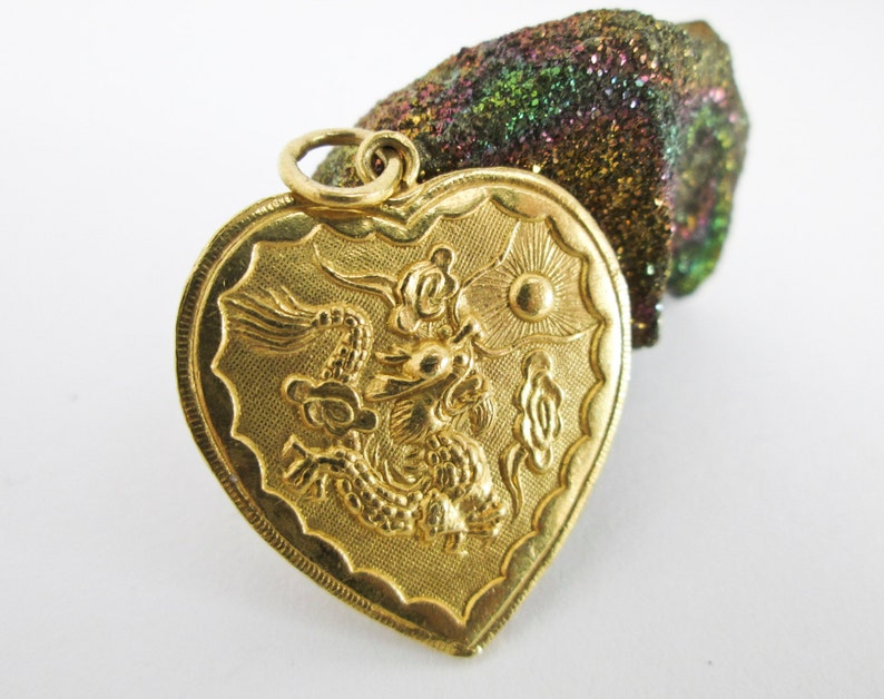
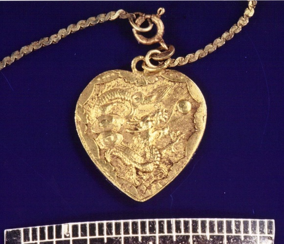
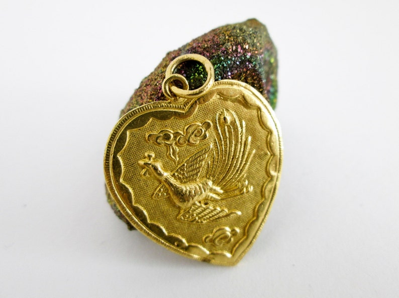
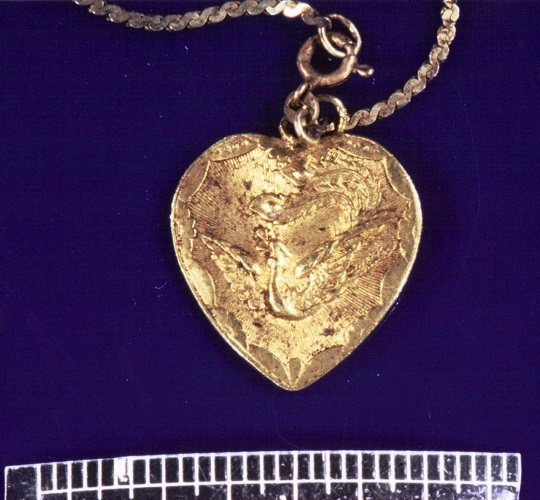
Namus description of the necklace: Yellow metal, heart-shaped charm with a dragon on one side and a bird on the other.

A heart-shaped charm with a dragon on one side and a phoenix on the other is a Chinese marriage charm, also popular with Westerners. I think it's also used as a general good luck charm.

Some typical examples: New Handcrafted 925 Silver Chinese Double Happiness for Wedding Phoenix & Dragon Heart Charm Pendant Reversible Design

Photos from Doe Network - cameo from her blouse and the necklace
 
I can't see it well enough to make out the design...sigh. I don't know why my eyes are so much worse than they used to be. They aren't any older than the rest of me.

Dear, it is not your eyes, but bad image of very deteriorated necklace.

This image of Etsy is very similar, I would say "almost" identical to one found with her. On her necklace you can make out similar dragon, its tail and also that little round ball on top right side. 1st image is etsy, 2nd is her neclace.
il_794xN.685017183_52oh.jpg
518UFTX2_LARGE.jpg


Back side of the necklace of bird is slightly different. On her pendant it seems bird has spread out/open wings. 1st is etsy image, 2nd is hers.

il_794xN.685017229_rxk1.jpg
518UFTX3_LARGE.jpg


Large 1960s Chinese Dragon & Phoenix Heart Pendant | Etsy
 
Last edited:
With regards to stock tank. I googled it too as I was not sure how it looked like. However, I have found a link which timed out here from 2015 police press release. Her skull was found near the pond. In whole press release there is no mention of stock tank so it is fair to assume that stock tank = little pond where skull was found.

New working link for 2015 press release - TXDPS - September 14, 2015 Texas Rangers Seek Information About Unidentified Deceased Woman Discovered in Falls County

Quote from press release:
The Texas Department of Public Safety (DPS) is seeking the public’s assistance in identifying a woman whose remains were discovered in 2000 in Falls County. Based on multiple forensic analyses, investigators estimate that she died in the mid-1980s to possibly early 1990s.

On April 9, 2000, fishermen found a skull at the edge of a pond on County Road 451, approximately five miles from Interstate 35 in Falls County, just south of Waco. Additional remains were discovered with clothing and other personal items, and foul play is suspected in the woman’s death.

A DPS Texas Rangers forensic artist was able to develop a facial reconstruction from the skull. The above image represents the victim’s probable appearance in the mid-1980s. The victim is believed to be of Hispanic and/or Asian descent, age 25 – 45, and between 4 feet 7 inches and 5 feet 3 inches tall.

A DNA profile has been developed from the bones recovered; however no matches have been made to any known missing person case. It is possible this woman was never officially reported missing.

Among the items found with the remains was a gold pendant, featuring a fire-breathing dragon on one side and a bird on the other side. According to research done by investigators, the images on the necklace may be a depiction of the dragon and phoenix myth, common in Asian culture.
 
Map and bad eyesight - Few days ago I have spent hours searching for doomed CR 451 under Waco as I was curious myself where she was found. I searched every crooked and cranny of that area on google maps, folowed all instructions here, found everything and every road, path, intersections and farms mentioned here but not CR 451.

Or I have very bad eyesight or I am starting to believe that my google map is just different for whatever spooky reason.

Can anyone help me out by screenshot or link showing which approximate close area she was found in? Not to the left or west or right, but of that area, showing CR 451, if anyone knows? Really, all help is appreciated.
 
Yeah, it really could be many things. I know what you mean about stock ponds and even just a man made or natural pond out in a pasture. I don’t think tank and pond are interchangeable in this case. But again, that’s where more detail about the tank would help tremendously.

If the coordinates on NamUs are correct (I doubt it but it will work for demonstration purposes) the area is rural. It was about 5 miles from I-35, one the largest thoroughfares in the state, but it was right off of Hwy 77. It would convenient for anyone wanting to get off of the busy I-35 and find a remote are to dump a body.

Highway 77, from Waco, connects to several other towns (Rosebud, Cameron, Rockdale, La Grange, Schulenburg, Victoria, to name a few)..and continues south to and along the Gulf coast all the way to Harlingen and Brownsville; at the border of Mexico. If I had to take a wild guess, whomever may have dumped her could have just as likely traveled 77 as they could 35.

I haven’t read a lot about this case, but that theory might support her being Hispanic and not Asian.

JMOO

(not sure how to share links to Maps, but I’ll try...)

31°09'49.1"N 97°00'24.6"W
https://goo.gl/maps/CvvHi4PAUmHbjEMJ8
I’ve been looking at real estate in that vicinity (central TX) and I’ve noticed a stock pond is commonly called a stock tank in the area. Had me a bit confused at first. Basically anything that holds water man made or natural goes by stock tank.
 

Members online

Online statistics

Members online
154
Guests online
3,968
Total visitors
4,122

Forum statistics

Threads
592,524
Messages
17,970,360
Members
228,793
Latest member
Fallon
Back
Top