Malaysia airlines plane may have crashed 239 people on board #10

Status
Not open for further replies.
UK offers help in search for plane

http://www.harwichandmanningtreesta...50.UK_offers_help_in_search_for_plane/?ref=nt

Prime Minister David Cameron has telephoned his Malaysian counterpart to offer Britain's help in dealing with the disappearance of Flight MH370.

It was the first direct contact between the two prime ministers since the mystery began, said Mr Cameron's official spokesman.

The spokesman said Mr Cameron did not make specific offers of particular military or civilian assistance that the UK might be able to provide.

"It was very much inviting any specific requests from the Malaysians," he explained. "Prime Minister Najib said he would think about that and let us know if they have any specific requests."

"Prime Minister Najib thanked him for that and they agreed to stay in touch on this issue."

BAH! No, his answer should have been "YES PLEASE, SIR! That would be VERY helpful and welcomed"..... 10 DAYS AGO.
 
New search widened to circle 6 (sorry, don't know how to reduce size):

11tu8lc.jpg


http://online.wsj.com/news/articles/SB10001424052702303287804579444310796437796
 
Jersey Girl, if you can--see if you can resize that wonderful map to about 700 pixels wide, so as not to blow the margins? (Holler if you need help.)
 
After looking at this again...the time difference makes it all wrong. I was really hoping this was a genuine sighting but they are 3 hours behind kl so their sighting was at 910am kl time. 1 hour after the last ping.
Also I think your previous post re between the maldives and diaego garcia is actually where the satellite is. They do not fall inside the corridors of the last ping. Hope this makes sense.

Do we know that the 8:11 time from INMERSAT was KL local time? I have no idea..............or was it some universal time not translated into a local time. DUH, dunno jmo
 
Jersey Girl, if you can--see if you can resize that wonderful map to about 700 pixels wide, so as not to blow the margins? (Holler if you need help.)

I'm hollering!!! I'll go see if it's posted on the main forum page.

EDIT: Can't find anything in the other threads as to how to reduce size. I know it was posted inside one of these 10 missing threads but no way could I search for the info.

A mod should post instructions in the timeline thread.

If anyone can explain, I can reduce.
 
Has this been posted? If not allowed, Mods please remove.

There has been a lot of speculation about Malaysia Airlines Flight 370. Terrorism, hijacking, meteors. I cannot believe the analysis on CNN; it’s almost disturbing. I tend to look for a simpler explanation, and I find it with the 13,000-foot runway at Pulau Langkawi.

We know the story of MH370: A loaded Boeing 777 departs at midnight from Kuala Lampur, headed to Beijing. A hot night. A heavy aircraft. About an hour out, across the gulf toward Vietnam, the plane goes dark, meaning the transponder and secondary radar tracking go off. Two days later we hear reports that Malaysian military radar (which is a primary radar, meaning the plane is tracked by reflection rather than by transponder interrogation response) has tracked the plane on a southwesterly course back across the Malay Peninsula into the Strait of Malacca
More at link.

http://www.wired.com/autopia/2014/03/mh370-electrical-fire/

I read this earlier and think it makes so much sense. If they could pinpoint where the plane would have flown until it ran out of fuel (using Langkawi as a trajectory point) it may well have near the southern Maldives.

EDIT scrap that, just seen Jersey Girls massive map lol!
 
Why the plane was NEVER near the Maldives at any time.
(Assuming the satellite ping data is true.)

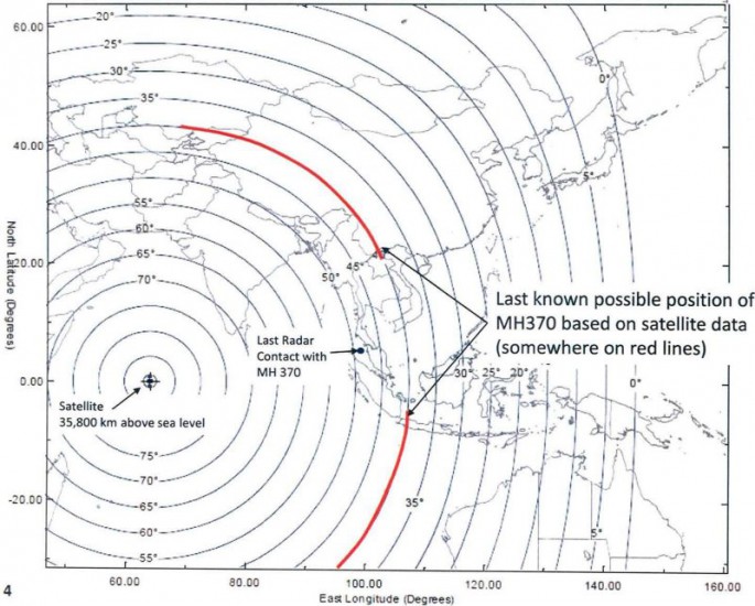
According to investigators, raw ACARS satellite ping data shows that at 8:11am Malaysian time on March 8, MH370 was at a location somewhere along the two red lines on the map below:

wn84h50.jpg


Therefore, at 8:11am, the plane was nowhere near the Maldives (or Diego Garcia). Now, published reports say some Maldive locals saw a low-flying plane at 6:15am local time. As another poster pointed out, that would be 9:15am Malaysian time, around the time MH370 would have run out of fuel.

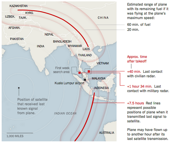
So could MH370 have flown from its 8:11am location on one of the arcs to the Maldives? The map tells the tale:

oqwP9X2.png


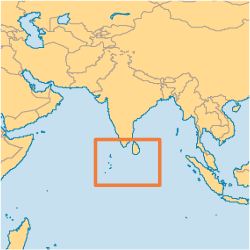
The answer is no. The plane could not have gotten anywhere near the Maldives, which are located south and west of the tip of India (the small dots on the lefthand side of the rectangle on the map below):

uA43oFn.png


Scroll back up to map #2, and put a dot where the Maldive Islands are. The only way it could have passed there at all would have been to make a beeline for the Maldives after leaving military radar, then make a beeline to the nearest point on the arc where it HAD TO BE at 8:11am. It's a nonsensical route for anyone's purpose (suicide, terror, etc.). Even if it occurred, the timing would have been very, very tight and it would have had to pass over the Maldives around 2:15am local time, NOT 6:15am.

Thus the Maldives sighting of a low-flying plane at 6:15am can be ruled out.

If the ACARS satellite ping data is accurate, there is zero chance the plane landed or crashed in or near the Maldives or Diego Garcia.
 
I don't think the idea of a "test flight" is a bad theory, but I'd be fairly confident this could not happen in the States. I suppose, with refueling, the jetliner could go the distance. But after 9/11, if America saw a foreign jet, that wasn't on the radar and not communicating, traveling toward/into our airways, they'd have air defense up there and trying to communicate and ground the plane in tens of minutes, and likely shooting it down if they didn't get a proper response or the jet didn't comply!

No, but that's exactly it - I'm not saying from the States - I'm saying an American flight (which would have majority American passengers on it), but leaving from someplace like KL or Bangkok.

So the test would be to test countries' radars, test the whole flight plan, test everything, b/c the real mission is supposed to be in that area.

You are right about it would be much less likely to be able to happen here - that's why they might have decided to do it there. YKWIM?

Not to mention, much easier for the terrorists to get into the countries in the first place.
 
TigerBalm posted these step by step instructions for pic loading on another thread, and I bookmarked them as they are super helpful (the link is a single post, no need to weed through to find it)-

[ame="http://www.websleuths.com/forums/showpost.php?p=10269839&postcount=531"]Websleuths Crime Sleuthing Community - View Single Post - GUILTY Officer Padron’s accused killer, Brandon Daniel, to stand trial[/ame]


Shout out to Tiger :tyou:
 
Maldives police on Tuesday announced an investigation into reports that residents of the remote Maldives island of Kuda Huvadhoo in Dhaal Atoll have seen a "low flying jumbo jet" on the morning of the disappearance of the Malaysia Airlines flight MH370.

But the police did not reveal any details.

http://www.haveeru.com.mv/news/54067
 
Jon Ostrower ‏@jonostrower 8m

Missing disclosures: How much fuel did #MH370 have at takeoff? What do the pre-8:11am pings show? How does sat. data illustrate FMC changes?
 
That's disgusting, unconscionable and suspicious IMO! An international crew shows up in a spirit of cooperation to help find 239 missing people, and Indonesia grounds them indefinitely because of politics. I hope there's some way to put pressure on them to allow the search. No families should suffer further because of some bureaucratic red tape.

Talk about politics, look at this post which was made at the end of the last thread: (Post #952, JerseyGirl)

Foreign ministry spokesman Hong Lei did not say directly yesterday whether China would share its radar data, saying only that Beijing was willing to "proactively co-operate with Kuala Lumpur if it was beneficial to the search".

Chinese radar experts were divided over whether the plane could have flown undetected into Chinese airspace, but all agreed the radar data was so sensitive that a decision to share it could only be made "at the highest level".

Beijing-based military expert Li Jie said China had started a search of its territory because it did not want to miss any opportunity to locate the lost flight.

"There is still a slim chance that such a big plane could evade radar detection, so China should spare no effort to find it," he said.

http://www.scmp.com/news/china/artic...inese-airspace


So China is starting to search their western lands....AND they are not willing to "give up" their radar................

hmmmm................

Methinks China has radar of an unidentified plane flying through their Western lands.

JMO.
 
I don't have a link as it was stated on CNN. Nothing suspicious was found on Pilots simulator.
 
I'm so confused at this point, I don't even know if there was a plane:ufo:

My husband said more or less the same thing... I'm not so sure, but he seems to think there's 239 families who can claim some sort of cash benefit from it?
 
They will more than likely, never know what was on the pilots personal laptop, since he had it with him.
 
Status
Not open for further replies.

Members online

Online statistics

Members online
66
Guests online
4,058
Total visitors
4,124

Forum statistics

Threads
592,547
Messages
17,970,832
Members
228,807
Latest member
Buffalosleuther
Back
Top