Australia Samantha Murphy, 51, last seen leaving her property to go for a run in the Canadian State Forest, Ballarat 100km NW of Melbourne, 4 Feb 2024 #8

Status
Not open for further replies.
Mr Bezzina is not involved in this investigation and would not be aware of the intelligence at hand and exactly what that intelligence related to in this search.

Exactly. He would have no idea what the VICPOL know and what tactics they are using

He's trying to be important, receiving a pay cheque

He is certainly no Ron Iddles !
 
Last edited:
<modsnip - discussing moderation on the thread>

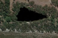
Here's number two on the possible list of locations the body could have been disposed of, considering the alleged rumours of Recreation Road being shutoff.

Can anyone here identify if this is a sink hole?
If it is, how deep do these things go? Any experts on this?
Looks dark, deep and very close to the road.

Recreation road - Sink hole.jpg

Link to possible sink hole on Recreation Road

It's also on Recreation Road, where the alleged police operation took place.

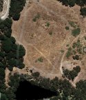
edit: This is definitely something locals would know about, but only now are others are becoming aware of.

This is obvious by the many car tracks above it.

possible sink hole driving tracks.jpg
 
Last edited by a moderator:
Isn't it a kind of lake ????
It does look like some kind of lake with a creek or drainage system running through it. It also looks deep due to the dark and seemingly clear imagery provided by satellite. Maybe a man made catchment to help with road flooding. As there appears to be quite a few in the area.

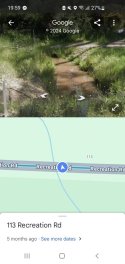
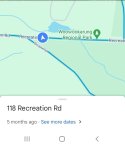
113 Recreation Rd
Screenshot_20240327_195940_Maps.jpgScreenshot_20240327_200145_Maps.jpg
 
Last edited:
It does look like some kind of lake with a creek or drainage system running through it.

You're pic looks nothing like the image I posted. Can you please provide a link to your image as per WS guidelines.
 
You're pic looks nothing like the image I posted. Can you please provide a link to your image as per WS guidelines.
Its on google Street view. I don't know how to link that. It's not a photo of the lake, but the small channel running from it looking from the link you provided. The lake/sink hole is behind thick trees.

I'm not trying to discredit you. Just offering my opinion on what it is.
 
Due to the lack of information from official sources speculation abounds.

It seems my mention of the water tank hit some nerves and posts were deleted. So I'll leave that alone for now.

Here's number two on the possible list of locations the body could have been disposed of, considering the alleged rumours of Recreation Road being shutoff.

Can anyone here identify if this is a sink hole?
If it is, how deep do these things go? Any experts on this?
Looks dark, deep and very close to the road.

View attachment 493099

Link to possible sink hole on Recreation Road

It's also on Recreation Road, where the alleged police operation took place.

edit: This is definitely something locals would know about, but only now are others are becoming aware of.

This is obvious by the many car tracks above it.

View attachment 493100
It is a substantial man made ‘dam’ taking advantage of the lands natural run off and a watercourse runs through it . I have once walked the western end of this dam from the north , coming out at the farm fence adjacent to Recreation Rd . The cleared area in the pic on the north side was once long gone farm buildings , there is no immediate dwellings now , it’s a little isolated and although fenced all around the vehicular activity you see could indicate the fencing has fallen in disrepair … I’ll scout around this Sunday and confirm . <modsnip - hearsay>
Vehicular access from the western track off Dozed Rd would be the most discreet entry for a perp wanting to dump a body .
I imagine this dam would have been subjected to VicPol’s attention in that initial thorough Mt Clear crime scene examination .No expert on depth , it does look deepish , possibly 3-4 metres in the middle IMO..
 
Last edited by a moderator:
Vehicular access from the western track off Dozed Rd would be the most discreet entry for a perp wanting to dump a body .
I imagine this dam would have been subjected to VicPol’s attention in that initial thorough Mt Clear crime scene examination .No expert on depth , it does look deepish , possibly 3-4 metres in the middle IMO..
Have we seen any police divers during the searches? How are they checking all of the water spots?
 
Just going over earlier reporting again, it seems that by 23/02 either Sam’s murder wasn’t yet determined, or wasn’t being revealed. The 7am to 7pm time slot mentioned tells me that they are by this time aware of the 5pm ping. Do you think Sam’s death was known by this time or did something inform them of it later, ie between 23/02 and 06/03?

23rd February:
"Unfortunately given the time and the fact we've found no trace of her, we do have severe concerns and are very doubtful that she is still alive," Det Supt Hatt told reporters in Mount Clear on Friday.

Detectives are also urging anyone travelling through the area, particularly between 7am and 7pm on Sunday, February 4, who may have dash-cam footage to also check this for possible sightings.

 
<modsnip - discussing moderation on the thread>

Here's number two on the possible list of locations the body could have been disposed of, considering the alleged rumours of Recreation Road being shutoff.

Can anyone here identify if this is a sink hole?
If it is, how deep do these things go? Any experts on this?
Looks dark, deep and very close to the road.

View attachment 493099

Link to possible sink hole on Recreation Road

It's also on Recreation Road, where the alleged police operation took place.

edit: This is definitely something locals would know about, but only now are others are becoming aware of.

This is obvious by the many car tracks above it.

View attachment 493100

That has been searched, was on the news in the beginning and one of the first waterways police carried out

As part of their air wing operations, fly over
 
Last edited by a moderator:
Have we seen any police divers during the searches? How are they checking all of the water spots?
I don't believe divers have been used as yet, I certainly have heard no mention in any media reports. For whatever reason water sources don't seem to be high on the list of search locations and I don't understand why.
 
I don't believe divers have been used as yet, I certainly have heard no mention in any media reports. For whatever reason water sources don't seem to be high on the list of search locations and I don't understand why.

I posted links to the Day Six presser further back. The officer said (when asked by a reporter) that they were searching dams and mines.

imo and Link
 
As it’s a farm dam on private land it’s not likely to have a public name as such .
Thank you. That body of water is in the map from Whatson's image provided above and there is an image of it also. I can find no information about it anywhere.
 
Status
Not open for further replies.

Members online

Online statistics

Members online
48
Guests online
4,221
Total visitors
4,269

Forum statistics

Threads
592,490
Messages
17,969,787
Members
228,789
Latest member
Soccergirl500
Back
Top