A person using the alias Dan Cooper skyjacked a Boeing 747[...]
A Boeing 727
")

A person using the alias Dan Cooper skyjacked a Boeing 747[...]
Interesting, I think he's the guy based on what she's been able to tell police but no reputable outlets are reporting it yet.
Respectfully snipped to save space.
I'm east coast Canadian now living in Indiana, I am often told I must be from MA, ME, or NH.
I found it no prob,
What can we tell about what the flight 305 crew could see on/from the ground a bit after 8pm from the aviation weather reports from the night of the hijacking (the ones case agent Larry Carr provided to the dropzone forum)?
The information that is significant for this question is the cloud cover ("sky condition") information in the 8pm and 9pm reports for Portland International Airport (PDX), Toledo airport (TDO), and Troutdale airport (TTD). The listings legibly covered no other locations in the area.
A different kind of information in the reports is about "visibility," which to meteorologists and pilots is about air clarity (which is always good when the air is being, or has recently been, cleaned by precipitation). The horizontal visibility was lowest for PDX (7mi at 8pm, 10mi at 9pm). Vertical visibility was reported only for Troutdale (7000' and 5000').
Before addressing the cloud cover reports, let me explain some about what the cloud cover information is. Imagine you're standing at some observation point and looking all around at a clear sky. You can imagine that all you see up there is painted or projected onto the inside of a hemispherical globe. It's like in a planetarium for looking at night sky.
Now imagine putting some cloud out there in the space between you (at the center of the globe) and the inside surface of that hemispherical globe. This cloud blocks the view of some portion of the inside surface. The blocked portion is the "cloud cover" in the weather reports. If the clouds block 6/10 of the view of the sky (the inside of the globe) from the center of the globe, the cloud cover in the weather report would be "broken" (abbr "BKN"). The data in the reports are about cloud cover as observed from specific points, typically at airports.
Let's relate this to the question about what the flight 305 crew could have seen on the ground. Imagine yourself to be a fly. You're flying around up near the inside surface of the sky globe. If you are at some place where that inside surface can't be seen from the center of the globe (the observation point for the cloud cover report), then you can't see the center of the globe. If you fly to some place that can be seen from the center of the globe, then you WILL be able to see the observation point.
In the case of that 6/10 cloud cover mentioned above, there would be 6/10 of the sky view where you could fly and not be able to see the cloud cover observation point - and there would 4/10 of the sky where you could fly and be able to see the observation point.
So a flight crew at any point in the sky that can be seen from the ground observation point can see that observation point. If the flight is in a volume of sky that can't be seen from the observation point because of intervening clouds, the flight crew can't see the observation point. If the sky where you are can't be seen from the cloud cover observation point at PDX, then you won't be able to see that observation point at PDX. So there would be little chance you could see any part of PDX. If you're in sky that CAN be seen from the PDX observation point, then you will be able to see the PDX observation point (and probably much of PDX, if not all of it).
The significant thing about the 8pm and 9pm reports for all three stations is that all three stations had "overcast" (abbr. "OVC") layers at both times. So what does "OVC" mean? It does not mean that view of the whole sky is blocked by clouds. The definition of "overcast" includes two things. First, "overcast" means that over 9/10 of the sky is blocked. So up to 10 percent of the sky could be seen beyond the clouds and still have been reported as OVC in the aviation weather reports. But there's more.
The reports say that an OVC cloud layer existed with the cloud bases at given altitudes. But an OVC layer doesn't block that over-9/10 by itself. The OVC by definition includes the blockage by the lower-level layers. It's the same for definition of the lower-level "broken" cloud layer. It is said that the blockages used to categorize a cloud layer are cummulative. Another way of looking at it is that you're assuming (in categorizing a layer) that any part of the sky that is blocked by a lower layer has cloud behind it.
For example, say there is only one layer of clouds below the "OVC" layer and that it blocks 70 percent of the sky (making it a "broken" cloud layer). Then, if the OVC layer had no cloud whose view was blocked by the lower BKN cloud layer, the OVC layer would have to block only a bit over 20 percent in order to be called "OVC." The two layers together block over 9/10 of the sky, so the upper layer would be reported as "OVC." As another example, a layer could be reported "OVC" if it blocked 4/10 of the sky and a lower layer blocked 51 percent of the sky.
So, when an OVC layer was reported at 8pm for PDX, there was up to 10 percent of the sky directions from which a plane could have seen PDX. And, if conditions were right, other places on the ground could have been seen by looking through openings in the clouds at different elevations. A flier could have looked through an open area in the OVC layer, through the space between the OVC layer and the lower BKN layer, then through an open area in the BKN layer to see someplace (or places) other than PDX on the ground.
Besides these possibilities, it should be noted that the reports were for specific places. If observations had been made at other places, the conditions reported would likely have been different. There probably would have been an OVC layer for any location in the area, but this is not certain. There was significant difference between the reports for PDX and Troutdale, even though the airports are quite close to each other.
Furthermore, the reports were for specific times. A few minutes after 8pm the conditions would have been different. Ability to see Portland or Vancouver area might have been worse than at 8, or maybe better.
Finally, there is another thing about the definition of "overcast" layer. To be classified as an "overcast" layer, more than half of the sky cover must be OPAQUE. I haven't checked about how much light blockage was required to be considered "opaque." But this part of the definition means that up to half of the cloud cover could pass some significant amount of light and still be considered "overcast." So, besides the fact that the OVC reports allow for considerable unobstructed view, especially for places other than the reporting stations, they allow for "glow" passing through at least 45 percent of the sky view.
...... Hominid thinks 99 is speaking in what he describes as 'meteorology/pilot speak', whatever that is.
....
G.
What can we tell about what the flight 305 crew could see on/from the ground a bit after 8pm from the aviation weather reports from the night of the hijacking (the ones case agent Larry Carr provided to the dropzone forum)?
The information that is significant for this question is the cloud cover ("sky condition") information in the 8pm and 9pm reports for Portland International Airport (PDX), Toledo airport (TDO), and Troutdale airport (TTD). The listings legibly covered no other locations in the area.
A different kind of information in the reports is about "visibility," which to meteorologists and pilots is about air clarity (which is always good when the air is being, or has recently been, cleaned by precipitation). The horizontal visibility was lowest for PDX (7mi at 8pm, 10mi at 9pm). Vertical visibility was reported only for Troutdale (7000' and 5000').
Before addressing the cloud cover reports, let me explain some about what the cloud cover information is. Imagine you're standing at some observation point and looking all around at a clear sky. You can imagine that all you see up there is painted or projected onto the inside of a hemispherical globe. It's like in a planetarium for looking at night sky.
Now imagine putting some cloud out there in the space between you (at the center of the globe) and the inside surface of that hemispherical globe. This cloud blocks the view of some portion of the inside surface. The blocked portion is the "cloud cover" in the weather reports. If the clouds block 6/10 of the view of the sky (the inside of the globe) from the center of the globe, the cloud cover in the weather report would be "broken" (abbr "BKN"). The data in the reports are about cloud cover as observed from specific points, typically at airports.
Let's relate this to the question about what the flight 305 crew could have seen on the ground. Imagine yourself to be a fly. You're flying around up near the inside surface of the sky globe. If you are at some place where that inside surface can't be seen from the center of the globe (the observation point for the cloud cover report), then you can't see the center of the globe. If you fly to some place that can be seen from the center of the globe, then you WILL be able to see the observation point.
In the case of that 6/10 cloud cover mentioned above, there would be 6/10 of the sky view where you could fly and not be able to see the cloud cover observation point - and there would 4/10 of the sky where you could fly and be able to see the observation point.
So a flight crew at any point in the sky that can be seen from the ground observation point can see that observation point. If the flight is in a volume of sky that can't be seen from the observation point because of intervening clouds, the flight crew can't see the observation point. If the sky where you are can't be seen from the cloud cover observation point at PDX, then you won't be able to see that observation point at PDX. So there would be little chance you could see any part of PDX. If you're in sky that CAN be seen from the PDX observation point, then you will be able to see the PDX observation point (and probably much of PDX, if not all of it).
The significant thing about the 8pm and 9pm reports for all three stations is that all three stations had "overcast" (abbr. "OVC") layers at both times. So what does "OVC" mean? It does not mean that view of the whole sky is blocked by clouds. The definition of "overcast" includes two things. First, "overcast" means that over 9/10 of the sky is blocked. So up to 10 percent of the sky could be seen beyond the clouds and still have been reported as OVC in the aviation weather reports. But there's more.
The reports say that an OVC cloud layer existed with the cloud bases at given altitudes. But an OVC layer doesn't block that over-9/10 by itself. The OVC by definition includes the blockage by the lower-level layers. It's the same for definition of the lower-level "broken" cloud layer. It is said that the blockages used to categorize a cloud layer are cummulative. Another way of looking at it is that you're assuming (in categorizing a layer) that any part of the sky that is blocked by a lower layer has cloud behind it.
For example, say there is only one layer of clouds below the "OVC" layer and that it blocks 70 percent of the sky (making it a "broken" cloud layer). Then, if the OVC layer had no cloud whose view was blocked by the lower BKN cloud layer, the OVC layer would have to block only a bit over 20 percent in order to be called "OVC." The two layers together block over 9/10 of the sky, so the upper layer would be reported as "OVC." As another example, a layer could be reported "OVC" if it blocked 4/10 of the sky and a lower layer blocked 51 percent of the sky.
So, when an OVC layer was reported at 8pm for PDX, there was up to 10 percent of the sky directions from which a plane could have seen PDX. And, if conditions were right, other places on the ground could have been seen by looking through openings in the clouds at different elevations. A flier could have looked through an open area in the OVC layer, through the space between the OVC layer and the lower BKN layer, then through an open area in the BKN layer to see someplace (or places) other than PDX on the ground.
Besides these possibilities, it should be noted that the reports were for specific places. If observations had been made at other places, the conditions reported would likely have been different. There probably would have been an OVC layer for any location in the area, but this is not certain. There was significant difference between the reports for PDX and Troutdale, even though the airports are quite close to each other.
Furthermore, the reports were for specific times. A few minutes after 8pm the conditions would have been different. Ability to see Portland or Vancouver area might have been worse than at 8, or maybe better.
Finally, there is another thing about the definition of "overcast" layer. To be classified as an "overcast" layer, more than half of the sky cover must be OPAQUE. I haven't checked about how much light blockage was required to be considered "opaque." But this part of the definition means that up to half of the cloud cover could pass some significant amount of light and still be considered "overcast." So, besides the fact that the OVC reports allow for considerable unobstructed view, especially for places other than the reporting stations, they allow for "glow" passing through at least 45 percent of the sky view.
I typed a reply and it vanished - ! will try again in a bit.
come agin, y'hear!
Kinda like DB Cooper...
:floorlaugh:
I'm excited to see this thread alive & can't deny it sure would be interesting to discover "Ol' Coop" is too.
:fence:
...
But Hominid, I dont read you as closing the door on Carr's Rataczak
statement ? And I am glad you introduced a time-change variable.
......
G.

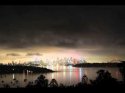
here is a pic of some cloud glow and clouds blocking, also trying the link since we can't upload pics
which seems to be broken....Hmmm have to work on this.