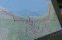
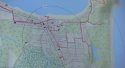
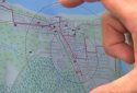
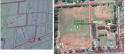
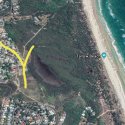
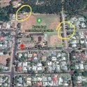
Well the map on the Belgium police laptop seems to show a red line of Theo’s known movements during his stay at Byron Bay, presumably up to his last ping. Better screenshots attached. According to the Belgium Police map, he never walked along Tallows Beach or up to Cosy Corner. The map shows him travelling (walking or by car) along Tallows Beach Road, but stopping at it’s end, and returning. He could have done this either earlier in the day, or after CM.
I’m more inclined to believe in the route shown on a police laptop than one produced by the Daily Telegraph. There’s no timeline that I can see on the map, but the only other one way route he took after leaving CM is along Lighthouse Road toward The Pass, Wategos and the lighthouse. So not walking along the main beach or around rocks, but on roads the whole time. IMO that means he got in a car after leaving CM and visited a few spots by car. Unfortunately the police laptop screen does not show the final end point of his route, but it is somewhere between Wategos and the lighthouse. Maybe he did just fall from up there (cliffs next to the lighthouse) by accident and the people/person who drove him up there are too scared to come forward for whatever reason.
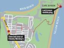
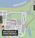
Am frustrated by confusion caused by the two different maps. Maybe the pulled post was removed because it was in fact inaccurate. Which one is correct?!