Eyerish Eyes
Active Member
- Joined
- Jan 28, 2022
- Messages
- 40
- Reaction score
- 231
On Google Earth this white cross is not far from crash scene. It’s north toward Wagner Wash. Has anyone seen this out there? What is it? 
Last edited:

Follow along with the video below to see how to install our site as a web app on your home screen.
Note: This feature may not be available in some browsers.
It could be a small airplane. It looks like a driveway or lane leading to it. Could that be a landing strip instead of lane?On Google Earth this white cross is not far from crash scene. It’s north toward Wagner Wash. Has anyone seen this out there? What is it? View attachment 370765
Looks like it could be a helicopter landing pad.It could be a small airplane. It looks like a driveway or lane leading to it. Could that be a landing strip instead of lane?
Recall seeing this in a video recently - drone landing pad IMO.On Google Earth this white cross is not far from crash scene. It’s north toward Wagner Wash. Has anyone seen this out there? What is it? View attachment 370765
Those are markers placed by the county for GIS mapping.On Google Earth this white cross is not far from crash scene. It’s north toward Wagner Wash. Has anyone seen this out there? What is it? View attachment 370765
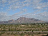
My best guess is Camelback MountainLong time, no post. Thinking back to @JJRay’s crash scene video - can anyone ID the peak (arrowed)/range at the top left? Belmonts?
View attachment 372528
My best guess is Camelback Mountain
My eyes are old though, so just a guess
Camelback Mountain - Wikipedia
Camelback Mountain - Wikipedia
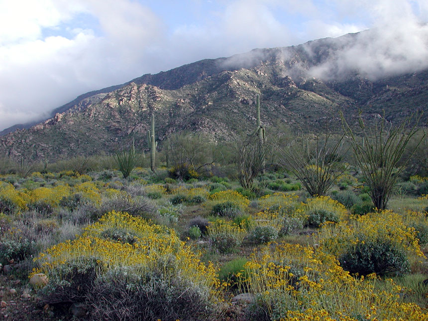
Attached is a still from JJRay’s crash scene video - I used the rollover simulation photo above as it gives a clearer view of the range/peak. Both are taken in line with the direction of DR’s travel immediately prior to going in to the ravine - approximately north-west. The JJRay video image is taken from roughly the spot where he believes the Jeep stopped briefly before taking off at speed and going into the ravine.It does look a little like Camelback, but Camelback is right in Phoenix and Daniel was out west near Buckeye. I'm guessing it's the White Tank Mountains (my first guess) or Belmont Mountains (I think less likely as they are more unique looking).
His dad's website has an ARCGIS map of the location his car was found and the areas they are searching:
ArcGIS Web Application
matrixneworld.maps.arcgis.com
I wish I could tell which way his car was pointing in that picture. Does anyone know? If we knew that, we could easily identify the range. I'll do more digging.

Well if we're looking NW, it's definitely not the White Tanks, my bad.Attached is a still from JJRay’s crash scene video - I used the rollover simulation photo above as it gives a clearer view of the range/peak. Both are taken in line with the direction of DR’s travel immediately prior to going in to the ravine - approximately north-west. The JJRay video image is taken from roughly the spot where he believes the Jeep stopped briefly before taking off at speed and going into the ravine.View attachment 374201
I wonder why it stopped briefly. IMO it shouldn't have stopped at all. IDK that seems odd. It should have kept going if it was headed to the ravine why stop? Does anyone know?Attached is a still from JJRay’s crash scene video - I used the rollover simulation photo above as it gives a clearer view of the range/peak. Both are taken in line with the direction of DR’s travel immediately prior to going in to the ravine - approximately north-west. The JJRay video image is taken from roughly the spot where he believes the Jeep stopped briefly before taking off at speed and going into the ravine.View attachment 374201
Could be - I’m finding it hard to figure from Google Earth alone. If that was his target, my current best estimate as to his direction of travel after the crash would be approximately west north-west along the white line in the image below - though obviously Harquahala is another 25+ miles further west and he would have to divert in order to cross a canal (black line) before coming to any mountains.Well if we're looking NW, it's definitely not the White Tanks, my bad.
It could be the Harquahala Mountains:
Harquahala Mountains - Wikipedia
en.wikipedia.org

I wonder how far back he stopped (briefly) from the ravine actually because if he stopped far back enough he would be able to see the ravine and know there was a dropoff he would hit. Ok, if he can't see from in front for example he's too close he would at least be able to see from his driver's side window and from passenger's side window. Honestly if he was orienting himself with where he was and where he was going that would mean he was coherent and making a logical thought IMO.Attached is a still from JJRay’s crash scene video - I used the rollover simulation photo above as it gives a clearer view of the range/peak. Both are taken in line with the direction of DR’s travel immediately prior to going in to the ravine - approximately north-west. The JJRay video image is taken from roughly the spot where he believes the Jeep stopped briefly before taking off at speed and going into the ravine.View attachment 374201
Isn't that like 3+ hours away?Human remains found, male, wrapped in tarp NW AZ.
Human remains found in northwestern Arizona; no identity yet